


blufjr
blufjr
WA Dam Ride
by Ken Hattan

I do this event every year called the DamTour and usually do two 4-5 day rides picking up dams. This year I scheduled a Washington Dam ride in May and completed it May 21. It was a 4 day ride, approximately 365 miles each day and I picked up 15 dams of which one was in Idaho and one in Montana.
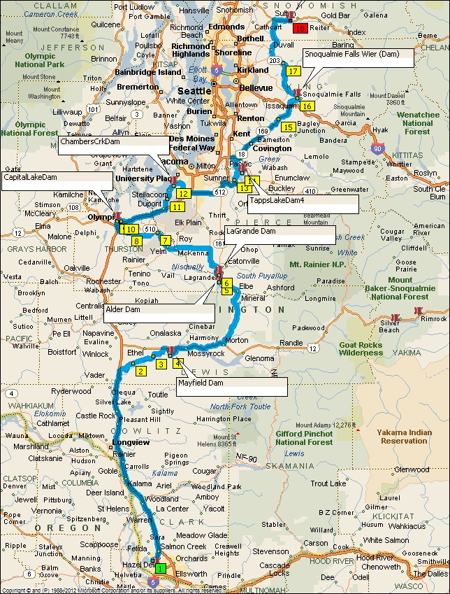
Day one took me North from Vancouver, WA to Monroe. I left I-5 at Toledo and took a short cut to US 12 by way of Spencer Rd. This is always a good road as there is little traffic and a few good corners, and barns. My first stop was at Mayfield Dam. It has a view point but nothing spectacular. At Morton I turned North on WA7 and headed for Alder Dam. Although you can ride down and turn around on the dam, it is gated so you can't cross over it. This is a good viewpoint to see the dam and the outflows. On up the highway I stopped at an overlook for LaGrande Dam but you really couldn't see much, only a little white water and a hint of concrete. There was a plaque that informed you that there was a dam there. Highway 7 is a treat and has some good twisty sections and should be taken if you want to avoid I-5.
I crossed over I-5 at Olympia, or rather went under it just south of Olympia and headed for Capitol Lake. There I found Capitol Lake Dam, looking like a restroom facility on the side of the road and part of Marathon or Heritage Parks, but if you get off your bike, you can see the water level is different on each side, and there isn't any restroom facilities. Nice view of the Capitol Building across the lake. Next I headed for Chambers Creek Dam. You have all heard of Chambers Bay Golf Course (US Open a few years back), well this is in the neighborhood. After leaving I headed East for Tapps Lake, where there are multiple dams that contain the lake. Also referred to as dikes. I only stopped to take a picture of Tapps Lake Dam No. 4, although I passed others. My next stop was my nephews house in Monroe by way of Snoqualmie Falls, which I stopped to take a picture and by chance saw it also has a Dam (a Weir, don't get technical). In the picture you can see Snoqualmie Falls Dam just above the falls. Historically it has had a powerhouse since 1898. en.wikipedia.org/wiki/Snoqualmie_Falls_Hydroelectric_Plant . This was a surprise find for me as it wasn't on my original route and was not a planned destination. I left two hours late this morning and had to make up some time, so I took the back roads on the East side of I-5. Original plan was to go by Ballards Locks and Dam (Chittenden Locks and Dam), but that took me through Seattle at rush hour and I might have had trouble getting to Monroe at a reasonable hour.
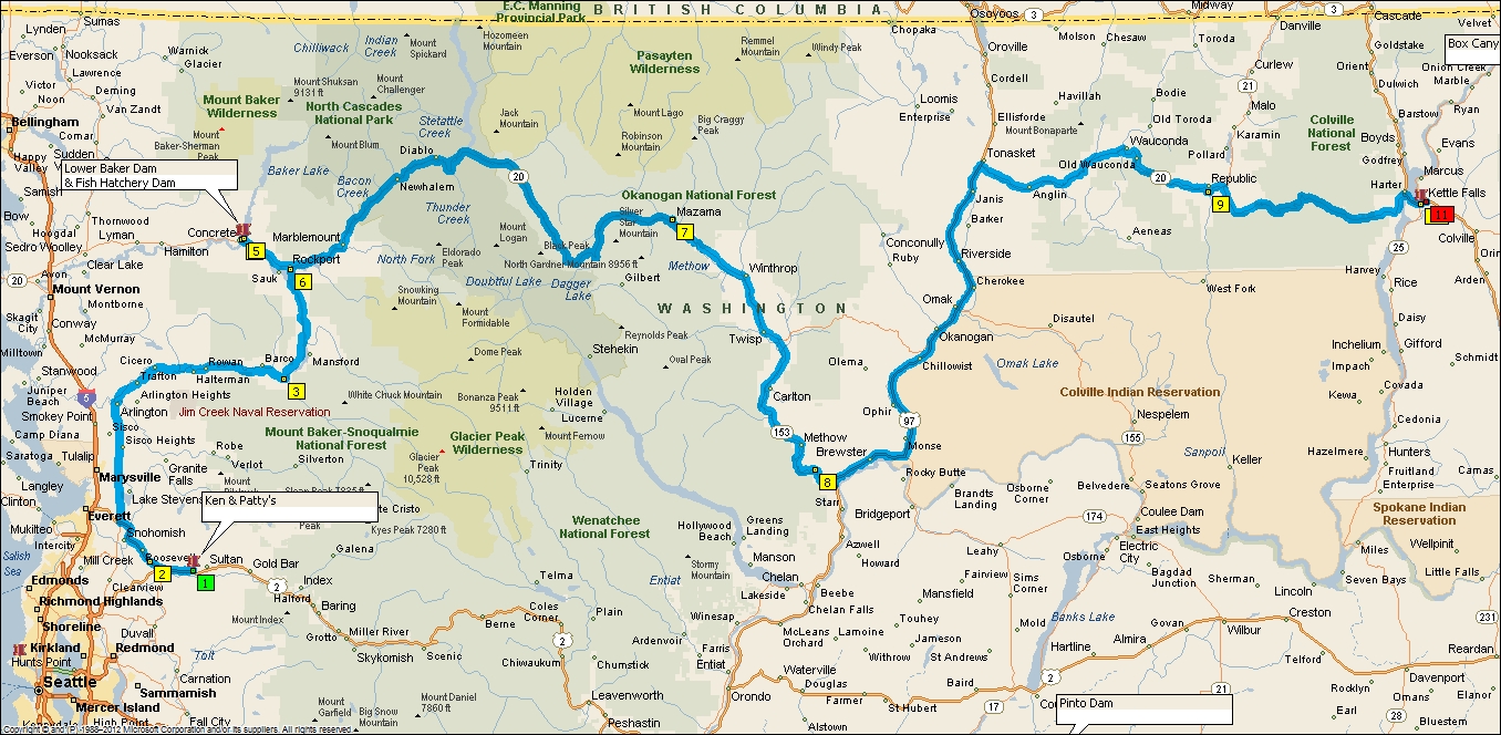
Day 2 took me further North to the Northern Cascade Highway, WA20, and over Washington Pass headed for Kettle Falls for the night. My first stop was at the Fish Hatchery Dam below Lower Baker Dam. Baker was the guy that built Snoqualmie Falls Weir and hydroelectric plant. Bypassing Diablo and Ross Dams I went straight away to experiencing the road. WA20 is one of Washington's great roads to experience, and in many ways. This day was dedicated to the Ride. After the passes the road descends down the east face of the Cascades into high plateaus and interesting towns such as Winthrop and Twisp (more for the name). Loop Loop Pass was blocked by a landslide and I had to detour through Pateros adding 35 miles to the ride. Did I say, I got a late start this day too. I'm not in a big hurry to get on the road early as I used to be, after having two deer strikes last year. So leaving before 8 am is okay especially when you are going to be riding in the mountains and through forests, which I would be doing all day. I followed WA20 across Washington through Republic and on to Kettle Falls. Excellent ride through mountains, valleys, and forests.
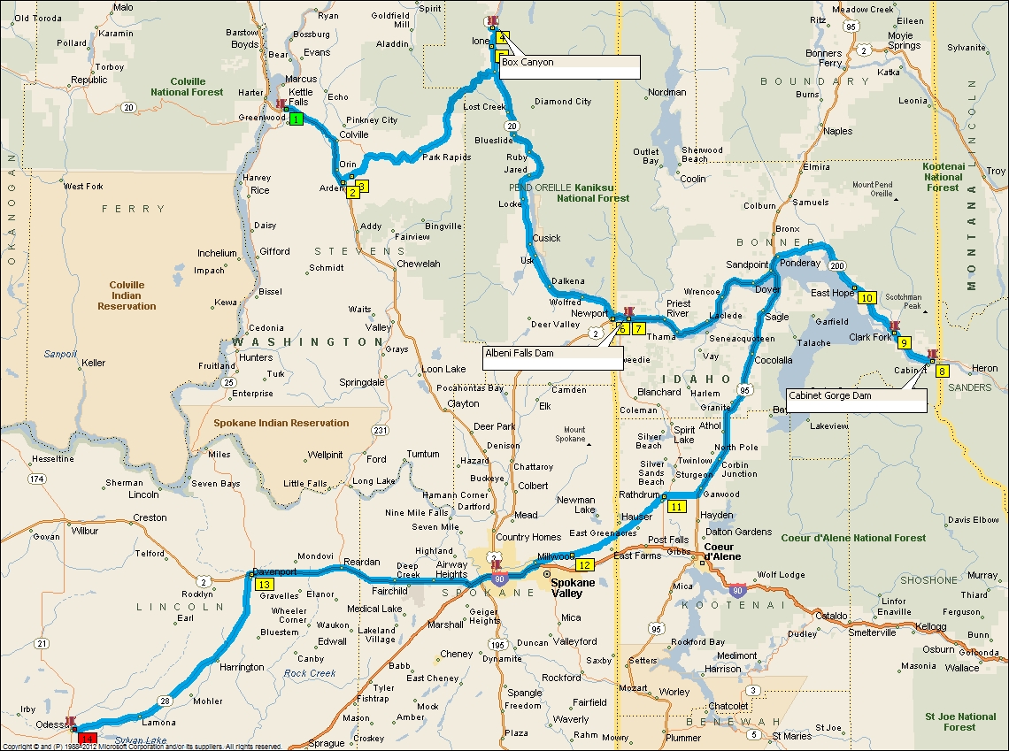
Day 3 had me wondering all the way to Montana. Picked up Box Canyon Dam in the early morning, in the rain, after heading down the wrong road out of Colville. I ended up cutting back to WA20 on county roads that were a lot of fun, maybe more than the main highway. I ate breakfast in Colville to help avoid the deer, didn't see any so it must of worked. After crossing the border into Idaho, I stopped at Albeni Falls Dam. Too bad they built this dam as the original falls were a triple falls and would have looked fantastic. Albeni (first name) built a resort there and people would come up from Spokane to see the place. Now remember, Spokane also had a triple fall. Had until they built a dam and powerhouse. The West was a much more beautiful place before the western Europeans came, and even after when electrical power from hydro became the rage, even into the 1950's. IE: The Dalles Dam wiping out the World's fourth largest waterfall, US's largest, by volume. After Albeni, I headed to Sandpoint, ID and on to Cabinet Gorge Dam in Montana. What a thunderous out pouring of water in the spring. I removed some of my layers, but kept the rain gear on just in case there was a thunder storm as I headed back west towards Spokane. A little slow at getting my start in the morning, so I skipped the dams at Spokane and headed for my night stop in Odessa, WA. Great little cafe, bar in Odessa called Chief's Bar and Grill. Had a great time talking to locals and travelers.
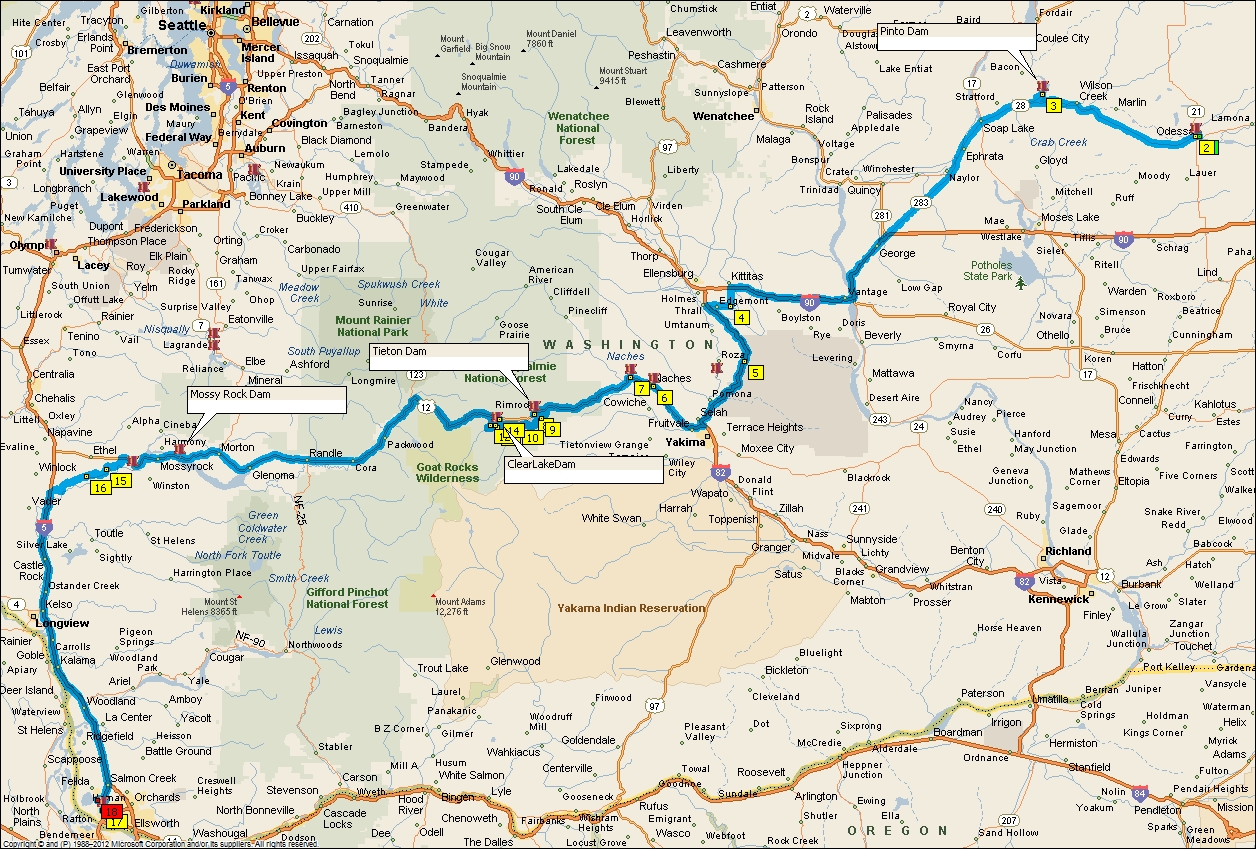
Day 4 takes me home, by way of a number of dams. First up was Pinto Dam, then Tieton Dam, Clear Lake Dam and Mossy Rock Dam. I had to miss the Canyon ride due to bicycle event on that road, and therefore missed Roza Dam. Stopped in Naches for a bite, no recommendations there, and skipped the irrigation dam further up US12 near the fork to WA410. On to Tieton Dam, which is a hard dam to photograph from the highway. You can pull off on the east bound lane before the tunnel, but nothing down stream below the dam. I haven't investigated approaching on the gravel road at the foot of the dam, but did very much enjoy the ride around the reservoir on the forest roads. Doing these roads puts you right at Clear Lake Dam, which has one of the most beautiful spillways you will ever find. Small but a beauty. Over White Pass and on to Mossy Rock Dam. Taking Spencer Rd to I 5 is a must as highway 12 gets boring after Mossy Rock. Down I-5 to Vancouver and arriving at home around 4pm. Outstanding ride for four days, 1350 miles and 15 dams.
Pics Here:
by Ken Hattan
I do this event every year called the DamTour and usually do two 4-5 day rides picking up dams. This year I scheduled a Washington Dam ride in May and completed it May 21. It was a 4 day ride, approximately 365 miles each day and I picked up 15 dams of which one was in Idaho and one in Montana.

Day one took me North from Vancouver, WA to Monroe. I left I-5 at Toledo and took a short cut to US 12 by way of Spencer Rd. This is always a good road as there is little traffic and a few good corners, and barns. My first stop was at Mayfield Dam. It has a view point but nothing spectacular. At Morton I turned North on WA7 and headed for Alder Dam. Although you can ride down and turn around on the dam, it is gated so you can't cross over it. This is a good viewpoint to see the dam and the outflows. On up the highway I stopped at an overlook for LaGrande Dam but you really couldn't see much, only a little white water and a hint of concrete. There was a plaque that informed you that there was a dam there. Highway 7 is a treat and has some good twisty sections and should be taken if you want to avoid I-5.
I crossed over I-5 at Olympia, or rather went under it just south of Olympia and headed for Capitol Lake. There I found Capitol Lake Dam, looking like a restroom facility on the side of the road and part of Marathon or Heritage Parks, but if you get off your bike, you can see the water level is different on each side, and there isn't any restroom facilities. Nice view of the Capitol Building across the lake. Next I headed for Chambers Creek Dam. You have all heard of Chambers Bay Golf Course (US Open a few years back), well this is in the neighborhood. After leaving I headed East for Tapps Lake, where there are multiple dams that contain the lake. Also referred to as dikes. I only stopped to take a picture of Tapps Lake Dam No. 4, although I passed others. My next stop was my nephews house in Monroe by way of Snoqualmie Falls, which I stopped to take a picture and by chance saw it also has a Dam (a Weir, don't get technical). In the picture you can see Snoqualmie Falls Dam just above the falls. Historically it has had a powerhouse since 1898. en.wikipedia.org/wiki/Snoqualmie_Falls_Hydroelectric_Plant . This was a surprise find for me as it wasn't on my original route and was not a planned destination. I left two hours late this morning and had to make up some time, so I took the back roads on the East side of I-5. Original plan was to go by Ballards Locks and Dam (Chittenden Locks and Dam), but that took me through Seattle at rush hour and I might have had trouble getting to Monroe at a reasonable hour.
Day 2 took me further North to the Northern Cascade Highway, WA20, and over Washington Pass headed for Kettle Falls for the night. My first stop was at the Fish Hatchery Dam below Lower Baker Dam. Baker was the guy that built Snoqualmie Falls Weir and hydroelectric plant. Bypassing Diablo and Ross Dams I went straight away to experiencing the road. WA20 is one of Washington's great roads to experience, and in many ways. This day was dedicated to the Ride. After the passes the road descends down the east face of the Cascades into high plateaus and interesting towns such as Winthrop and Twisp (more for the name). Loop Loop Pass was blocked by a landslide and I had to detour through Pateros adding 35 miles to the ride. Did I say, I got a late start this day too. I'm not in a big hurry to get on the road early as I used to be, after having two deer strikes last year. So leaving before 8 am is okay especially when you are going to be riding in the mountains and through forests, which I would be doing all day. I followed WA20 across Washington through Republic and on to Kettle Falls. Excellent ride through mountains, valleys, and forests.
Day 3 had me wondering all the way to Montana. Picked up Box Canyon Dam in the early morning, in the rain, after heading down the wrong road out of Colville. I ended up cutting back to WA20 on county roads that were a lot of fun, maybe more than the main highway. I ate breakfast in Colville to help avoid the deer, didn't see any so it must of worked. After crossing the border into Idaho, I stopped at Albeni Falls Dam. Too bad they built this dam as the original falls were a triple falls and would have looked fantastic. Albeni (first name) built a resort there and people would come up from Spokane to see the place. Now remember, Spokane also had a triple fall. Had until they built a dam and powerhouse. The West was a much more beautiful place before the western Europeans came, and even after when electrical power from hydro became the rage, even into the 1950's. IE: The Dalles Dam wiping out the World's fourth largest waterfall, US's largest, by volume. After Albeni, I headed to Sandpoint, ID and on to Cabinet Gorge Dam in Montana. What a thunderous out pouring of water in the spring. I removed some of my layers, but kept the rain gear on just in case there was a thunder storm as I headed back west towards Spokane. A little slow at getting my start in the morning, so I skipped the dams at Spokane and headed for my night stop in Odessa, WA. Great little cafe, bar in Odessa called Chief's Bar and Grill. Had a great time talking to locals and travelers.
Day 4 takes me home, by way of a number of dams. First up was Pinto Dam, then Tieton Dam, Clear Lake Dam and Mossy Rock Dam. I had to miss the Canyon ride due to bicycle event on that road, and therefore missed Roza Dam. Stopped in Naches for a bite, no recommendations there, and skipped the irrigation dam further up US12 near the fork to WA410. On to Tieton Dam, which is a hard dam to photograph from the highway. You can pull off on the east bound lane before the tunnel, but nothing down stream below the dam. I haven't investigated approaching on the gravel road at the foot of the dam, but did very much enjoy the ride around the reservoir on the forest roads. Doing these roads puts you right at Clear Lake Dam, which has one of the most beautiful spillways you will ever find. Small but a beauty. Over White Pass and on to Mossy Rock Dam. Taking Spencer Rd to I 5 is a must as highway 12 gets boring after Mossy Rock. Down I-5 to Vancouver and arriving at home around 4pm. Outstanding ride for four days, 1350 miles and 15 dams.
Pics Here:
Last edited by a moderator:
