Scotland, 2018. Subtitle: What could possibly go wrong?

Yamaha FJR Motorcycle Forum

Help Support Yamaha FJR Motorcycle Forum:

This site may earn a commission from merchant affiliate links, including eBay, Amazon, and others.

mcatrophy

Privileged to ride a 2018 FJR1300AS
Joined
Aug 25, 2006
Messages
4,332
Reaction score
1,824
Location
Derby, UK
This is the latest of many rides I've done to Scotland. The plan was for 8 nights away from home, all organised by R from the Channel island of Guernsey. All of our group I've been with before, R on his Multistrada, J the only lady on an F800, Mo, an old Guernsey friend of R's who now lives in England, Mi another Channel Islander but from Jersey riding a somewhat venerable Trident, my son on his Monster 821, and me on my FJR.

All hotels were booked, the weather didn't look too bad for the week, so everything seemed good to go.

(Click on any image for larger view)


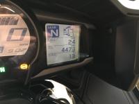
Bike odometer at start of trip: 4473

Day 1 - The Meet, Innerleithen.

We planned to meet up at a hotel in the Scottish Borders, one we've used many times before.

Son and I had decided to ride up separately. I had quite a good run up, only a little filtering required on the M6. Turned up at the hotel, R was already there. He and Mi have to catch ferries from Guernsey and Jersey the day before. They stayed (separately) overnight part way up, and completed their journeys today.

I arrived in good time, only R was there (he's renowned for making "good progress"). As I'm sorting myself out, I find a message my phone from Son. "Waiting for the RAC to get my bike going."

Turns out he had made a mistake fuelling his bike at a motorway service station, and had put diesel in his bike instead of petrol. I taught him all I know, and still he knows nothing. Without realising what he'd done, he'd ridden several miles further before his bike gave up and stopped running. He managed to push the bike off the motorway up a slip road, and phoned the RAC rescue service.

To cut a long (four hours?) story short, they got him running again, and he arrived late at the hotel, the rest of us all there in good time.

Oh, yes, I had the gentlest of drops, stopping in traffic to put my foot down into the only hole in the road for miles. Minor but annoying scratches. At least the mirror frame didn't break.

Click for route (misses the first few miles)


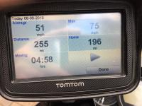
Tomtom's summary for the day (can't believe the maximum speed)

255 miles

Day 2 - Innerleithen to Dinnet


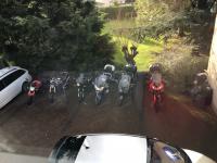
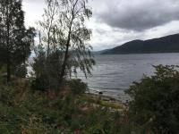
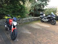
Morning view of parked bikes

Had breakfast, went into the car park to find this:
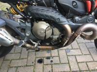


Unhappy Monster

Oil is running down from the top of the crankcase, there's also evidence of oil being burnt. And, of course, oil on the back tyre - it's a good job son was riding in the dark on unlit country roads, so wasn't riding hard.

My personal view is that he has stuck piston rings. The crankcase is being pressurised and the oil is coming out of the breather pipe that goes to the airbox. As yet, nothing confirmed.

I wait with son while he contacts the RAC again, no reason to delay the others on the planned scenic route.


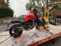
Waiting for the RAC. Almost ready to transport

So I take a less scenic route to the next hotel, meanwhile son and Monster head for the nearest Ducati dealer in Glasgow. He hopes to get them to take a look, but this is Sunday.

When he gets there, the workshop is closed as expected. Could he stay overnight and they look at it in the morning? Er, no, they are shut on Mondays. Anywhere he can hire a bike? Only place is a Harley dealer nearby, but Son won't be seen dead on a Harley.

After some further conversation with the RAC, he finds he can have a hire car for three days (this gets complicated because he has two RAC covers, one through his bike insurance, and his own paid-for cover for his car). So, he goes to the car-hire place at the airport. "Yes sir, certainly sir. Can I see your driving licence?" Er, no, it's at home. "Sorry sir, can't hire you a car without it."

So, he will catch a train home tonight, hire a car in Derby in the morning, and drive the 500 mile, 9 hours 20 minute trip to meet us at our next hotel on the Isle of Skye tomorrow.

My route


Tomtom's summary for the day (still can't believe the maximum speed)

192 miles

More to follow ...

 
Last edited by a moderator:
Deer_eating_popcorn2_zps031b187f.gif


...sounds like an adventure is on the horizon! Looking forward to the next installment.
bike.gif


~G

 
Last edited by a moderator:
Annie and I spent a week roaming around Scotland in a Fiat X19 back in the 70s. We often reminisce about that trip and talk of doing it again on bikes. This thread will have to hold us for the time being. Looking forward to reading more.

 
Annie and I spent a week roaming around Scotland in a Fiat X19 back in the 70s. We often reminisce about that trip and talk of doing it again on bikes. This thread will have to hold us for the time being. Looking forward to reading more.
You two are really the adventure riders around here.. that's a compliment..

 
Day 3 - Dinnet to Sconser (Isle of Skye)

It rained most of today.

I rode sweep.

We have unwritten rules about our group rides which we stick to quite firmly. We don't change our order unless agreed between us; at turn-offs we wait until we know the one behind has seen us; and, most importantly, we are each responsible for our own safety.

In the past Mi has usually been sweep, he likes to "play" a little, hanging back and catching up. He's one of those riders who you are not really aware of, is very smooth, and can cover ground deceptively quickly. Since I hadn't ridden with the group yesterday, I tagged on to the back. No problem for me, I, too, sometimes like to play a little.

Because of the rain, we didn't stop much, however it cleared a little as we passed Loch Ness. With the possibility that the monster might rise to the surface, we stopped to see if there were any signs.

(Click on any image for larger view)

0_IMG_4226.JPG


On the B8562 overlooking Loch Ness, no sign of the monster

Yup, no sign of any monsters, Nessie or Son's Ducati. I hadn't really expected to see either.

And, a bit later on:


Overlooking Loch Garry, the bikes overlooking Glen Garry

While this might seem a bit of a dull day, to me it wasn't. We rode over some of Scotland's better motorcycling roads, many were single track (with passing places), tight bends, challenges like gravel swept to the centre by the cars, but usually with good sighting of the road ahead. Not much grows in the Highlands except in sheltered spots.

Views were, at least to me, incredible, but then I do like windswept (did I mention it was very windy today?) rain-sodden bleak countryside. (Ok, I'm a bit strange, but harmless. Mostly.)

We used the bridge to get on to the Island of Skye. I was a little surprised, R usually takes every opportunity to use a ferry. Part of his living on an island, I suppose. Talking of ferries, R had planned to leave Skye by ferry, but hadn't booked the tickets. His planning had got distracted because of the recent death of his mother (91, so not too much of a surprise, she'd been unwell for some time). So, while the rest of us made our way to the hotel, R beetles off to the ferry terminal to book the tickets. He later recounted how that went.

"I would like to book the ferry for five motorcycles, please."

"No."

"Why not? Is the ferry full?"

"No, we're not taking motorcycles today, it's too rough."

"Ah, not for today, in two days' time (we are having two nights here)."

"Ok then, you can book, but there's no guarantee on the weather (did I mention it was a bit inclement?)."

So, we settled in for the night, they provide very good food, and a welcoming bar. What more could you ask for?

Today's route


Tomtom's summary. I can almost believe the maximum speed. (Except no 70 limit roads on this leg, so I still can't.)

193 miles

 
Last edited by a moderator:
Day 4 - The island of Raasay and a Skye loop

We wake up to a change in the weather.

(Click on any image for larger view)


Morning view from the hotel. Raasay is to the right.

After breakfast (typical choice of eggs, bacon, sausage, black pudding, white pudding, haggis, baked beans, potato scone, toast ... plus some healthy options), we rode the few hundred yards to the ferry terminal to take us to the island of Raasay. This island has very few roads, a small population, no tourist places to visit. So, I can hear you ask, "Why on earth would you want to go there on a motorcycle?".

We do that sort of thing. It's there. Some of our group have been before, but two haven't. So, why not?


The ferry approaching the ramp

The terminal on Raasay has been moved. Well, a new one built, the old one abandoned. We rode round to the old one.


The old ferry terminal

Apparently, the new one was built because the original was too exposed, so likely to be closed because of the weather. So why was the original built in a bad place? Because it was built to service nearby iron ore mine workings.


Old mine-work buildings

One of the unusual features on Raasay is Callum's Road.


The start of Callum's Road, and parked a little way up

We stopped to read a plaque there:


The plaque reads:

[Lots of Gallic stuff which means nothing to me, then the English translation]

CALLUM'S ROAD

THIS FORMER FOOTPATH TO ARNISH - A DISTANCE OF 1 3/4 MILES -

WAS WIDENED TO A SINGLE TRACK ROAD WITH

PASSING PLACES AND PREPARED FOR SURFACING BY

MALCOM MACLEOD, B.E.M.

(1911-1988)

SOUTH ARNISH.

HE ACCOMPLISHED THIS WORK SINGLE-HANDEDLY

OVER A PERIOD OF TEN YEARS.

I gather he had tried to get the local council to make up this road, but they refused, so he did this out of shear stubbornness. Supposedly, the remains of his shovel and wheelbarrow are at the base of the sign in the above picture.

We didn't ride all the way up this road. It's a very poor surface, and Mo suffers from arthritis in his wrists, which causes him considerable pain on this type of road.

As we turn back, the weather closes in.


Raining again.

So a cup of tea is in order. We find a local shop (THE local shop?), "Where can we get a cup of tea?" "Well, the power on the island is out, but you might try the Community Hall down the road, they should be on a standby generator." (Which they are, shared with the school and its six pupils.)

We get to the hall, to find tables set out. We sit at one, and a lady comes to take our order, "Tea for 5, please".

So, she brings enough tea to drown a small army, then several plates piled high with home-made cake, biscuits, sundry other good-looking stuff to eat. None of us are hungry after our breakfast, but we have to eat something so as not to hurt any feelings. Delicious. So, stuffed to the gunnels, "What do we owe you?" "Oh, just leave a donation. Would you like any more cake?" After a chat - I think they like having strangers from the outside world to talk to - we leave a suitable donation.

Before catching the ferry, we stop at a junction with some Forestry Commission roads, we've plenty of time before the next ferry. And there are some nice trees around that might benefit from a little extra watering.


Not much to see, but if you are a walker, there are some good walks around starting here.

Then the ferry back to Skye, and we ride to the west coast of Skye where we stop to look at the scenery.


Overlooking Loch Harport, a sea loch on the west coast of Skye


Bikes wait patiently

On to Neist Point, the most westerly point of Skye. Well known for being very windy, as we found to our cost back in 2009.


Back in 2009: too much wind can do this

There's a lighthouse that I didn't go to see, but I did look at the views.


Steps down to the lighthouse and view of the sea

Towards the left of that last picture there's a waterfall famed for "falling" up the cliff. A cropped part of the image:


Waterfall blowing up the cliff

The water falls half-way down, hits an outcrop and splashes out. The wind catches it and blows the water right up over the cliff.


Hanging on to the railing. It IS windy.

Then back to the hotel for our second night there.

Just in time for dinner, Son arrives in his hire car, having driven up from Derby. Took longer than it should have because his phone navigation insisted he should go to the ferry terminal to get from the mainland to Skye, even though he'd got it set to avoid ferries. (The phone was recognised by the car, its screen was offered on the car's big screen, but it would only use Apple Maps, not Google Maps.) This was a diversion that added 3/4 of an hour.

Today's route.


Tomtom's summary (still don't believe the maximum speed)

111 miles

 
Last edited by a moderator:
Thanks for taking your time to do this RR. The RR is taking me to places that I'll never get to.

Loved the pictures of the Tomtom with rain drops on the screen.

You, like us folks living in the Pacific Northwet, must have some good rain gear.
bike.gif


Day 5 - Skye to Gairloch

(Click on any image for larger view)


Morning view from the hotel

If you ask Google Maps for a route from our Skye hotel to our Gairloch hotel, it will say 88.6 miles, 2 hours 9 minutes. Clearly too short, and no ferries involved. So, we go a slightly longer route. With a ferry. (Did I mention R likes ferries?)

Last night, R got a message from the ferry company saying they didn't know whether we could travel this morning. Chatting with the hotel owner at breakfast, he offers to ring up to find out the latest. He gets an automated answering thingy that says they might or might not be sailing, and even if they do, they may not be taking bikes. You could think that, judging by the pictures above, the weather was perfect. However, our hotel is on a very sheltered bit of coast, the ferry terminal is much more exposed. There's a clue to the possible weather in the waves visible in the second picture above, very rare here. There is certainly some significant weather about.

So, nothing for it but to meander down to the Armadale ferry terminal and await the Captain's Decision.


Bikes waiting in the queue

There's time for a cup of tea, and to chat to some of the locals ...


A somewhat windswept robin hoping for breakfast


Ferry appears out of the gloom

The ferry docks, only then are we told that we will be taking the bikes on board. We board first ...


Bikes are tied down

Meanwhile, Son has driven down, got himself a stand-by ticket, and got on board. He's decided to try to at least meet up at known stopping points, without necessarily trying to follow us.

After an uneventful sailing (albeit with some swell), we disembark at Mallaig (almost last off) and go a few miles to a point where we can look down Loch Morar.

A few pictures here. As usual, they cannot do justice to the views, but they at least remind me.


Views across Loch Morar. Lighting makes photography very difficult.


Views from the jetty, and looking back to the bikes (and Son's hire car)

We ride past Loch Nan Uamh and Loch Ailort (both sea lochs), past Loch Eilt to Glenfinnan, where there's a railway station and a bit off a railway museum. This has become a favourite stopping off point for us.


Snow plough on the left, then a dining car restaurant. Behind is a signal box.


We're inside, having a cup of tea. And homemade cake.

Leaving here, next stop (apart from fuel) is the view point on Bealach na Ba (Pass of the Cattle).

We've gone by or through (deep breath) Loch Shiel, Loch Eil, past Neptune's Staircase (a series of locks raising the water level some 92 feet in quarter of a mile, built between 1803 and 1822). We skirt Fort William (always very busy and touristy), Spean Bridge, past the Commando Memorial (much training done here for WW2), Loch Lochy (very nice views over water). Loch Garry, Loch Cluanie, Loch Dutch, Loch Carron. (There are a lot of lochs in Scotland).

Finally, it's the Pass of the Cattle. As the name suggests, it was used to drive cattle to and from the very remote village of Applecross. Rises up steeply, with several very tight, narrow and sloping hairpins. Visibility can be very variable, ranging from bright sunshine to misty down to sea level (very dangerous to go up). Often it's clear at the bottom, and you are in thick cloud at the top. Today we were quite lucky, raining but reasonable visibility, so a few pics from the view point.


A pointer to what you can see. Difficult lighting, so an original, and enhanced a bit

And a few more, part of a sort of panorama (click on any thumbnail, click on the "more" link, you can see more of them)


Yes, there's some blue sky


Bikes randomly parked amongst an awful lot of water

Having had our fill of the views, the wind and occasional squally showers, we set off for the next leg.

Down through steep hairpins towards Applecross and the coast, northwards following the coast. We stop to look over where the BBC made a survival program, giving the impression that this was miles from anywhere.


Dead centre is the survival cottage, next door to a Ministry of Defence building.


Road cloudy in front, sunny behind (7 seconds between photographs)

Sunshine and showers meant we were frequently seeing some strong rainbows, often double, and possibly treble (though it's difficult to stare at the sky looking for that elusive third when piloting a motorcycle along single track winding roads).

And finally to the hotel in Gairloch. One of the best hotels for us, except the owner insists on piling the plates too high with food. No room for a pudding if you are totally stuffed with the main course. Son also made it here, he'd also gone over the Pass of the Cattle. Said he'd much rather have been on a bike.

Today's route


Tomtom's summary (wot maximum speed?)

237 miles

 
Last edited by a moderator:
Day 6 - Gairloch to Overscraig

Today we do a somewhat crazy route (check the route link below). The weather looks a little precarious.

(Click on any image for larger view)


Looking out through the mirk, Skye on the left horizon

Those with separate wet weather over-gear don it at the start.

The route takes us over some of my favourite roads. We wind our way u[ the west coast of Scotland, stopping at the Knockan Crag nature reserve.

Information on some ancient rock formations


Unless we go walking quite a long way, there's not really much to see. Except for the view:


View from carpark over Lochan an Ais


Looks like rain in the air.

There are public toilets here, but they are closed. Never mind, bushes behind.

Onwards travelling basically north, past Loch Awe, then Loch Assynt with the ruins of Ardvreck Castle - we don't stop, miles to go, chocolate is calling. We cross the Kylesku Bridge, where Loch Gleann Dubh meets Loch a' Chairn Bhain. For some reason, I like this bridge, looks quite modern but doesn't clash with the scenery.


Kylesku Bridge

In this lay-by there is a cairn memorial to those who trained here as WW2 human torpedos.


Tablet on the memorial cairn

The writing says:

This cairn was erected to

commemorate the 50th anniversary of

the XIIth submarine flotilla

10th April 1993

The security of these top secret operations was

guarded by the local ;people of this district who

knew so much and talked so little.

The silent hills remember the young men of

His Majesty's X-craft submarines and human torpedoes

who were trained in these wild and beautiful waters

At the going down of the sun we will remember them
There follows a list of some 39 names, followed by a description of the 4-man submarines and 2-man chariots.

We leave Kylesku and head further north. Chocolate awaits.

We keep to the west coast as far as possible, Scourie More, Scourie, eastwards along the south coast of Loch a' Bhadaidh Daraich, northeast over Laxford Bridge, past several more lochs. We are on a road through some of the very remotest parts of Scotland, few villages, views of nothing but water, hills, mountains, all greens and browns with grass and heather, nothing else can grow in this exposed environment.

Finally we turn off to find the Balnakeil Craft Village, founded some years ago as some sort of commune by some hippies. It has a few shops selling handcrafted stuff, but our interest is the Coca Mountain, where they sell chocolates and ...


Hot chocolate

And, beside us there's this:


A chocolate-coloured animal.

This was the most northerly point for us.

Having made ourselves almost sick, we move on, to the west through Durness and stop above Caennabeinne Beach.


Caennabeinne Beach

To get some idea of scale, in the very centre of that last picture, there is a man walking up the beach. If I blow up the centre, you can just about make him out.


Speck in the centre is a man

We carry on, stopping on the Kyle of Tongue causeway


View from the Kyle of Tongue causeway


Bikes parked, backed up to an angel, together with an explanatory plaque

Half an hour later, we are at the River Naver


River Naver

Finally, we find our hotel in Overscaig.

This was my favourite day from the riding point of view, good roads (mostly), amazing views the whole time, weather not too bad.

Today's route


Tomtom's summary

217 miles

 
Last edited by a moderator:
Put off reading this until you got a few days into it. Sounds like a splendid trip for all except your son. (Doesn't he know the last good Italian engineer was Leonardo da Vinci?)

Ooh lah lah for the Kylesku Bridge! I love bridge porn!

 
Day 7 - Overscraig to TayChreggan

For some reason, I took no photos today. From what I remember, it rained a bit, so pictures might not have been "nice". Or, maybe my mind was elsewhere (more likely, it happens).

However, thanks to me at least remembering to tell Tomtom to record the route we did, I can describe it.

The first 16 miles or so we go down the northern side of Loch Shin. Views over the loch are generally intermittent, one place trees can grow is down to the shores of many of the lochs, it's a bit more sheltered. I don't think it's the water that they need, there's plenty off that all over Scotland.

Down through Invershin and past the Kyle of Sutherland. For those whose knowledge of Scottish Gaelic is as bad as mine, "Kyle" means a narrow sea channel. If you look at a map of where we are, this stretch of lochs and straights opens out into the North Sea through Dornoch Firth ("Firth" means a narrow inlet of the sea or an estuary).

We cross Bonar bridge to the south side of Dornoch Firth, then south to the worst road in Scotland, the A9. This is the main road up the east side of Scotland, filled with traffic, and, even if you can stretch your legs a bit, speed cameras, both single and average over long stretches. Unfortunately, it's not always easy to avoid it. But we're only on it for some 5 miles, and turn off almost straight south to Loch Ness. Still no monsters visible. Now we're travelling nearer south-west, along the north-west shore of Loch Ness, then Loch Oich, the south-east shore of Loch Lochy past the Cammando Memorial (we are doing a bit of the same route we did earlier, but in the opposite direction). Down through Gairlochy, along the River Lochy, through Inverlochy, the south side of Loch Oil (or it may be Loch Linnie, I can't tell from my maps), finally turning east to Ballachulish.

For the geologists, this part of the route, Loch Ness to Loch Linnie, follows the collision path of two tectonic plates, obvious if you look at a map of Scotland. Not a lot of geological activity there now, though.

Finally, we skirt round a mountainous region, past Loch Ba, Lochan na h-Achlaise (no, I'm not making these names up), Loch Tulla, through Bridge of Orchy (the place name, apparently named after the bridge; normally it's the other way round), Tyndrum (The Green Welly Stop provides fuel and tea, but very touristy and busy), then west along the River Awe, finally south again to Kilchrenan. The hotel there didn't have enough rooms there for all of us, so Son and I are booked into another hotel a mile or so further on.

Meanwhile, Son has been doing stuff concerning his bike. To cut a long story a bit shorter, he's been to Glasgow to check up on his bike (bad, an endoscope shows fuel poured into the plug hole runs straight past the piston into the sump, though actual damage not yet assessed). So he's not been with us at all today, and hasn't arrived at the hotel yet.

I check in at my hotel, R comes to me on his bike to take me back to join the others. For once I don't use ATGATT, just my helmet and jacket, in case I have to walk back to my hotel.

Son eventually polls up, just in time for dinner. I persuade him that he's not drinking tonight so he can run us back to our hotel later on.

Not even a Tomtom day summary picture. However ...

Today's route.

204 miles

 
Last edited by a moderator:
Day 8 - TayChreggan to Kingarth

(Click on any image for larger view)

Morning view from the hotel over Loch Awe

South-west along the west shore of Loch Awe to the village of Kilmartin, where we stop to look at a church. This was built in the 1800's, but there have been churches on this site for many centuries.


View of the church and across its graveyard


In the churchyard are stone slabs that were used to mark graves, some of these date back to the 1300's, the most recent are rom the 1700's.


Slabs stood up in what was a mausoleum


Many more laid out

Looking back at the church there's a weather vane on top that is somewhat unusual:

Weather vane with Viking ship, whale, porpoises, fish and a bird

We go further south down the west coast of Loch Fyne, onto the peninsular that leads to Kintyre (made well known due to a certain McCartney song; the "Mull" in the song refers to the headland, the southernmost tip of Kintyre). We stop at the ferry at Tarbert, so we don't "do" Kintyre.


Waiting for the Tarbert - Portavadie ferry, view over Tarbert harbour

We loop up the east coast of Loch Fyne to Strachur, then turn more southwest inland, down the east coast of Loch Eck down to Ardburg where we turn more west again (I did say it was a convoluted route).

The roads around here are all single track but with little traffic. Views show a few more trees, forests even, we're that much further south where tress can survive. Most of the forest are planted with pine, they are regularly harvested for the wood and replanted. Occasionally we might come across a logging truck. These tend to travel very quickly, and a couple of times some avoiding action has been necessary, but no harm done.

South again, Loch Riddon on our right, to the ferry at Colintraive. (Did I mention, R likes ferries?)


Yes, waiting for the Colintrave - Rhubodach ferry

A short trip over the waters onto the island of Bute. Why? Because none of us have been on it (and, I suspect, because R likes ferries).

Part-way down Bute, we pass through the surprisingly busy town of Rothesay, where we stop for fuel. It's raining, and I'm the last to fuel up. This is a tiny service station, only one place to fill, so the others wait while I do my fill. Behind me is a 4x4, phorsebox in tow, who's getting impatient (5 bikes being filled, one man serving petrol at an island pace, can't say I really blame him). As soon as I've paid, I move my bike forward to let Mr 4x4 fill, but I obviously didn't give him enough room; as I am trying to get my gloves on, he pips his horn. Well, ok, I can move forward a bit more, which I do. The group takes this as a sign that I am ready, and moves off. I am struggling to get my gloves on over wet hands, and I've managed to disturb the glove's lining so my fingers won't go in. Ok, we have our rule that the last one won't lose sight of me as they round the next corner, so should be no problem.

When I finally get the gloves on, I go round the corner. There is Mi waiting at the next turning. I catch up, we go round the turn, no sign of the group. Mo hasn't stopped. We know that the plan was to visit a Victorian mansion, but we don't know where it is. So, Mi and I explore for a bit, trying to see which way they went, no sign.

Finally we decide on the last resort, I tell Tomtom to find our evening hotel, then on the way we find the group waiting at a turning towards Mount Stuart, the mansion in question. However, it closes shortly, it's raining, so we go to the hotel, near the south end of Bute.

Later I have a quiet word with Mo. He said he couldn't stop because of the road layout. In reality, he could easily have stopped just round the corner, but I didn't press the point because he's the least experienced of us, and I didn't want to upset anybody.

Tomorrow it's home.

Today's route.


121 miles

 
Top