Fontanaman
Robin Trower
The wife and I decided to go for a motorcycle ride on Saturday. Where to go? Finally with our early winter head colds behind us we decide on the North Cascade Hwy going to Washington Pass then turn around, stop at the North Cascades National Park Visitor Center, the on to Cascadian Farms for a terrific ice cream cone.
It is a blue sky day and we start with a wife friendly departure time, about 10:00am. This works well as it has warmed up enough to keep her happy. Happy wife, happy life.
And speaking of the weather we having had a record dry spell going about 80 days with only .03" of rain. We north westerners (for Beemerdons Specific Northwetners) are giddy with delight, unless you live in a smoke filled valley down wind of a mountain fire such as Wenachee, Wa.
I had not been along the North Cascades Hwy since NAFO in June so it was time to get back before snow closes it for the winter. The time to ride in the low lands will come soon enough. Linda and I have been to Cascadian Farm for ice cream before so it is a easy bribe to coax her along, plus we get some fall colors along the way.
It was a great day of riding and on Sunday our plan was to go golfing. Sunday's plans changed about 8:30am on Sunday. The wife has arthritis and she is not up to golfing on Sunday leaving my day open. So I decide to head back to the North Cascades Hwy and do a loop ride. Why do it again?
Ah the North Cascades Highway. Only if all roads could be something like this. Going West to East the road starts off with a warm up out of Marblemount. Good tight twisties, the best ones, are right out of Newhalem, then let up a bit near Diablo and start up in earnest again to the Diablo Lake Overlook. There are a couple more tight turns after the Overlook, especially the decreasing radius turn at John Pierce Falls. This is the older section of road, pre 1968 and it shows in the tightness of turns and construction standards - yet the pavement is very good.
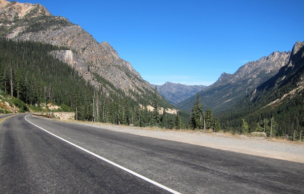
After the Ross Dam trail head parking lot there is a series of very nice sweeping turns for 10 miles or more. Just turn after turn after wonderful turn. As you approach Rainy and Washington Passes the turns give way, just a bit, to wonderful alpine mountain scenery.
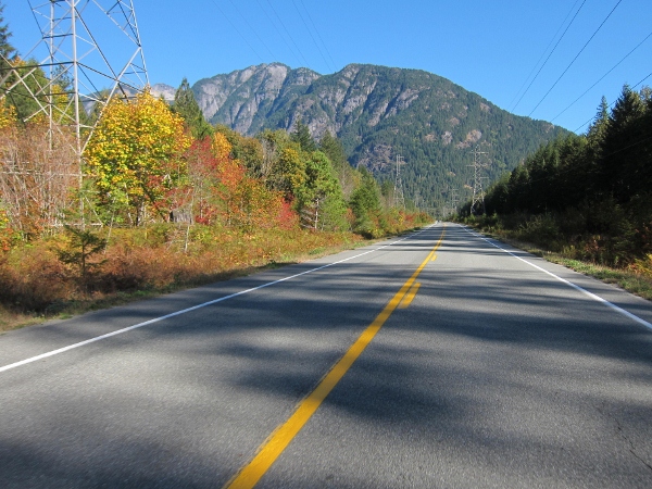
North Cascades Hwy coming into Newhalem
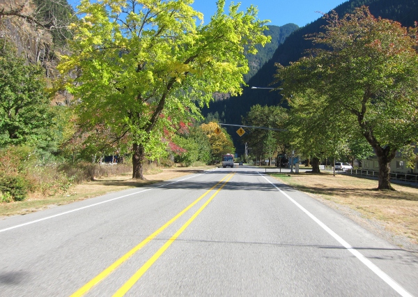
North Cascades Hwy in Newhalem. Do not speed here!
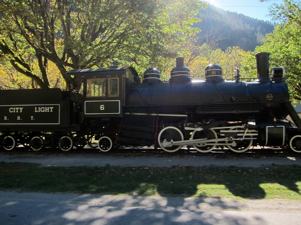
Seattle City Light locomotive along the North Cascades Hwy in Newhalem. I shot this with a Canon S95 while on the go. Not bad for 30mph, eh?
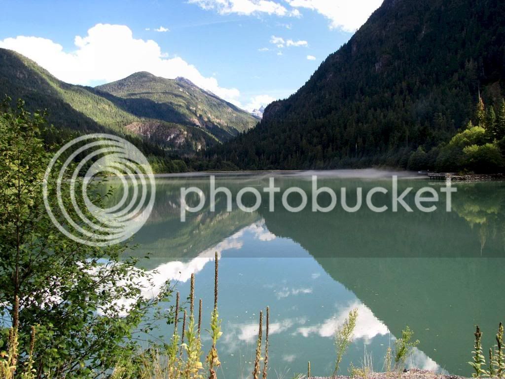
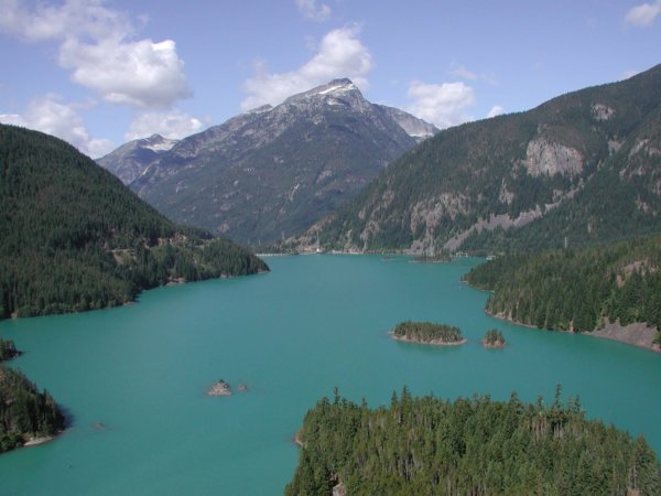
Diablo Lake from the Diablo Lake Overlook. I shot this photo in 2003. Yes the color of the water is turquoise.
After the Diablo Lake Overlook the road has about 10 miles of sweepers like this one. Perfect. I shot this photo in May 2007 and this is west bound.
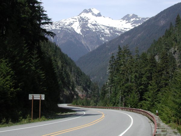
After the sweepers you approach Rainy Pass. This is a photo of the west bound view at Rainy Pass.
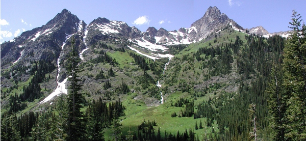
After Rainy Pass you drive by this stunning formation. It is always changing with the seasons. I shot this in Oct 7, 2012 on the go.
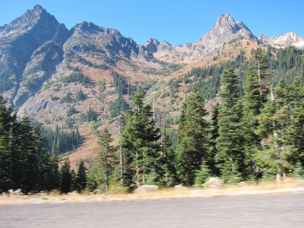
Same mountain peaks, same location. I shot this in July 2007
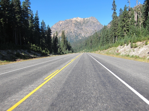
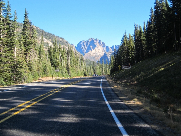
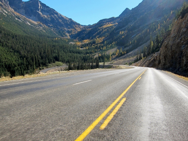
This photos is along the way to Washington Pass and the Big Loop.
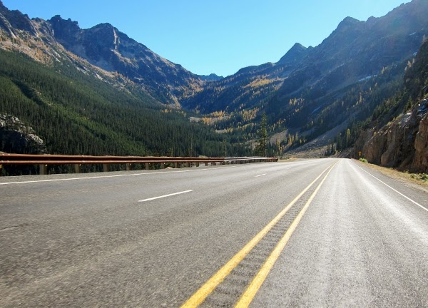
Washington Pass Summit and the descent.
Descending from Washington Pass Summit - photo taken on the go.
Descending from Washington Pass Summit - photo taken on the go October 7, 2012. You can see the Big Loop.
Descending from Washington Pass Summit - photo taken on the go October 7, 2012. You can see the Big Loop
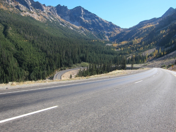
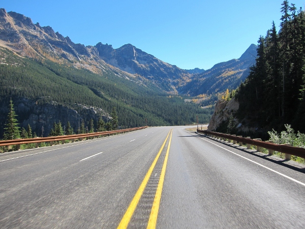
After the Big Loop, looking east. The Washington Pass Overlook is on the cliff, just above the road and trees on the left.
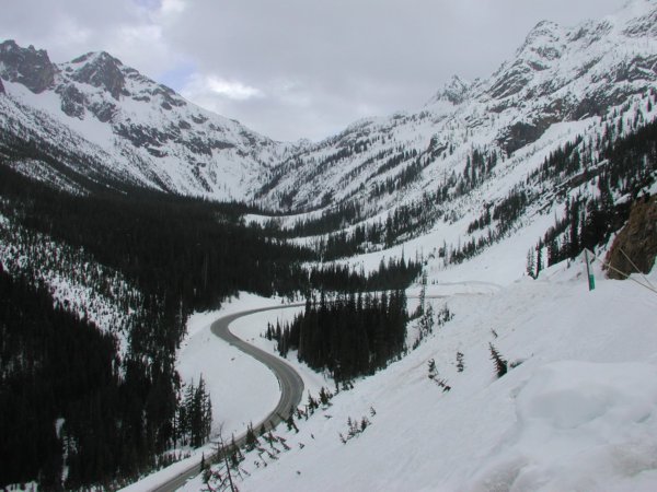
Of course the Big Loop looks different with the seasons. I shot this photo in May 2007.
From the Big Loop the road goes down to Early Winter and on to Winthrop, Washington. Winthrop is a western themed town where you can enjoy many outdoor activities and concerts. Fishing, cross country skiing and mountain biking are very popular. If you get over this way it is fun to have lunch Sun Mountain Lodge.
I stopped in Twisp to get gas with about 230 miles since the last fuel stop. I did not get off the bike. I road along Hwy 153 to the Columbia River and headed south to Wenatchee.
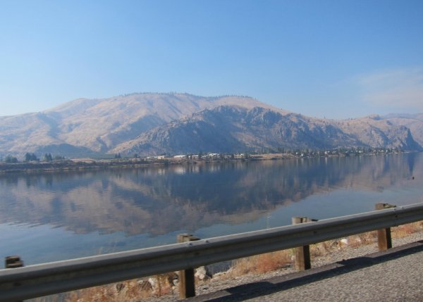
The Columbia River with smoky skies from forest fires in the mountains to the east. Shot this on the go.
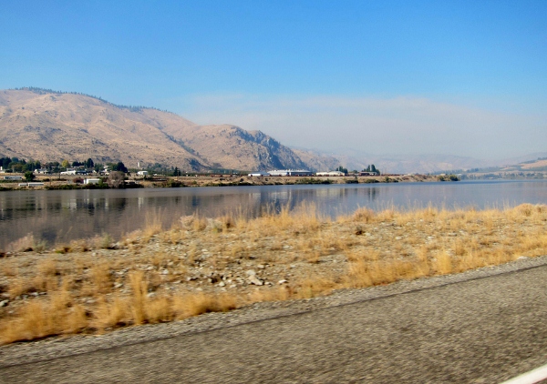
The Columbia River with smoky skies from forest fires in the mountains to the east. Shot this on the go.
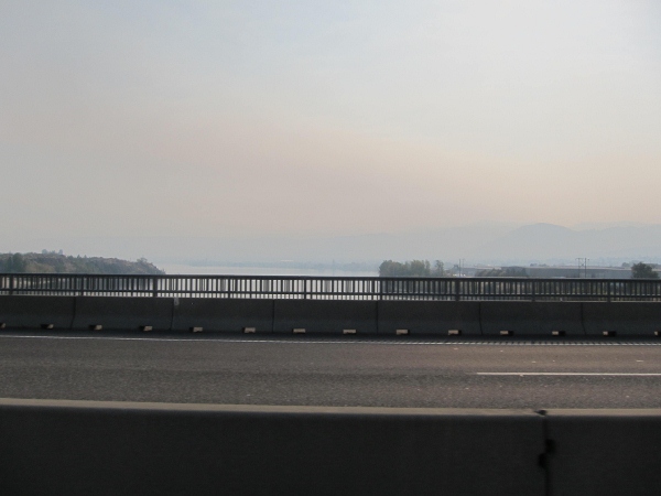
On US Highway 2 on the bridge over the Columbia River just north of Wenatchee which is completely obscured by smoke
It was smoky all along the river and beyond to Blewett Pass where it cleared a bit. I felt bad for the people who live here as it has been this way for weeks. The fires will continue to burn until they get a significant rain or snow fall.
I went over Blewett Pass and took I-90 home. Upon arriving at home I got my GPS stats.
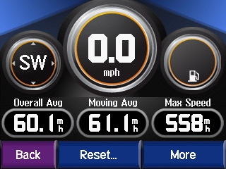
I road 436.2 miles.
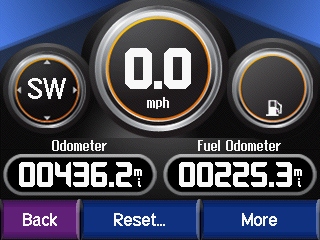
My overall average speed was 60.1mph. My moving average speed was 61.1 mph.
With a max speed of 558 mph the Gen II FJR is certainly faster than the Gen I.

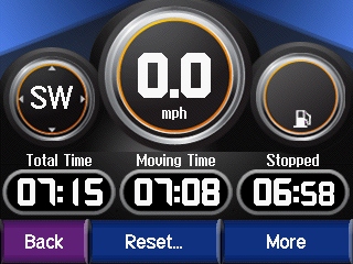
Total ride time was 7 hour 15 min. Moving time 7 hours 8 min and stop time was 6 min and 58 secs.
The End
It is a blue sky day and we start with a wife friendly departure time, about 10:00am. This works well as it has warmed up enough to keep her happy. Happy wife, happy life.
And speaking of the weather we having had a record dry spell going about 80 days with only .03" of rain. We north westerners (for Beemerdons Specific Northwetners) are giddy with delight, unless you live in a smoke filled valley down wind of a mountain fire such as Wenachee, Wa.
I had not been along the North Cascades Hwy since NAFO in June so it was time to get back before snow closes it for the winter. The time to ride in the low lands will come soon enough. Linda and I have been to Cascadian Farm for ice cream before so it is a easy bribe to coax her along, plus we get some fall colors along the way.
It was a great day of riding and on Sunday our plan was to go golfing. Sunday's plans changed about 8:30am on Sunday. The wife has arthritis and she is not up to golfing on Sunday leaving my day open. So I decide to head back to the North Cascades Hwy and do a loop ride. Why do it again?
Ah the North Cascades Highway. Only if all roads could be something like this. Going West to East the road starts off with a warm up out of Marblemount. Good tight twisties, the best ones, are right out of Newhalem, then let up a bit near Diablo and start up in earnest again to the Diablo Lake Overlook. There are a couple more tight turns after the Overlook, especially the decreasing radius turn at John Pierce Falls. This is the older section of road, pre 1968 and it shows in the tightness of turns and construction standards - yet the pavement is very good.
After the Ross Dam trail head parking lot there is a series of very nice sweeping turns for 10 miles or more. Just turn after turn after wonderful turn. As you approach Rainy and Washington Passes the turns give way, just a bit, to wonderful alpine mountain scenery.
North Cascades Hwy coming into Newhalem
North Cascades Hwy in Newhalem. Do not speed here!
Seattle City Light locomotive along the North Cascades Hwy in Newhalem. I shot this with a Canon S95 while on the go. Not bad for 30mph, eh?
Diablo Lake from the Diablo Lake Overlook. I shot this photo in 2003. Yes the color of the water is turquoise.
After the Diablo Lake Overlook the road has about 10 miles of sweepers like this one. Perfect. I shot this photo in May 2007 and this is west bound.
After the sweepers you approach Rainy Pass. This is a photo of the west bound view at Rainy Pass.
After Rainy Pass you drive by this stunning formation. It is always changing with the seasons. I shot this in Oct 7, 2012 on the go.
Same mountain peaks, same location. I shot this in July 2007
This photos is along the way to Washington Pass and the Big Loop.
Washington Pass Summit and the descent.
Descending from Washington Pass Summit - photo taken on the go.
Descending from Washington Pass Summit - photo taken on the go October 7, 2012. You can see the Big Loop.
Descending from Washington Pass Summit - photo taken on the go October 7, 2012. You can see the Big Loop
After the Big Loop, looking east. The Washington Pass Overlook is on the cliff, just above the road and trees on the left.
Of course the Big Loop looks different with the seasons. I shot this photo in May 2007.
From the Big Loop the road goes down to Early Winter and on to Winthrop, Washington. Winthrop is a western themed town where you can enjoy many outdoor activities and concerts. Fishing, cross country skiing and mountain biking are very popular. If you get over this way it is fun to have lunch Sun Mountain Lodge.
I stopped in Twisp to get gas with about 230 miles since the last fuel stop. I did not get off the bike. I road along Hwy 153 to the Columbia River and headed south to Wenatchee.
The Columbia River with smoky skies from forest fires in the mountains to the east. Shot this on the go.
The Columbia River with smoky skies from forest fires in the mountains to the east. Shot this on the go.
On US Highway 2 on the bridge over the Columbia River just north of Wenatchee which is completely obscured by smoke
It was smoky all along the river and beyond to Blewett Pass where it cleared a bit. I felt bad for the people who live here as it has been this way for weeks. The fires will continue to burn until they get a significant rain or snow fall.
I went over Blewett Pass and took I-90 home. Upon arriving at home I got my GPS stats.
I road 436.2 miles.
My overall average speed was 60.1mph. My moving average speed was 61.1 mph.
With a max speed of 558 mph the Gen II FJR is certainly faster than the Gen I.
Total ride time was 7 hour 15 min. Moving time 7 hours 8 min and stop time was 6 min and 58 secs.
The End
Last edited by a moderator: