


Jackson
Well-known member
I put together four routes that loop through the Black Hills. All of the routes start and end at Custer, SD.
You can just drag each map over to your desktop to save and print them.
(UPDATE: Sept. 18; Since some folks are going to ride the #3 route (Devils Tower, Northern Black Hills) the opposite direction, counterclockwise, I made a new route with this in mind, and deleted the original #3 route. The revised one is in a new post, #28, and it's called route #3c. I also modified it to now include some more excellent roads: Spearfish Canyon , Nemo Rd., and Sheridan Lake Rd. (SR-44).
(UPDATE: Sept. 11; I have revised the written directions so that they are much easier to follow. I have also created GPS files in the following formats: .gdb version 1, .gdb version 2, and .gpx
Send me a PM and I will send you a zipped file containing the directions and the GPS files. The written directions will be very useful for those with or without a GPS unit. They include turn by turn directions, tips about what to see, admission fees, gas stops, and suggestions obout where to eat. The zip file will not incude the .jpg's of the maps. They can be dragged directly off the messages, over to your desktop. From there you can print them.)
Here's some brief info:
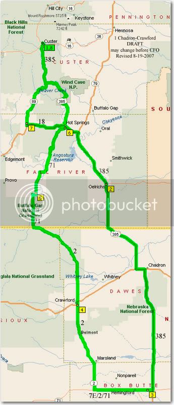
1. Chadron-Crawford
Miles: 272
Time: 6-7 hours, plus stops
Highlights: Wind Cave Nat’l Park, Southern Black Hills
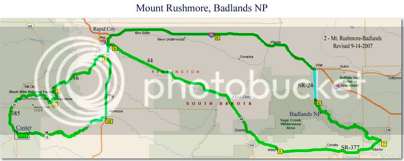
2. Mount Rushmore-Badlands
Miles: 244
Time: 5-6 hours, plus stops
Highlights: Mount Rushmore, Rapid City, Badlands National Park,
3c. Devils Tower-Nemo Rd (revised 9-18-2007; see post #28)
Miles: 286
Time: 6-7 hours, plus stops
Highlights: Nemo Rd, Devils Tower Nat’l Monument, Jewel Cave Nat’l Monument, Spearfish Canyon, Sheridan Lake Rd.
4. (deleted)
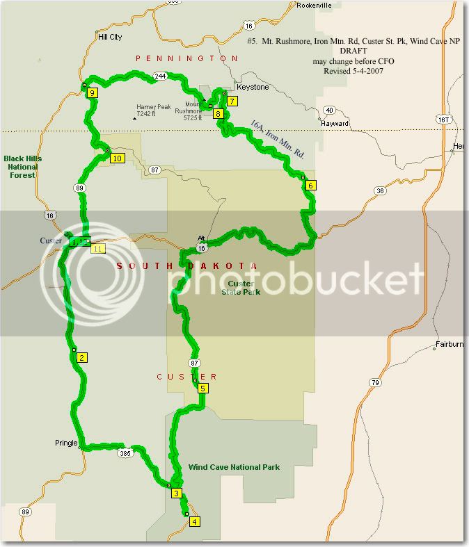
5. Mount Rushmore, Iron Mtn. Rd, Custer St. Pk., Wind Cave Nat. Park.
Miles: 90
Time: 2.0 – 2.5 hours, plus stops
Highlights: Mount Rushmore, Iron Mtn. Road, Custer St. Park, Wind Cave Nat. Park.
Here is the first one. #1, Chadron-Crawford
The other routes are in additional posts.
You can just drag each map over to your desktop to save and print them.
(UPDATE: Sept. 18; Since some folks are going to ride the #3 route (Devils Tower, Northern Black Hills) the opposite direction, counterclockwise, I made a new route with this in mind, and deleted the original #3 route. The revised one is in a new post, #28, and it's called route #3c. I also modified it to now include some more excellent roads: Spearfish Canyon , Nemo Rd., and Sheridan Lake Rd. (SR-44).
(UPDATE: Sept. 11; I have revised the written directions so that they are much easier to follow. I have also created GPS files in the following formats: .gdb version 1, .gdb version 2, and .gpx
Send me a PM and I will send you a zipped file containing the directions and the GPS files. The written directions will be very useful for those with or without a GPS unit. They include turn by turn directions, tips about what to see, admission fees, gas stops, and suggestions obout where to eat. The zip file will not incude the .jpg's of the maps. They can be dragged directly off the messages, over to your desktop. From there you can print them.)
Here's some brief info:
1. Chadron-Crawford
Miles: 272
Time: 6-7 hours, plus stops
Highlights: Wind Cave Nat’l Park, Southern Black Hills
2. Mount Rushmore-Badlands
Miles: 244
Time: 5-6 hours, plus stops
Highlights: Mount Rushmore, Rapid City, Badlands National Park,
3c. Devils Tower-Nemo Rd (revised 9-18-2007; see post #28)
Miles: 286
Time: 6-7 hours, plus stops
Highlights: Nemo Rd, Devils Tower Nat’l Monument, Jewel Cave Nat’l Monument, Spearfish Canyon, Sheridan Lake Rd.
4. (deleted)
5. Mount Rushmore, Iron Mtn. Rd, Custer St. Pk., Wind Cave Nat. Park.
Miles: 90
Time: 2.0 – 2.5 hours, plus stops
Highlights: Mount Rushmore, Iron Mtn. Road, Custer St. Park, Wind Cave Nat. Park.
Here is the first one. #1, Chadron-Crawford
The other routes are in additional posts.
Last edited by a moderator:
")