Jaugie
Well-known member
Well the one from Yesterday that was headed to the Bay area has just fallen of the tracking page..


I just noticed that too. Any ideas?Well the one from Yesterday that was headed to the Bay area has just fallen of the tracking page..
I wonder if that was one of the DNF riders making their way home. The device time zone on the Spot was Los Angeles.I just noticed that too. Any ideas?Well the one from Yesterday that was headed to the Bay area has just fallen of the tracking page..
I just noticed that too. Any ideas?Well the one from Yesterday that was headed to the Bay area has just fallen of the tracking page..
Great map, my first though - "What! No Key West sucker bonus?"In case any of you are wondering what all the bonus locations look like plotted on map at once . . .
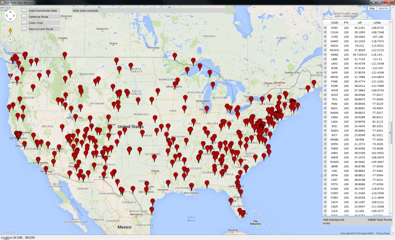
My nerd side came out with the release of the bonus locations. I copied the text out of the file, then wrote a little program to parse out the codes and latitude/longitude from each entry. Then I pulled that data into my TSP in Google Maps program, to display all the locations on the map.
Here is what it looks like, with all the locations in the lower 48 shown. (click on the image for the full-size version if you want it bigger)
Since many run sat radio the Garmin 665 can display XM weather radar, For those with the 478's get true NEXRAD radar also via XM. There are smartphone apps as well for the budget conscious, although that usually requires stopping and playing with the phone.Riders currently east and south of Memphis are getting drenched. https://radar.weather.gov/radar.php?rid=NQA&product=N0R&overlay=11101111&loop=yes or here: https://radar.weather.gov/Conus/southmissvly.php
For those with multi-day rally experience, how do you track weather while on the road? With a "playing field" the size of North America, riders could miss all that rain by bagging upper midwest locations or maybe New Orleans and Mobile locations.
Original Post~snip~ I copied the text out of the file, then wrote a little program to parse out the codes and latitude/longitude from each entry. Then I pulled that data into my TSP in Google Maps program, to display all the locations on the map.


This morning's IBR report says that Mark Starrett decided to throw in the towel and head for home yesterday morning. Perhaps the CA rider is him?Day 6 has been posted. "I tried sitting in McQueeney’s seat once and he went all Sheldon Cooper on my ass." Bwah!!!!
As far as the CA person out in the wilderness and then not on the page anymore...maybe they purposely exercised their option to not be on the page anymore. Would seem like a great time when their farthest from the pack to then run silent and mysterious.(Edit: Although it would seem to NOT be my guess, Barclay, as he was reported as heading to Texas with others in the dispatch)
Love Mr. Cimino's sense of humor and word selection. Another example: "Crane goes to great lengths to avoid Mississippi like a man who owes alimony. "Ignacio posted: Day 6 has been posted. "I tried sitting in McQueeney’s seat once and he went all Sheldon Cooper on my ass." Bwah!!!!
Really cool stuff you're doing grommet. Got your note and we'll share some thoughts. thumbs-up.Thanks for all the likes, folks.
I have some more ideas. The file I made is not a gpx file. It's actually in the same format the riders get the location/point data in. Or very close to it, IIRC. I got a copy of such a file from a rider in 2013, and used that as an example. The idea was to be able to plug the data from the IBR staff directly into the software without doing anything to it first. to make the initial routing fast and easy.
Anyway, a gpx file is not too complicated. I have never worked with them before but they are just their own flavor of xml. An xml file is just a text file with special tag markers in it. The process would be helped if a couple of you could send me examples of gpx files you have. Simple ones, with a few waypoints in them. There are some examples on the web, but making something exactly like what you have will be easier if I have somewhere to start. email them to me at patrick at exactcad dot com.
I'll also be starting a thread about the whole thing so as not to clutter up this thread with it. Can someone tell me where to put such a thread? Thanks.
Last night I saw a guy approaching Wichita from the southwest. I rode out to meet him, rode across town with him, and sent him on his way up I-35 toward Emporia and KC. I think it was Gregg Lenentine. When I asked his name, he said it was Greg and he was on a silver FJR. That's the only Gregg on an FJR in the rider roster. Nice guy, seemed to be in good spirits and doing well. Handshake and a thumbs up and on down the road he went.
Enter your email address to join:
