Three Flags Classic - 40th

Yamaha FJR Motorcycle Forum

Help Support Yamaha FJR Motorcycle Forum:

This site may earn a commission from merchant affiliate links, including eBay, Amazon, and others.

sapest

Well-known member
Joined
Aug 24, 2012
Messages
629
Reaction score
520
Location
Vancouver BC Canada
Leaving home, I first rode from Vancouver BC to Shasta Lake, and stayed there a couple of days. The journey continues south;

Shasta Lake to San Diego

The good news is that LA traffic didnt kill me.

The bad news is that I had to drive thru LA traffic.

I bypassed most of LA, going east, then south. I thought getting past LA after rush hour would be better than the next morning during rush hour.

Not much else to report. I-5 from Shasta south is boring, always under construction and hot. 35C @ about 6 pm.

Oh, I did see the Oscar Meyer weinermobile just past the Merced exit.

Heading north.

I stopped at iHop for a bowl of soup.

While I was enjoying sitting down on a seat that isnt moving, I see the staff is hanging a sign on the door.

The good news - my bill had a seniors discount. (H'mmm maybe thats not good news )

The bad news - the sign on the door says 'we are closed tomorrow for pest elimination'


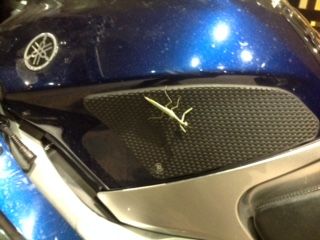
This guy escaped the purge!

Calmer today, chores and eating, as it turned out.

I walked out to the bike in the morning and found a column of ants running up the kickstand and into the guts of the bike. Seat, dashboard, gas tank, they are everywhere. Fired the engine and let the bike warm up for about 5 minutes. For the rest of the day I was seeing baked ant here and there on the bike.

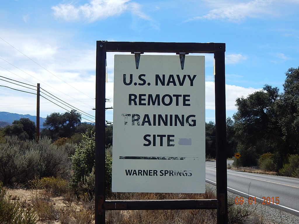
I left Lake Elsinore and headed for Julian, (possibly) world famous for apple pie. Hiway 79, about 75 miles. Curvy. And it climbs to about 4200'. On the way, I passed the entrance to the Navy Survival School. This the level C training spot, where the SEALS, RECON Marines, snipers and other hardcore go.


I guess cutbacks means they cant repaint their sign.

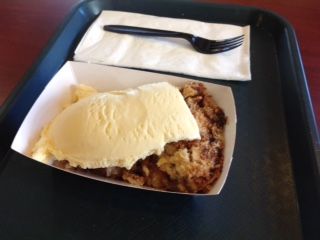
Lunch was apple pie with crumble topping and ice cream at Apple Alley Bakery. Yummy.


While I was eating, I overheard the following order;

"Can I have a vegetarian sandwich, and can you add turkey?"

I did have a tough time not falling off my chair.

Onto San Diego, about 60 miles. Coming down off the mountains and back into the heat. Crossed the city limits at 1 pm.

Found the hotel. Did laundry. Bought a few groceries. Found free parking (broken meter) in the 7th most expensive US city to park in.

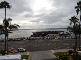
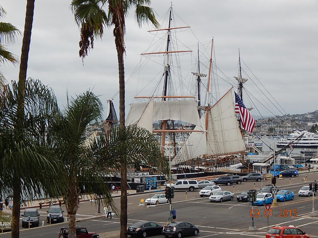
View from balcony, I am on the 4th floor;

To my left is the USS George Washington, one of the monster Nimitz class carriers. That's about 5500 navy and aircrew in town.


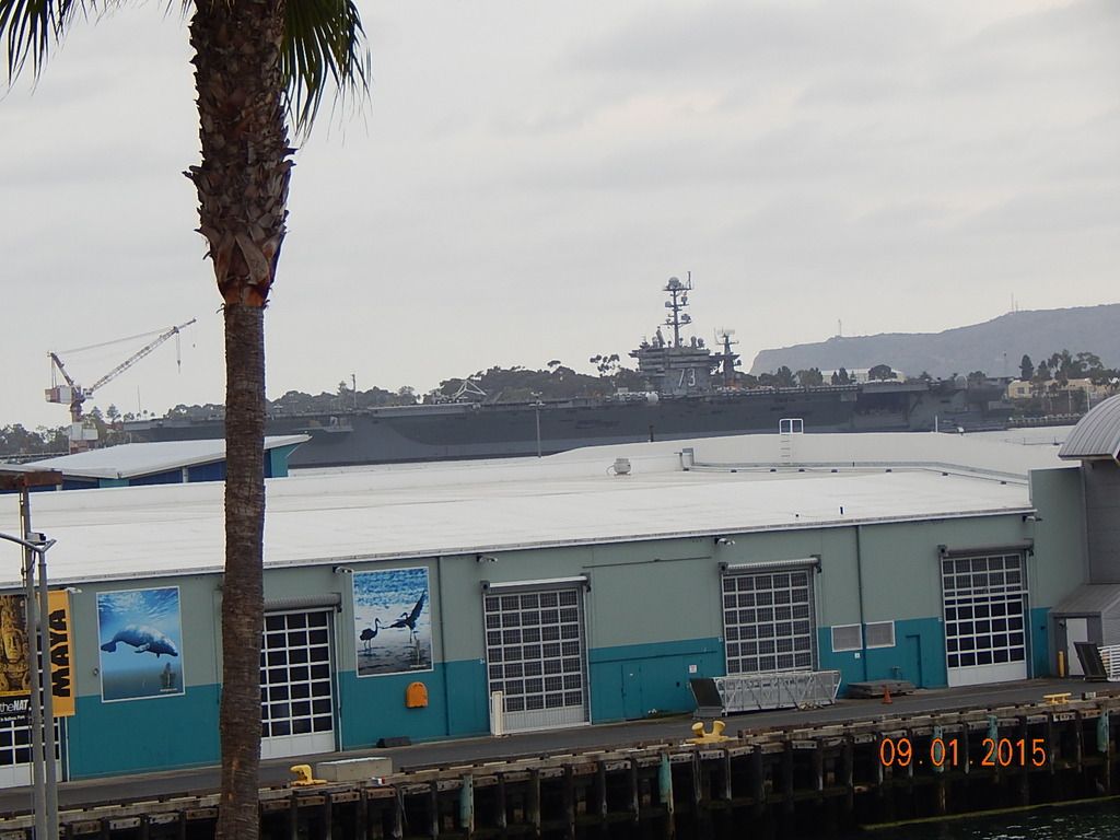
Right in front is the harbour;


To my right is a sailing ship, a submarine and some harbour cruise ships.


Took a walk into Little Italy, found Bencotto, and had Crespelle Alla Genovese. Crepes, pesto, fontina cheese, and green beans.


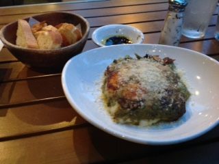
Sat outside, watched the beautiful people of San Diego walking their dogs and enjoyed the sunset. Best meal of the trip.

Up early tomorrow for the 'Touch the Fence' ride.

 
T'was the night before . . . .

In San Diego

Today started with the 'Touch the Fence" ride.

About 15 miles south of the hotel is the US/Mexican border at San Ysidro. We were to meet at the Outlet mall at the border. We were greeted by a young Mariachi band.


Then there a couple of speeches, the border guards raced their ATVs between the fences, and pastries were consumed. Here are a couple of shots of "the fence".


This 3.5 miles of fence is reported to have cost $58 million in 2009. Very high security.

Except for the screen door section, I guess that cost a lot less.


On our own after that, I had breakfast at Aichote. No photo, I forgot.

Then I rode over the Coronado Bay Bridge, and back to the hotel.


Walked to the post office to mail some things home I didnt want to carry any longer. 5 lbs worth!

Poor banquet at 5, speeches and last minute warnings and changes, mostly due to the various forest fires, followed by a 'First time riders meeting'.

Early to bed, must leave between 3 and 6 am.

Next stop is Oakhurst CA. 500 + miles.

-Steve

 
San Diego to Oakhurst CA

Left this morning at 5 am. Wanted to get beyond LA before the morning rush. I think I was in the last 20% of bikes to leave. Immediately messed up my instructions, and went about a half mile the wrong direction.

About Riverside, traffic slowed to a crawl. While I am stopped a Highway Patrolman on a bike passed me by, lane splitting (or lane sharing as they call it here). So I followed him. For about 10 miles. Just magical, people actually move over so we could get by. Not because of me, of course. It worked very well. Still scary, dont think I would do it on my own.

More freeways and then onto some secondary highways. Its about 8:30, I am beyond LA and I stop for 'brunch'. Something called a California omelette.


Past Bakersfield, and then north and into the slower curvy stuff inside the Sequoia Forest.


Saw the General Sherman tree. Its a good size. I would put the cedars in Cathedral Grove (on Vancouver Island) up against these trees any day. It was nice and cool, elevation was around 6500'. Saw a tarantula walk across the road. There are so many tarantulas here that they have a festival in a town called Coarsegold. (Next town down the highway) Then down into the Fresno furnace.

And back up in elevation (2200") to Oakhurst, the "gateway to Yosemite".

There are deer on the motel grounds, saw them twice (mom and two fawns), but they were gone by the time I got the camera.

Tired, its going to be an early night. I think today was just over 500 miles.

-Steve

 
I can see for miles and miles . . .

Oakhurst to Alturas CA

I am in Alturas CA. Its a small town. How small? The pizza delivery guy walks to make deliveries. Oh I wish had the camera when he walked by me, cause I know you wont believe.

I left Oakhurst about 7:30 am. There were maybe 10 bikes in the lot. Why so late? I was tired, I knew that a lot of todays roads were one lane winding bits,(so leaving later I would miss the 'traffic') and I knew we would be going up in the mtns, and it would be cold, getting there later in the day should be warmer. Oh, & I was tired, did I mention that?

Todays morning route was thru the Sierra Nevada's, national forests, and wilderness areas. Lots of curvy bits too.

Some morning scenery shots;


Look carefully and you can see the road I am about to be on.


I think this what is left of the Merced River


Dam on same river

Climbing, climbing, climbing to Sonora Pass. And it was cold, like 11C.


Yes, 9628 feet elevation!

Of course, now we have to get down the mountain.

There are some really steep bits, one is a !25%! grade, another is only 15%.

This photo doesn't really suggest how steep the first grade, maybe 20%, really is.


Plse note the "cows on the road" sign. This just adds to the excitement.

Speaking of excitement, there were crazy people on bicycles riding up to the pass. Then they turn around and ride (fly?) back down to their vehicles.

The highway bottoms out in Pickle Meadow, home to Marines Mountain Warfare Training Center. No stopping, no photos.

At this point I chose a different route than the suggested one. For a number of reasons I took CA 395 north, thru Reno, and onto Alturas.

The first bit is very scenic, lots of trees, etc. You even cross into NV for a short while and then back into CA. At Minden the highway turns 'real', multi lane and divided all the way to Reno. It was a bit windy. (Crosswise) After Reno is the Washoe Valley. And I thought it was windy before. How windy was it? Trucks, campers and RV's were being stopped and turned back to Reno. I think I drove about 18 miles with the handlebars about 8 degrees left.

After that bit of fun, its pretty flat farmland. Emily (GPS) started warning me about dust storms and rain.


This dust storm, as near as I can figure is blowing across what used to be Honey Lake. No water now.


Correct twice in a row! What a surprise.

The dust storm I just hit the edge of. The rain storm started to chase me in Alturas.


Dust storm boots.

The rain storm was getting bigger in my mirrors. Stop for rain gear or beat the storm into town?

The FJR cruises just as smooth at 90 as it does at 65. Does that answer the question?

About a minute after I pulled into the checkpoint, the storm arrived, wind, rain and hail. Today Mother Nature didn't get me wet.

I saw a triple dump truck, the truck and two pups. That's a lot of gravel.

I am staying at the Hotel Niles. Its one of those historic downtown charming type of hotels. No phones in the rooms. No TV's either. I have a themed room, the "Hobo Junction".


In my head, all I can hear are the lyrics to King of the Road - "rooms to let - fifty cents".

I guess hobo's never hang up their clothes.


Maybe thats why there is an ironing board?

Dinner was Mexican, as the troops filled the Italian place which was closer.


Enchiladas de la Crema. Yummy.

I think tomorrow will separate the men from the boys. The easy stuff is over. Alturas has a frost warning for Sat morning, its supposed to be raining all day in Lewiston (tomorrows destination) and the journey is about 540 miles. Yikes!

-Steve

 
Baby it's cold out there . . . .

Alturas to Lewistown

Its funny how your scale changes. Today I found myself thinking "only another 200 miles to go". I have been on rides that are not 200 miles total!

Alturas, home the Sheepdog Nationals in about two weeks, was cold this morning. I knew it would be, so I delayed leaving to 7am. I wanted to be sure there wouldn't be any ice on the road.

I uncover the bike, and the TPMS warning lamps are lit up. The monitor indicates both tires are 5 lbs low. I'm going to give it 5 km to see if the lamps go out, after the tires warm. Really hoping that's all there is to this. (& I was right)

In any case, the bike reported 0C on startup. Not a number I wanted to see. Got moving right into a number of fog banks. Then it was -1, then -2, and finally -3.

So now it was just a case of staying warm. Heated gear, and grips, close all vents, etc. The only thing not warm were my toes. The temp remained below 5C until 11 am. Therefore there are no photos until after that. The trip thru the rest of CA and into OR was impressive. Terrific scenery. But 5000+ ft of elevation kept the temp down. Finally out of CA and into another state!

Just before Canyon City I rolled thru the Canyon Creek Summit and into the scene of the very recent fire. So recent that the road was still stained with the red fire retardant that is dropped from airplanes. Burned piles of trees, and worst of all, heaped up remains of homes were on both sides of the highway for about 5 miles. Very sad.

Past Canyon City, and into the John Day River Valley. Lots of 'Oregon Trail' history in the area:


Lots more spectacular looking scenery, but I needed to warm up again.

Out of OR and into WA. Third state in the same day. More great scenery.


This is Joseph Canyon.

Todays roads were very FJR friendly, more broad sweepers than tight twisties. Lots of fun.

After hitting 13C, the temps began to fall again in the late afternoon. I arrived in Lewiston about 5:30, again being chased by HUGE raincloud, with the temp around 7C.

Everyone arriving 10 minutes after I did was soaked.

Canada tomorrow!

-Steve

 
Home again -

Lewiston to Kamloops

Two eye poppers to start the day. It was 4C in Lewiston when I got on the bike. And the first part of the route was on the "Old Spiral Highway" out of town. I was really awake by the time I merged onto the new highway.

There are no photos for two reasons;

With one exception, there was nothing 'special' to photograph.

Today was about making miles and the checkpoint before it closed. There was no time for photos. 537 miles, one border, one mandatory gas stop and one ferry. Except for those stops and gas I was never off the bike until the checkpoint in Kamloops. Checked in with 40 minutes to spare.

That's not to say the ride wasn't pretty. After Lewiston, eastern WA is one grain farm after another. Like a hilly Sask. After Spokane the route followed the Pend Oreille river valley and into BC at Nelway. Lots of hills, mountains and pine trees. Thru the Monashee Pass and into Vernon, after the Needles 10 min ferry ride. Then into Kamloops.

Good quality BC scenery.

The border took about 30 minutes, two guys, one computer. And they knew we were coming, they had a registrant list. No wait for the ferry, just good timing. Not too much construction either.

The one thing I should have taken a photo of - I saw a turtle walking across Highway 97 near Monte Lake. A turtle as big as my hand. There was a big pond on the side of the road, I guess that's where he was headed. Took the Barnhart Vale Rd (its got a DH #) into Kamloops, off route but well worth it. Kamloops checkpoint was the HD dealer, who put on a great spread, lots of food, cake, fruit, etc. Kept the store and service open for Three Flag riders too. Very nice!

I'm headed for Vancouver Island. Holiday Monday traffic - should be interesting.

 
Chasing the sun to Victoria . . . .

Kamloops to Victoria

Mea culpa - I broke the first rule of long distance riding; I went home during the event.

When I first saw the route, I promised myself that I would not do the Duffy Lake portion (Highway 99 thru Squamish/Whistler and Horseshoe Bay) if it was raining. Leaving Kamloops in the rain this morning made my choice simple. Highway 5, 120KPH speed limits and no traffic on holiday Monday. Surrey Summit was 4C. The rain was in nice spaced bands, just as I dried out, I would ride into the next bit of rain.

Instead of photos; picture your favorite 4 lane divided highway. Add rain. Add lots of trees on both sides of the road. Add a bit of standing water in the roadway. Add grey/dark clouds hovering just above the treeline. Make the temp around 4-6C. There you go, welcome to the first hour of today's ride. The Nicola Valley was half in the rain, and half in the dry. Halfway to Hope the rain slowly tapered off, and by Hope it was dry and there was blue sky.

Since I was taking the Tsawwassen ferry, I was going to ride by the house, and that's where I ended up about 10:00 ish. Stopped in for a hug, a real cup of tea and dumped off some dirty clothes and other stuff I wont need for the rest of the journey.

Left the house just before 11 and took the new highway 17 to the ferry terminal and made the noon ferry, even after stopping for fuel.

Here's a few 3 Flaggers on the ferry -


Yes many, maybe half the participants ride Hondapottamus's. Sadly there are a number of riders who don't make their Gold Wing look big.

Arrived in the sunshine, and here are some more participants at the Empress Hotel check in;


There are 300 to check in, so its check in and get out!

Today I met a fellow from Honolulu, it cost him $900 to ship his bike, both ways, and its a week in transit.

Critter count = one tarantula, one turtle, a number of deer, one bunny, one coyote, one dog, and a big angry bird that thought my helmet might make good eating.

Dirty bike - (& this is after the rain scrubbed a lot off)


Cleaner, but not clean bike -


The hotel provided a hose and bucket. There were some amused tourists watching me wash the bike in the hotel courtyard.

I rode 3737 Three Flag km's. (2335 miles) The official route was 3885 km's, 2414 miles. I have heard others had a far harder time, snow, traffic south of Nanaimo, and various mechanical and tire problems. Thx to the FJR platform and the pro's @ Daytona Motorsports, I had no mechanical issues.

All for this belt buckle;


While I like the "Palms to Pines" theme, I doubt I will ever wear it.

In 11 days I have travelled a total of 7345 km's (4590 miles), thats 668 km's, (417 miles) per day.

Tomorrow is the banquet, where the stories get told and there is much thanking and clapping.

-Steve

 
Outstanding RR. Being a food whore, I especially enjoyed the food porn photos!

Glad that you had a chance to sample some of my favorite roads, eat pie in Julian, and experience "lane sharing" with an escort. We who have decades of practice wonder how the rest of the country live without the option.

I live about 75 miles north of the USA/Mexico border. When I read that you left San Diego at 0500, with hopes of avoiding rush hour traffic... I knew what would come next. (When I ride up to the Bay Area, I leave here at 0400 and don't stop for fuel/coffee until I'm about

100 miles past Lost Angeles.)

Thanks again for the report.

 
Last edited by a moderator:
Happy to hear you enjoyed this RR. This website does not make it easy to post pics.

And food porn should be required in any multi day RR :)

I am still too new to this forum to understand how group rides get organized, but this event cries out for some major FJR participation. You can ride alone, or in a group. You can build your own route or use the one provided. (Bonus = you can dwnload a file for your GPS with the suggested route and all checkpoints) You can stay in hotels (of your choice) or camp. And you get to see some pretty darn good scenery in two countries.

-Steve

 
Well you've definitely got the food porn thing down pat!! Surprised you didn't take any pictures of the giant trees.

That curved bridge over the bay would be neat to ride, I think.

Thanks for sharing your trip with us.

 
Thx.

Anyone visiting San Diego area on a m/c needs to include a ride over the Coronado Bay Bridge and to Julian for pie. Add Otay Lake Rd for a trifecta. (Take a tour of the US Olympic training facility nearby)

I guess I take big trees for granted, just like big mountains. BC has lots of both. Or I can always head to WA for some US versions of the same thing :)

-Steve

 
Top