The Alps - or 8 countries, 9 passes in 7 days

Yamaha FJR Motorcycle Forum

Help Support Yamaha FJR Motorcycle Forum:

This site may earn a commission from merchant affiliate links, including eBay, Amazon, and others.

mcatrophy

Privileged to ride a 2018 FJR1300AS
Joined
Aug 25, 2006
Messages
4,332
Reaction score
1,824
Location
Derby, UK
Preamble

I've been wanting to do an Alpine trip for years, but it's not easy to do without some pretty boring riding.

Possibly because I may be coming to the end of my motorcycling career (a significant heart operation impending, and glaucoma affecting one of my eyes), my good riding friend R organised this little trip. There were three of us, R, my son, and me. No-one else was invited, we knew that we would be covering a lot of ground fairly quickly, and a larger group would inevitably lead to delays in keeping the group together, and we needed to "make progress".

Timing was also an issue. Son was committed to an event, running up hills for charity (sometimes I can't believe he is my son) on the Saturday, I have a hospital test on the Monday week. We didn't want to delay because later in the year the weather can close the passes we wanted to do.

R decided a route, and booked hotels. He's very good at this sort of organising, and knows most of the passes we would be riding, though he'd never done such a concentrated event.

So, Son gets home on Saturday approaching midnight, we need to set off at 7:30 in the morning. He is going to be tired. Oh, well, he will recover. He made sure his bike was packed before he went off on his little exercise.

My preparation? Friday I decide to check my tyre pressures. Look at my rear tyre - yes, that's got a couple of thousand miles left in in it. Front tyre? Oh, less tread than I thought. And it might rain. And I'm going to be riding in the mountains. So, ring up my local tyre supplier, "Have you got a front tyre for me?" "Yes, I'm looking at a BT023." So, whip the wheel off, newspaper in the boot of the car (it's still "her" car, so I daren't get it dirty), in goes the wheel, and I have a nice new tyre on the wheel in short order. Put the wheel back on the bike, and as I fiddle the brake callipers to get them on, I notice the depth of the pads. Not exactly worn out, but I will be doing some braking in the mountains, possible heavy and prolonged. So, ring up my dealer, "Have you got some brake pads?" "Yes, in stock." So, jump in the car, round to the dealer. Brings out the pads. They're EBC. I really would prefer Yamaha, but that's all he has. Ok, they will have to do, and I install those. Now the bike is ready. I spend Saturday getting my laundry up to date and packing, ready for the Sunday 7:30 start.

Day 1, Derby to Pontavert

In the past, we've generally used a ferry to get to the Continent. this time, we decided to meet in France, and because of Son's running commitment, the only way we could get to the continent in time was using the Eurotunnel railway shuttle. R (who lives on the island of Guernsey) would go by ferry directly to France, we meet up at our first hotel. So, Sunday at 7:30 son and I head for Folkestone to catch our train.

Because we'd allowed for contingencies (traffic, roadwork, accidents), we had one of the best motorway runs I've had in years, we arrive a couple of hours before the train we are booked on. So, we can get on an earlier train. This means a better arrival time (read: more bar time) at the hotel.

(Click on any image for a larger view, clicking on a route image will give you an interactive map)

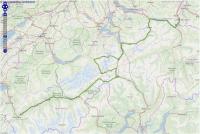
Bikes parked in the train.              The morning route.


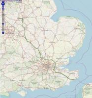
35 minute trip (plus riding on and off we are in the last carriage and have to wait while all the cars in front move out), and we are in France. Then, it's motorways, mostly toll (peage) roads to our first hotel near Pontavert, where son and I meet up with R.

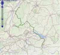
First day's stats.                            The afternoon route.
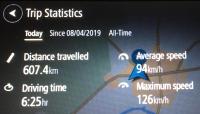


607.4 km


=


377.4 miles


94 km/h


=


58.4 mph


126 km/h


=


78.3 mph

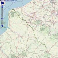
Day 2: Pontavert to Chambéry

Today was another slog along French motorways, again, mostly peage. It's the only way to cover ground in France, but it is expensive. Good run, no problems.
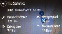


721.3 km


=


448.2 miles


97 km/h


=


60.3 mph


144 km/h


=


89.5 mph

Countries so far: England, France.

To be continued. (That's the first boring bit out of the way.)

 
Day 3: Chambéry to Fully

Today is the first of the fun days. We head south, east then north, hit the Col D'Iseran (to Val D'Isere). We cross into Italy via the Petit St Bernard, followed by the Gran At Bernardo into Switzerland. The roads are all you could ask for if you like twists and turns. I would encourage you to click the route map below, follow it, expand it. The zigs and zags are challenging, but the roads are well kept and have plenty of grip. As I've said many times before, I'm not a peg scraper, but I did rub my boots a few times, but never felt insecure.

We didn't stop often, but a few pictures.

(Click on image for larger view)


382.5 km


=


237.7 miles


58 km/h


=


36.0 mph


137 km/h


=


85.1 mph

Passes today:

  • Col D'Iseran (to Val D'Isere)
  • Petit St Bernard (into Italy)
  • Gran At Bernardo from Aosta to Switzerland, then Martigny to Fully
Countries so far: England, France, Italy, Switzerland

To be continued.

[edited to correct route link]

 
Bastard.  It's been almost two months since I returned from my European adventure.  But writing a ride report for 60 days in Europe is such an insurmountable task, I doubt I'll ever get it done.  I am enjoying yours.  Reminding me of good times had, and good times yet to come.  Bravo!

 
Thanks for the pics and ride-along mcatrophy! Looking forward to the rest of the trip.

Sorry to read about your medical issues, hope the Docs get you squared away.

~G

 
Just to whet appetites, here's a part of Day 3's route:


Day 4:  Fully to Triesen

Today was more passes and more countries.

Pictures, as usual, cannot do justice to the views, but here are a few:

There's snow in them there hills, and motorcycles hiding in the dark


Some of these show electricity power lines, there's a lot of hydroelectric power generated in these mountainous regions.

One of those zig-zag roads.         A bit of zoom


Zoom right of centre.                    And how they ease some of the twists


There were quite a few birds using the updrafts (visible in this full-sized picture)


Son wanted a better view for his photo


There was, of course, lots of water


Some of it coloured by its feeding glacier, and its level above some of the clouds ...


... as were we


That cloud covered our last pass, made going down a bit hairy, visibility was just a few yards. R, leading, found a car to follow. Son and I followed the tail lights of the bike in front. Unpleasant, knowing the drop-offs just off the edge of the tarmac. We stopped once at a viewpoint, R assured us that, had there not been this fog, the view was the best of any. Typical.


430.5 km


=


267.5 miles


58 km/h


=


36.0 mph


133 km/h


=


82.6 mph


Passes today:

  • Nuefenen (Novena) to Airolo
  • San Gottardo to Zumdorf (tunnel)
  • Furkapass to Gletch
  • Grimsel to Boden
  • Sustenpass eastwards to Wassenthen up to Altdorf for ...
  • Klausenpass (fog)
Countries so far: England, France, Italy, Switzerland, Liechtenstein.

To be continued.

 
Day 5: Triesen to Baden Baden.

Well, the interesting stuff is over. We have two days to get to our ferry. First leg into Germany, however we are passing near the border with Austria. "Shall we make the detour?" asks R. "Of course" we both reply. So, we divert, cross into Austria (border police have no interest in us), turn round, back into Liechtenstein, and into Germany.

Lots of traffic. We go onto (famously) de-restricted autobahns, but don't push the speeds, there's little point, and the traffic is heavy enough to make it uncomfortable. So, moderate speeds it is.

We stopped once overlooking the Bodensee (as the locals call it) or Lake Constance (as the rest of the world calls it).


Not a very good vantage point.

Not much else to report, just motorways and contending with traffic.


442.5 km


=


275.0 miles


58 km/h


=


36.0 mph


148 km/h


=


92.0 mph

Countries so far: England, France, Italy, Switzerland, Liechtenstein, Austria, Germany.

Day 6: Baden Baden to Zeebrugge.

Just eating miles to catch our ferry. R's bike was causing him a problem, his clutch was dragging, changing gear was difficult. When we came to board the ferry, inevitably a slow performance, he was having real problems, so pushed it for much of the booking-in process. More of this later.

Never having been on this ferry before, I was somewhat surprised to find we had to strap our bikes down ourselves. Straps were provided, but the hawser running the length of our lane was pretty slack, and, as people adjusted their straps, the tension came and went. Most unlike the ferry I'm used to, from Plymouth to Santander, where the staff are responsible and do a pretty good job.


596.2 km


=


370.5 miles


90 km/h


=


55.9 mph


144 km/h


=


89.5 mph

Countries: England, France, Italy, Switzerland, Liechtenstein, Austria, Germany, Belgium.

Day 7: Hull to Derby.

The ferry crossing was unremarkable, smooth (for which I was grateful, considering my bike-strapping comments above). Arrived before the due time, docked, but weren't allowed to disembark until the official time, presumably because of the immigration people.

The motorbikes were last off, and inevitably, I was in a queue where someone took ages to be allowed in. I was pretty much the last out of the dock. R rode his bike off the ferry, but having joined the immigration queue, he pushed the bike to the immigration kiosk. Son kept with him, mostly to make sure no-one ran into the back of him (I was put in a different part of the ferry, so was a bit away, couldn't provide any support).

We had arranged that son would accompany R to a Ducati dealer not too far away. They left the dock long before I did, so I went straight home.


Comments.

My trip stats:

Total miles: 2072 (GPS), 2121 (odometer).

MPG (not including the last 150-odd miles): 56.79 (Imperial), 47.28 (US), which I thought was pretty good considering some of the riding we were doing.

Weather:

Temperature varied between about 6C and 35C (43F and 93F). Apart from our foggy bit, it was always sunny and bright, couldn't have wished for better. For the cooler tempertures, a fleece under my jacket was sufficient. The hotter temperatures were higher than I was comfortable with (being from England), but, whilst we could keep moving (and after remembering my suit had vents), it was fine.

Hotels and food:

R has always wanted reasonably high standards. Although he hadn't been to any of the hotels we used, he is very good at picking out satisfactory accommodation, we weren't let down on this trip. His organisation for the whole trip was well up to his usual standards.

Bike problems:

My FJR - none, son's  ZX100SZ- none. R's Multistrada - hmm.

Wouldn't run properly until warmed up (a minor inconvenience) but then his clutch wouldn't free. When he first mentioned he had a problem, he said he was having trouble selecting neutral. We quickly diagnosed a dragging clutch, and found his clutch hydraulic fluid was black, seemed obvious that this was his problem. Not much we could do, but whilst waiting for the ferry in Zeebrugge, he phoned the Ducati dealer from which he had originally bought the bike in Lincoln, about 50 miles from the Hull ferry terminal, they said they could have a look if he brought it in (this would be a Saturday). After exiting the port, he rode it there (son in tow as mentioned above), they bled the clutch in 10 minutes or so, got him on his way, and didn't charge him.

As I've mentioned before, R lives on the island of Guernsey. His nearest dealer is on the nearby island of Jersey. He had it serviced there a few weeks before this trip. They obviously didn't do a very good job (he's been disappointed with them before, but has little option). He was, in any case, planning on changing it, it's given a lot of trouble.

Overall:

An excellent trip, really good riding, at least for the two days in the Alps. The other days were inevitable overhead, pretty boring. Had we not been under time constraints, we could have taken a few more days and had more interesting "before" and "after" days, but as things were it was impossible.

A bit of route maps technical stuff (non-nerds look away now).

I take route log files from my satnav, my earlier Tomtom would give a position every 10 seconds or so, my current one every second.

In the past, I've used Google Drive to lay the route points on an interactive map, which has worked well. It was a somewhat cumbersome process, converting the Tomtom file to a csv file, uploading that to Google Drive, getting Google to create the map and provide links for both a map I could embed in a web page and a stand-alone map.

Google are withdrawing this facility later this year. I don't know whether previous links will work and just new routes will be stopped, but I needed to find another way ("need" is perhaps overstating it, but certainly a strong "want").

So, I found another way of doing it, using openstreetmap.org. This is an open-source operation, and can do much of what I want. Basically, I've taken an example they give, written a utility to substitute my map centre and zoom factor using the Tomtom's GPX file lat-lon data, also track colour etc, onto their example. This gives the result you can see. Not a trivial exercise, but now my utility is fully automatic, I just feed it the GPX file - a much simpler process than going through Google Drive. (Not all my own work, son helped me with some of the more esoteric bits. That's what sons are for, isn't it?)

Google was better in some respects, you could switch to a satellite or street view, and you could change the marker colours along the route - I like to do this to show direction. However, I never found a way of "joining the dots" with Google, whereas openstreetmaps does that.

I've not yet found a way of embedding a map. I also think loading the map segments is a little slower than Google.

So, still some work in progress, but so far so good.

End of technical stuff.

 
Bastard.  It's been almost two months since I returned from my European adventure.  But writing a ride report for 60 days in Europe is such an insurmountable task, I doubt I'll ever get it done.  I am enjoying yours.  Reminding me of good times had, and good times yet to come.  Bravo!
Don't see how you could possible write about a 60 day trip after the event, the only way would be to write up at the end of each day. Trouble with that is, you are usually in the bar as soon as possible, so the writing doesn't get done. At least, that's been my experience.

 
Addendum.

Couple of other points I forgot earlier.

Switzerland.

To use Swiss motorways, you need a vignette. This is a sticker for your windscreen. It costs 40 Swiss francs, I believe available on line. We purchased ours from a local post office. There is no automatic detection of these, but if you are caught on.a motorway without one stuck to your windscreen, punishment can be severe (as it can for even minor motoring offences). This is valid for a year (1st Jan to 31st December).


Whilst pricy, it cost no more than the tolls we had to pay in France. For regulars, it's not a bad deal. Oh, yes, it's designed to make extremely difficult to unstick without obvious damage, so transferring from one vehicle to another is virtually impossible.

R's satnav.

OMG.

His previous Garmin was failing, it would often not turn on, wouldn't stay on whilst in use on the bike, generally very frustrating. He's always had guidance problems, come to a junction, it might go blank, or point in three directions at once, even suggest going on a road that simply didn't exist, like straight ahead at a T-junction. He's had this sort of navigational issue on two or three previous Garmins (I've lost count).

Knowing his previous one was failing, someone bought him a replacement without his knowledge, another Garmin. He'd actually wanted to switch to a different brand (Tomtom), but anyway this new Garmin was installed on his bike.

This was only a few days before our trip. He had to download routes in a short time and wasn't able to do much confirmation, but he was sure all the routes were loaded. However, he found that when he came to load a day's route, sometimes they didn't exist. So, for some of the days he had to create the route on the Garmin, not easy to get the detail of route planning he wanted. And still he gets the occasional ambiguous directions from it. Amongst my route recordings it's possible to find quite a few U-turns that aren't hairpins.

I've always used Tomtoms, and whilst they may not have all the bells and whistles of the Garmin, they've always given good directional indications. I actually don't like my latest one (a 550) as much as my previous one (mostly because I like delving into its software; that can't be done now), but it always works well for its prime function, giving clear guidance.

 
Switzerland.

To use Swiss motorways, you need a vignette. This is a sticker for your windscreen. It costs 40 Swiss francs, I believe available on line. We purchased ours from a local post office. There is no automatic detection of these, but if you are caught on.a motorway without one stuck to your windscreen, punishment can be severe (as it can for even minor motoring offences). This is valid for a year (1st Jan to 31st December).


Whilst pricy, it cost no more than the tolls we had to pay in France. For regulars, it's not a bad deal. Oh, yes, it's designed to make extremely difficult to unstick without obvious damage, so transferring from one vehicle to another is virtually impossible.
Pricey is right! In our tour group last year, we bought those even though we were only in Switzerland for two part days. We bought them at the first gas station we found in Switzerland.

 
Top