...Can anyone make any recommendations on how to map out a long trip along a very specific set of roads without constantly having to manipulate the GPS unit to delete a point that was missed? even when i attempted that function, the GPS would recalculate the trip and try to send me back to my starting point of the trip.
...
Firstly, when you specify a point on the map, zoom in to maximum magnification to make sure your selected point is on the road (and on the correct side if it's a wide road). I don't know what the distance is that Tomtom accepts as a "hit", but it's not all that great.
Secondly, if you do realise you've passed a waypoint without its being recognised, it's easy to tell Tomtom you've passed it, proceed as follows:
Stop the bike, the Tomtom Safety Police won't let you into the full menu structure unless you have.
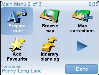
Touch the screen, select the second menu
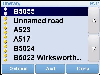
touch the "Itinerary Planning" icon, you will be presented with your itinerary.
You will notice that waypoints that are passed will be greyed out, those unvisited below will be solid (ignore the inverse video of any line, that's an artifact of the computer program operating the Tomtom).
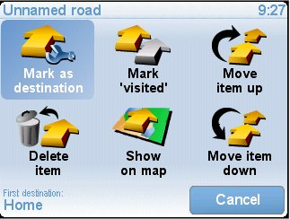
Touch the offending itinerary entry (probably the first non-greyed line, in my example the "Unnamed Road"). You will be offered the itinerary option menu
Touch the "Mark 'visited'" icon.
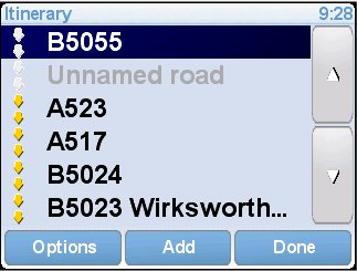
You will be back with the itinerary list with that line greyed out.
If this wasn't the first waypoint not visited, any previous one will also be marked as visited.
Touch the "Done" button, navigation will resume.
Should you decide to re-introduce a waypoint (maybe you got rid of the wrong one), repeat the procedure, the button that was "Mark 'visited'" will be now called "Mark 'to visited'", and will restore the waypoint to ungreyed (and any after it that were greyed).
Of course, you could always simply use the "Delete Item" button to remove a single entry.
Hope that helps.