YFO 2017 Yosemite Group Ride Planning Thread

Yamaha FJR Motorcycle Forum

Help Support Yamaha FJR Motorcycle Forum:

This site may earn a commission from merchant affiliate links, including eBay, Amazon, and others.
Tyler promised me, if I ride all the way out there, that all of the roads would be open...JSNS
whistling.gif


Last edited by a moderator:
As usual, touring early in the season garners lesser crowds and better rates in the U.S. and Canadian west . . . but it comes with a weather risk. There are ways to get across the Sierras and there are lots of great roads on both sides. Best of all, high snowpack will yield most impressive waterfalls in June - Yosemite will be especially spectacular. Everything will be beautifully lush.

But don't bet your travelin' money on what our local bug killer and/or Miss T are wishfully trying to sell you about the chances of getting from Hwy. 49 on the west to Hwy. 395 on the east across either Sonora (108) or Tioga (120) passes. :rolleyes: Cabin fever has set in out here, and those two could well be posting under the influence of some high powered Cali bud. It's legal out here now, ya know (shameless Cali Chamber of Commerce plug). ;)

As of today, snowpack is 180% of average for this date in the Central Sierra and 238% of average for the Southern Sierra. If you are actually going up to ski all this new snow (when the roads and resorts haven't been closed), it feels like '94/'95 in particular and maybe like '97/'98 also. Both years, I skied at Alpine July 4 in the morning and played golf in Tahoe City in the afternoon before watching the fireworks from the course. Pass openings were late those years; ski mountaineering was good. This is the same kind of snow year.

We won't so much be waiting for the snow to melt off the summits of 120 and 108. Once the weather warms sufficiently, road crews will be clearing it with rotary plows, loaders, etc. But the deeper and denser the snowpack, the longer that takes, and I seriously doubt that their budget will be increased for additional equipment and manpower to open those passes earlier when there are alternate routes available for the purpose of commerce. Not for a second should you think that issue might really detract from the riding experience of this rolling Cali clusterfeck. Indeed, when Wheaties and airboss came out in May 2011, they didn't get to ride those passes for the same reason, but no one would tell you that wasn't one of the best rolling get togethers ever.

Plan on, brother (and sister) FJR dudes! And neighbor Doug - don't bogart that spliff if you're still sitting on extra stash at storm's end. . :p

 
Last edited by a moderator:
OK - new subject:

Does anybody know if I can see Giant Cactus without having to go as far south as the desert near Tucson, AR? I don't have to spend a whole day for this - I'd just like to see a few of those plants - maybe pick a road that I could ride among them.

How hot will Death Valley NP be in late May (perhaps in route to YFO)?

 
Here ya go, Pants.

saguaro--park-01.jpg


Edit: OK, smartass reply. Only place I've seen them is southern AZ near Phoenix. Don't believe I've seen 'em in DV. Might not be too hot there in late May. And anyway, it's a, you know, dry heat.
wink.png


Last edited by a moderator:
OK - new subject:
Does anybody know if I can see Giant Cactus without having to go as far south as the desert near Tucson, AR? I don't have to spend a whole day for this - I'd just like to see a few of those plants - maybe pick a road that I could ride among them.

How hot will Death Valley NP be in late May (perhaps in route to YFO)?
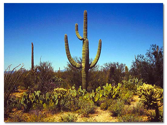
Funny you should mention Tucson. We're planning on dropping down to Casa Grande to see my uncle. Big cacti all over down there. And thinking about running DV at night, on the way to YFO.

 
I want to see these big Cactus. I can't explain it but I just do. Tucson is a bit out of my "shortest" route that I'm looking over. I'd rather run East-West north of Flagstaff, or at least north of Phoenix.

I'm also thinking DV on the way in to YFO. But like the Cactus, I want to actually see it (during the day). It's not a "I was technically there" kind of thing, whereby I just ride through it during the wee hours. Like the Cactus, I don't have to spend 48 hours drooling over it. I just want to ride through, perhaps stop a few times to sniff around, and then keep going. But if it's going to be 125 degrees, that may not be practical.

 
I want to see these big Cactus. I can't explain it but I just do. Tucson is a bit out of my "shortest" route that I'm looking over. I'd rather run East-West north of Flagstaff, or at least north of Phoenix.
I'm also thinking DV on the way in to YFO. But like the Cactus, I want to actually see it (during the day). It's not a "I was technically there" kind of thing, whereby I just ride through it during the wee hours. Like the Cactus, I don't have to spend 48 hours drooling over it. I just want to ride through, perhaps stop a few times to sniff around, and then keep going. But if it's going to be 125 degrees, that may not be practical.
Lived in Tucson most of my life and those giants are pretty cool. They are pretty much found within the bounds of the Sonoran Desert, though I can't really recall how far East they extend. If your slabbing it out I-10 you will pass through Tucson on your way to Phoenix, I would take 60/93 out of Phoenix on your way to DV, unless you wanna hit the Grand Canyon. It will be hot end of May, likely in the 100 degree range

 
Temp Data for DV
High LOW in Fahrenheit by month

67 40 January
73 46 February
82 55 March
91 62 April
101 73 May
110 81 June
117 88 July
115 86 August
107 76 September
93 62 October
77 48 November
65 38 December
91 63 Year


Better go early in the Morning

I have camped out North of Vegas in late July and it was cold up in the hills at night. The next morning going through DV was fine, but by the afternoon, it was 107 in Lone Pine on the way to Yosemite

 
Ok - this is helpful. The more I look at this, the more I like taking the "southern route" going West (first). Even waiting only 1 week, things are going to be heating up over there. If it's too hot, I can just hug the CO/NM/AZ/UT borders and stay in the upper elevations. I've already done that, and do want to see some new things.

I'm hoping to avoid the interstate for ALL of the trip. I agree - DV will have to be timed for a morning run.

Moving on:

1. Has anyone ridden the Gila National Forest in New Mexico? I like the look of the East-West highway 59 and 159.

2. Anybody seen the "Elephant Butte" and Rock Canyon north of Las Cruces? Worth seeing? Camping there? What the heck is "truth or consequences" in that area?

3. I seem to remember hearing good things about Hwy 191 in Arizona - it runs north/south - I could use it as a connector pulling a bit north and then jogging toward Phoenix, perhaps.

I hope this isn't received as thread jacking. I'm going to do a bit more planning for this trip than I normally do. So this information helps that.

 
Well Pants, if you enjoyed riding the Dragon you're going to love 191. Maybe stay on 191 all the way to I 40 to continue west.

Not that we like riding the interstate that much. It's just that sections of the mother road RT 66 parallel I 40 along with the associated memorabilia.

standing_on_the_corner__winslow__arizona_by_irational_xpressions-d8mx7z9.jpg


Last edited by a moderator:
Pants, follow Airboss' advice, do not miss Hwy 191 (the old 666). It is a great twisty road, but top off before starting out, it's a ways between fuel stations.

 
Last edited by a moderator:
Not sure about those listed DV low temps. When Carl, Tony, and Rich did their Heaven to Hell ride after nafo last year, the 1:30 am temp in Bad Water Cali was something like 114F iirc.
not_i.gif


Last edited by a moderator:
Pants, follow Airboss' advice, do not miss Hwy 191 (the old 666). It is a great twisty road, but top off before starting out, it's a ways between fuel stations.
+1 on the fuel.

Top off in Clifton, next sure fuel is Springerville. The store in Alpine has fuel, but sometimes not.

 
Pants, follow Airboss' advice, do not miss Hwy 191 (the old 666). It is a great twisty road, but top off before starting out, it's a ways between fuel stations.
+1 on the fuel.

Top off in Clifton, next sure fuel is Springerville. The store in Alpine has fuel, but sometimes not.
Good advice in general for some of you easterners. You really don't want to ride past gas stations at all in big hunks of the west. I've never really run dry, but I've come way too close a few times. (By the way, I carry a length of tubing from Home Depot long enough to siphon, just in case. The clear tubing. If you ever got a mouthful of gas cuz you didn't realize it was almost down to the end of the hose, you know why.)

 
Message understood re: distance between fuel stops. We did experience that in Utah. My bike's fuel mileage rose considerably as I got up in altitude, too. My effective range loaded was 300 miles.

Never been referred to as an "Easterner". I think I kind of like it....
smile.png


Edit - again, appreciate the info from my Western friends. I'm having fun studying the map. I kind of didn't want to go there this early out, it just makes it harder to quell the excitement. But I've opened the box now, there's no turning back....

 
Last edited by a moderator:
Message understood re: distance between fuel stops. We did experience that in Utah. My bike's fuel mileage rose considerably as I got up in altitude, too. My effective range loaded was 300 miles.
Yeah, but.

Between Clifton and Alpine, forget gas mileage. You will be on a constant up hill climb, lot of 2nd and 3rd gear work.

 
And you can't trust the GPS info on gas stations, doing so can lead to some serious pucker factor

 
And you can't trust the GPS info on gas stations, doing so can lead to some serious pucker factor
Boy, don't I know about that. Northern Cali had me coasting down hills this one time.
Hehehe . . . I recall doing the same thing into Idaho City, grimacing at any uphill hump or flat stretch, refusing to assist with power until I was below 20 mph. Awful glad to get to I.C. and find an open gas station. And yes, I can think of a number of places in northern Cali where you might have that problem by passing a single gasoline opportunity.

 
Last edited by a moderator:
Top