


Mount Rainier
Well-known member
The following is a wonderful description of our Oct. 18th SS1000 authored by Tim Bowman. It was such a pleasure riding with Tim and reading his followup report I wanted to share it here.
We planned the ride, and we rode the plan.
My friend, Jim Carroll, and I are participating in the SPANK Rally, and one of the bonuses in that Rally is to do a 1,000 mile ride within 24 hours inside of a state with the route not crossing at any point. We conferred about various route options and decided to do one together that would take us over the safest route across the Cascade Mountain Range. Since my preferred route would have taken us over the North Cascades Highway where it was projected to be at freezing temperatures, Jim proposed a route that would use two lower passes. His common sense approach prevailed and we settled on a route that we each loaded into our GPS’. Each of the major corners were to be documented by leaving a post card at the closest post office indicating the date, time, and location of the post office plus one at the start and finish.
After leaving our start postcard at the Tukwila post office and documenting the start with a time stamped receipt from a gas station (Jim) and an ATM receipt (me), we departed in the dark dry early morning of October 18, 2012 around 4:15am and made our way to the first stop in Monroe to deposit a postcard marking the first corner. Jim discovered that his SPOT wouldn’t turn on, so mine would be the one that his wife and others would follow, and serve as one of our pieces of ride documentation.
The ride over Stevens Pass was completely in the dark and as we approached Wenatchee the first rays of the new dawn poked their way over the horizon creating very pretty pink colors on the bare hills on our left side. As this is apple country, orchard workers were up and about readying for the days picking activity. A little farther north along US97 we passed by the fire zone from earlier in the year. The strong acrid smell was still in the air and the blackened remains of the sagebrush was all that remained of vegetation. The road seemed to act as sort of a fire line.
At Pateros we stopped at the Chevron station to refuel. Jim’s FJR 1300 only has a 200 mile range while my ST1100 can go 350 between fuel stops at legal speeds, but it was important that we do synchronized fuel stops to save time. We continued on through Brewster and Omak (home of the world famous Omak Stampede) to Tonasket where we marked our eastward turn by leaving our postcards with a less than friendly postal clerk. After a quick bio break at the local Mobil station, eastward we headed on one of the best sections of WA20. Outside of town, the first day’s critter count started with 3 deer crossing the road in front of us. Just a bit further Jim spotted a large herd of 20 or so on the hillside to our right. It turned out that those would be the last of the ‘forest rats’ that we’d see until I spotted one near Dayton hours later.
We passed through Republic and it brought back memories of a number of previous trips there including visits with friends who live north of town. But alas there would be no stop for a visit as we were ‘on the clock’. Since most of this ride was on secondary roads, the key to a successful 1,000 mile day was to keep the wheels moving. One only needs to ‘average’ 42 miles per hour over 24 hours to log 1,000 miles. I’ve done previous saddle sores in around 18 hours, but that takes riding a lot of freeway miles, and this was not the case on this ride.
Sherman Pass at 5,575 feet was soon crossed and it would be the highest point in the ride. It was also one of the prettiest and the tamarack trees displayed vibrant red and orange colors as they began their preparation for the long, cold winter.
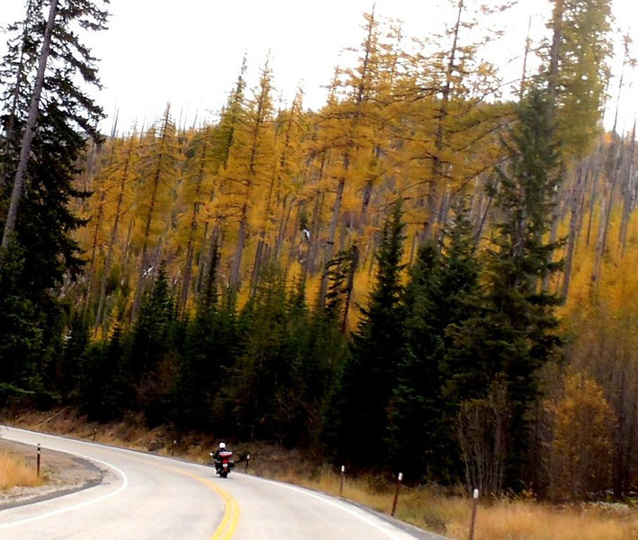
Jim Carroll Riding up Sherman Pass on WA20
Soon we dropped down through the twisty WA20 to cross the mighty Columbia River at Kettle Falls where we were stopped for a few minutes at the first of many road work zones we would encounter this day.
At Colville we deposited our third corner marking postcard with a friendly clerk. Yes, there was hope for this fine day of riding that our only human encounters would turn out to be pleasant. I also mailed a couple other postcards that gained me further rally points. The rest of the ride down US 395 was pleasant with a quick fuel stop at Chewelah and a boring stop and go ride through Spokane where we connected up with US195 which took us south through the now bare wheat and grain fields of the Palouse Country. North of Colfax we took a quick bio break at a vacant rest stop. But by the time we left, it was full.
Soon the towns of Steptoe, Colfax, Pullman, Colton, and Uniontown were specks in our rear view mirrors. At the top of the Lewiston Grade, the view of the Snake River was majestic as it snaked its way to the confluence with the Columbia many miles ahead to the west.
We descended the grade and through what was to be the only radar trap we noted in the entire trip. At the bottom of the grade, we quickly located the post office at Clarkston and left our cards with another friendly clerk. Another quick fuel stop at a Conoco satisfied Jim’s FJR’s fuel needs while once again my ST still had 150 more miles of range.
We were now westward bound and past the halfway point. The GPS calculation was showing a finish time of around 12:30 to 1:00am. Could we keep the pace up?
US12 snakes its way west through small farming towns along the southern border of Washington State. Pataha, Pomeroy, Dayton and the like were soon memories including the very nice Pataha Mill. Just outside Waitsburg came the surprise of the day!
While rounding a corner, on our left was a large and very live camel. As soon as I spotted it, I remembered from the Dam Tour ride earlier in the year where another rider commented ‘don’t miss the camel!’ It’s these sorts of sights that help re-sharpen one’s senses on a long ride.
Just west of Touchet, another milestone was reached. Jim’s FJR turned over 100,000 miles on the odometer, and we stopped briefly so he could properly document the occasion with some photos. It’s a nice milestone as I remembered doing the same on my Gold Wing earlier in the year.

Further west we approached the Tri-Cities and once again crossed the Snake and Columbia Rivers. Only this would be the last time this trip, and it would be in the fading twilight. Another fuel stop was made on the outskirts of Kennewick which would take us to north of Yakima.
As we headed down WA14 on the north bank of the Columbia River in the pitch black early evening, Jim tucked us in behind a semi-truck carrying a load of cars. It was good to let the truck blaze the way through the darkness and the driver set a reasonable pace. On a hill just before we turned north on US97, we passed the truck and waved our appreciation to the driver for being our shield for 70 some miles. Sometimes one doesn’t need to lead; and this was one of those times. It was along this road that we enjoyed a very pretty night view of the John Day Dam. In the darkness, the dam lighting really “popped!”
The now closed for the day Goldendale Post Office received our documentary post cards and a quick bio break at the service station next door took care of our personal needs. A fellow at the service station commented on how cold it was and I just held up my Gerbings Electric Clothing power cord, and he signaled his understanding. It is nice to be able to ride and keep comfortably warm. I also checked the weather on my smart phone and noted it was raining on Snoqualmie Pass, so we made plans for a pull off at the pass so I could don some raingear.
We passed through several more construction zones and one was the longest wait of the day at around 10 minutes. The darkness was only broken by the artificial temporary lighting that cast surreal shadows on a very lonely stretch of road.
Just east of Selah we took our last refueling stop of the trip. I toyed with the idea of not refueling but discarded that idea since we’d be riding in dark, wet, and isolated country. It’s better to be safe than sorry. In the end, I would have been safe but that’s 20/20 hindsight.
Sure enough, just west of Ellensburg it started to first sprinkle. By the time we stopped at the Indian John Rest Area so I could don my Frogg Togg rain jacket, it was apparent that this last section of the ride would be a bit damp. That was added to the darkness, stirred and shaken, and the result was a wet and dark riding concoction.
Standing water was everywhere and with all of the recent construction, it was a challenge to navigate the numerous temporary lane changes. But we made it through, and our descent was made without incident. I later learned from Jim that my low beam was adjusted too high and made it particularly challenging for him to ride in the adverse weather conditions. Here’s where bike to bike communications could have been valuable, and it’s a common ingredient on my Gold Wing group rides. On the ST1100, it’s an easy adjustment for me to make using a dashboard headlight adjustment knob. I definitely felt bad about not knowing this information during the ride.
The wet ride continued west on I-90 to WA18 where we headed south to Federal Way and the last corner point on the ride. Our postcards were quickly deposited in the dropbox at around 12:30 am, and then we began the last leg north the short distance on I-5 to our finish at Tukwila.
The Chevron station was a welcome sight, and our receipts stamped at 1:04am ended the ride. My first receipt didn’t clearly indicate the date, but fortunately there was an on-duty clerk who provided me with a duplicate receipt which showed the correct date and time. We prepared and deposited the documentary finish post cards in the post office drive through mailbox to put the bow on the package. It had been a good and safe ride. We shared a 1030 mile view of our entire state in less than 24 hours. Would there be more?
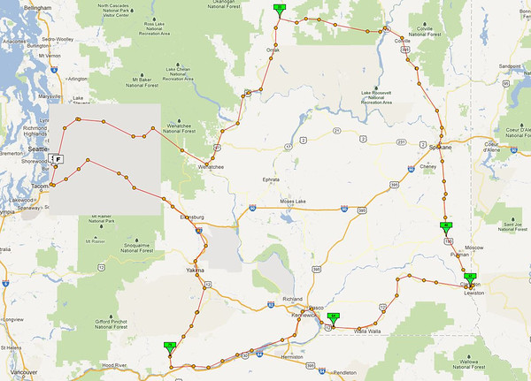
For the curious, below is a picture of the SPOT tracking map. It’s a very interesting route that showcases much of Washington State.
Thanks much Tim.
Keep Going!
We planned the ride, and we rode the plan.
My friend, Jim Carroll, and I are participating in the SPANK Rally, and one of the bonuses in that Rally is to do a 1,000 mile ride within 24 hours inside of a state with the route not crossing at any point. We conferred about various route options and decided to do one together that would take us over the safest route across the Cascade Mountain Range. Since my preferred route would have taken us over the North Cascades Highway where it was projected to be at freezing temperatures, Jim proposed a route that would use two lower passes. His common sense approach prevailed and we settled on a route that we each loaded into our GPS’. Each of the major corners were to be documented by leaving a post card at the closest post office indicating the date, time, and location of the post office plus one at the start and finish.
After leaving our start postcard at the Tukwila post office and documenting the start with a time stamped receipt from a gas station (Jim) and an ATM receipt (me), we departed in the dark dry early morning of October 18, 2012 around 4:15am and made our way to the first stop in Monroe to deposit a postcard marking the first corner. Jim discovered that his SPOT wouldn’t turn on, so mine would be the one that his wife and others would follow, and serve as one of our pieces of ride documentation.
The ride over Stevens Pass was completely in the dark and as we approached Wenatchee the first rays of the new dawn poked their way over the horizon creating very pretty pink colors on the bare hills on our left side. As this is apple country, orchard workers were up and about readying for the days picking activity. A little farther north along US97 we passed by the fire zone from earlier in the year. The strong acrid smell was still in the air and the blackened remains of the sagebrush was all that remained of vegetation. The road seemed to act as sort of a fire line.
At Pateros we stopped at the Chevron station to refuel. Jim’s FJR 1300 only has a 200 mile range while my ST1100 can go 350 between fuel stops at legal speeds, but it was important that we do synchronized fuel stops to save time. We continued on through Brewster and Omak (home of the world famous Omak Stampede) to Tonasket where we marked our eastward turn by leaving our postcards with a less than friendly postal clerk. After a quick bio break at the local Mobil station, eastward we headed on one of the best sections of WA20. Outside of town, the first day’s critter count started with 3 deer crossing the road in front of us. Just a bit further Jim spotted a large herd of 20 or so on the hillside to our right. It turned out that those would be the last of the ‘forest rats’ that we’d see until I spotted one near Dayton hours later.
We passed through Republic and it brought back memories of a number of previous trips there including visits with friends who live north of town. But alas there would be no stop for a visit as we were ‘on the clock’. Since most of this ride was on secondary roads, the key to a successful 1,000 mile day was to keep the wheels moving. One only needs to ‘average’ 42 miles per hour over 24 hours to log 1,000 miles. I’ve done previous saddle sores in around 18 hours, but that takes riding a lot of freeway miles, and this was not the case on this ride.
Sherman Pass at 5,575 feet was soon crossed and it would be the highest point in the ride. It was also one of the prettiest and the tamarack trees displayed vibrant red and orange colors as they began their preparation for the long, cold winter.
Jim Carroll Riding up Sherman Pass on WA20
Soon we dropped down through the twisty WA20 to cross the mighty Columbia River at Kettle Falls where we were stopped for a few minutes at the first of many road work zones we would encounter this day.
At Colville we deposited our third corner marking postcard with a friendly clerk. Yes, there was hope for this fine day of riding that our only human encounters would turn out to be pleasant. I also mailed a couple other postcards that gained me further rally points. The rest of the ride down US 395 was pleasant with a quick fuel stop at Chewelah and a boring stop and go ride through Spokane where we connected up with US195 which took us south through the now bare wheat and grain fields of the Palouse Country. North of Colfax we took a quick bio break at a vacant rest stop. But by the time we left, it was full.
Soon the towns of Steptoe, Colfax, Pullman, Colton, and Uniontown were specks in our rear view mirrors. At the top of the Lewiston Grade, the view of the Snake River was majestic as it snaked its way to the confluence with the Columbia many miles ahead to the west.
We descended the grade and through what was to be the only radar trap we noted in the entire trip. At the bottom of the grade, we quickly located the post office at Clarkston and left our cards with another friendly clerk. Another quick fuel stop at a Conoco satisfied Jim’s FJR’s fuel needs while once again my ST still had 150 more miles of range.
We were now westward bound and past the halfway point. The GPS calculation was showing a finish time of around 12:30 to 1:00am. Could we keep the pace up?
US12 snakes its way west through small farming towns along the southern border of Washington State. Pataha, Pomeroy, Dayton and the like were soon memories including the very nice Pataha Mill. Just outside Waitsburg came the surprise of the day!
While rounding a corner, on our left was a large and very live camel. As soon as I spotted it, I remembered from the Dam Tour ride earlier in the year where another rider commented ‘don’t miss the camel!’ It’s these sorts of sights that help re-sharpen one’s senses on a long ride.
Just west of Touchet, another milestone was reached. Jim’s FJR turned over 100,000 miles on the odometer, and we stopped briefly so he could properly document the occasion with some photos. It’s a nice milestone as I remembered doing the same on my Gold Wing earlier in the year.
Further west we approached the Tri-Cities and once again crossed the Snake and Columbia Rivers. Only this would be the last time this trip, and it would be in the fading twilight. Another fuel stop was made on the outskirts of Kennewick which would take us to north of Yakima.
As we headed down WA14 on the north bank of the Columbia River in the pitch black early evening, Jim tucked us in behind a semi-truck carrying a load of cars. It was good to let the truck blaze the way through the darkness and the driver set a reasonable pace. On a hill just before we turned north on US97, we passed the truck and waved our appreciation to the driver for being our shield for 70 some miles. Sometimes one doesn’t need to lead; and this was one of those times. It was along this road that we enjoyed a very pretty night view of the John Day Dam. In the darkness, the dam lighting really “popped!”
The now closed for the day Goldendale Post Office received our documentary post cards and a quick bio break at the service station next door took care of our personal needs. A fellow at the service station commented on how cold it was and I just held up my Gerbings Electric Clothing power cord, and he signaled his understanding. It is nice to be able to ride and keep comfortably warm. I also checked the weather on my smart phone and noted it was raining on Snoqualmie Pass, so we made plans for a pull off at the pass so I could don some raingear.
We passed through several more construction zones and one was the longest wait of the day at around 10 minutes. The darkness was only broken by the artificial temporary lighting that cast surreal shadows on a very lonely stretch of road.
Just east of Selah we took our last refueling stop of the trip. I toyed with the idea of not refueling but discarded that idea since we’d be riding in dark, wet, and isolated country. It’s better to be safe than sorry. In the end, I would have been safe but that’s 20/20 hindsight.
Sure enough, just west of Ellensburg it started to first sprinkle. By the time we stopped at the Indian John Rest Area so I could don my Frogg Togg rain jacket, it was apparent that this last section of the ride would be a bit damp. That was added to the darkness, stirred and shaken, and the result was a wet and dark riding concoction.
Standing water was everywhere and with all of the recent construction, it was a challenge to navigate the numerous temporary lane changes. But we made it through, and our descent was made without incident. I later learned from Jim that my low beam was adjusted too high and made it particularly challenging for him to ride in the adverse weather conditions. Here’s where bike to bike communications could have been valuable, and it’s a common ingredient on my Gold Wing group rides. On the ST1100, it’s an easy adjustment for me to make using a dashboard headlight adjustment knob. I definitely felt bad about not knowing this information during the ride.
The wet ride continued west on I-90 to WA18 where we headed south to Federal Way and the last corner point on the ride. Our postcards were quickly deposited in the dropbox at around 12:30 am, and then we began the last leg north the short distance on I-5 to our finish at Tukwila.
The Chevron station was a welcome sight, and our receipts stamped at 1:04am ended the ride. My first receipt didn’t clearly indicate the date, but fortunately there was an on-duty clerk who provided me with a duplicate receipt which showed the correct date and time. We prepared and deposited the documentary finish post cards in the post office drive through mailbox to put the bow on the package. It had been a good and safe ride. We shared a 1030 mile view of our entire state in less than 24 hours. Would there be more?
For the curious, below is a picture of the SPOT tracking map. It’s a very interesting route that showcases much of Washington State.
Thanks much Tim.
Keep Going!
Last edited by a moderator:
