Cell phone GPS question

Yamaha FJR Motorcycle Forum

Help Support Yamaha FJR Motorcycle Forum:

This site may earn a commission from merchant affiliate links, including eBay, Amazon, and others.

Steel_Gin

Well-known member
Joined
Oct 15, 2011
Messages
568
Reaction score
127
Location
New York, Finger Lakes Region
Since my phone has GPS built-in I had the thought, why would I need a separate GPS unit?? The phone is far from being water proof so I'm thinking I could keep in the storage compartment in the fairing. So, here is my question and I know this will vary from phone to phone: I have a Motorola Razr Maxx, has anyone used the GPS, left it in the fairing paired with their Bluetooth headset and still receive the turn by turn directions?

I'm thinking about getting a Sena SMH10 with the primary thought of hearing directions, but if the phone can't pull in the GPS signals in the storage compartment I need to re-evaluate. I know I could keep my phone in my jacket but I like keeping it plugged in when ever possible.
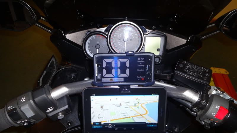
 
This isn't an FJR specific thread. Move it for 'ya.
wink.png


Many phones will provide basic GPS receiving services, but it will also provide a basic camera, basic surfing of the internet, maybe open an Excel file in an e-mail attachment, etc. Would you use your phone to work on Excel file instead of a full-fledged computer at work? If you were an amateur photographer would you use your phone to capture a sunset? Would you actually use a swiss army knife to saw down a tree and cut your steak at a restaurant?

Same thing for many people that want to utilize a GPS receiver for a variety of functions. Will your phone provide routing services with multiple points along the way? Will it and the application accomplish it if you're not connected to a cell network? Can you change that route while riding conveniently? If you want to find a gas station along the route can you insert it in while riding easily?

A dedicated GPS receiver (like Garmins) will do these things and many more far better than any smartphone. Plus most models are water rain proof .....it's a lot better IMO. In fact, in my case I have a Street Pilot 2820 that's not talking bluetooth to my Sena and I thought I'd reexamine Garmin options since that model is years old and only available used.....I'm unimpressed with replacements for it as Garmin products have increasingly dumbed themselves down and includes extraneous features. To me a dedicated GPS receiver is basic equipment on most any ride that I put earplugs in for.

Now, if there was a better app for an iPhone (or other smartphone) were available than the current Garmin OS...I'd consider changing. Until or unless that happen, I look at who places well in motorcycle rallies and what they're using is what I'm probably using. To date nobody I know in the ranks of top dogs have used a cell phone GPS receive to place well in a rally. They use their cell phones to call ahead for hotel reservations and loved ones how they're doing and have one or more Garmins on their dash (except for Ken Meese who has Lowrance).

 
Last edited by a moderator:
I have a Sena SMH10 and a Droid Razr. The GPS functionality works perfect. BT has plenty of range. Consider the app "Sygic" for GPS. Uses satellite only and doesn't require a data connection to function. Also consider a "Ram Bone" for a great way to mount your phone to the bike. You can also get an Aqua box that fits the Rambone to keep your Droid dry. And I will add the Sygic app on my droid does everything my Garmin could do (alternate routes on the fly, POS for gas food etc) also get free updates.

 
Last edited by a moderator:
Yep works fine, for remote areas you will want to predownload the area in your google(maps) powered GPS app. New feature, they let you capture the map area so it can now work offline (no cell reception needed)...

There are two ways to select an area:

  1. Go to Menu > Make available offline. The area selector will appear on your screen
    .
  2. Go to Maps > My Places > Offline > New offline map. A dialog will appear on your screen where you can type a region or city--like New York--to select from the map.
To choose and download an area, pinch and zoom on the map within the area selector and then save your selection.

  • Estimated size: To find the estimated size of an area you’ve selected, look at the bottom of your screen.
  • Maximum download size: You can download up 6 maps total as long as you have sufficient storage space on your device. There’s also a maximum size for the area you can download; if surpassed, you’ll be asked to zoom in to a smaller area.
  • Storage capacity: When your device’s storage is at capacity and can’t save the entire area, your phone will pause the download and show the message "Download failed. Storage may be full." You can resume the download after you’ve cleared some space on your device.
Note: You may also see black outlines delineating areas where you’ve already saved an offline map.


Now you can do like me who graduated from the Droid Razr (as GPS) to a bigger more useful screen, here's my current setup with the Droid acting as a Radar detector (and phone of course!)...

Picture20549_zps6579ef45.jpg


If interested in my supersized GPS setup? thread here

Cheers

 
My question would be does it work if you have no cell signal? If so, it would not be an option for me as I frequently ride in remote, no cell coverage areas. I have a Garmin Zumo 665 that pairs with my Scala Rider Teamset helmet communication and also with the cell phone. When I do have cell coverasge I can answer and dial through the Zumo. The Zumo has every feature you want in a GPS and it was designed for motorcycle use. All that being said, I do know some who use the phone in an Otterbox for weatherproofing.

 
My question would be does it work if you have no cell signal? If so, it would not be an option for me as I frequently ride in remote, no cell coverage areas. I have a Garmin Zumo 665 that pairs with my Scala Rider Teamset helmet communication and also with the cell phone. When I do have cell coverasge I can answer and dial through the Zumo. The Zumo has every feature you want in a GPS and it was designed for motorcycle use. All that being said, I do know some who use the phone in an Otterbox for weatherproofing.
This is why all the talk of offline maps, so your answer is yes (if you use a GPS app with offline preloading capabilities).

The Zumo's are very nice but your stuck with it. Using our 'open source' GPS map-apping (new word lol!) we can flop/flock to other GPS apps (several with big advantages over the Garmin GPS-only units). Plus the graphics are much better, Garmins maps are still stuck in the year 2000. And I'm not even mentioning stuff like real Satellite imagery for our background maps, mega configurations, ease of upgrade software, maps and apps wireless, way easier than any Garmin ever thought of, oh and this is all done FREE!. Don't get me wrong, the Zumo does have a couple of advantages but the way the ball is rolling around them, it's crumbling fast. The 'Open source' theme that Android uses... rocks! and with millions of programmers/testers/evaluators it's just overwhelming the way that it's coming on.

 
Google Maps downloaded offline maps are not routeable. You'll see where you are, and if you stick to the route you built while you had cell data, you'll be OK. You can't reroute or recalculate until you get to a data area.

And there is a limit to how much of their map you can download like that.

 
Ram Mounts makes Ram Aqua Boxes in six sizes which one will surely fit your cell/Razr, totally weather-proof. I use both GPS aps on IPhone and Garmin GPS to navigate when lost which is most of the time. They both have their pluses and minuses. I like the Aqua box because I am cheap and don't want to spend the money on the MC dedicated Zumo. I've got 40,000 miles on a referb Garmin and haven't managed to break it yet. Ram Aqua boxes keep your touch screen capabilities. Ride safe.

 
I end up using my iPhone and the TomTom app for a very specific reason - I have the Cardo headsets added into my helmets and it can only pair with a very limited number of GPS units but it does pair with the iPhone just fine. I have a RAMBONE added to my bike and have the iPhone mounted on that and then I used the power point in the glove compartment on my bike to power the iPhone. I get to send/receive calls hands-off, can listen to Pandora or iHeart radio and also get turn by turn using the TomTom app. Worked pretty darn well for my. Biggest issue I have with this or ANY GPS really is that you cannot use the touch screens with MC gloves on. Have to pull the gloves off at a stop light to do anything then quickly get them back on to take off from the light. Minor I know but still a PITA.

 
Thanks for the suggestions everyone!! :) Since I'll only do only one trip a year at best buying a GPS right now doesn't make sense for me. I will look at the programs suggested, liking the idea of no data use and pre-loading the map. For my trip I will be on a tight schedule which means no venturing off unfortunately and getting lost. Liking the RAM Aqua box idea, might open the wallet for that if it isn't too expensive. Then again I have already bought a Russell Day Long, Helibar triple tree and a Y.E.S. over the past couple months, another $50 isn't going to make the wallet scream any louder than it already is.

Top_Speed1, very cool looking setup!! If it works out I'd like to meet up and check it out some time since you are not far down the road.

 
Biggest issue I have with this or ANY GPS really is that you cannot use the touch screens with MC gloves on. Have to pull the gloves off at a stop light to do anything then quickly get them back on to take off from the light. Minor I know but still a PITA.
Lots of folks are making gloves that will work with touch screens .

https://www.aerostich.com/clothing/gloves

 
Stylus doesn't work with touch-screen phones, either. They use capacitance, and have to "feel" your skin (or conductive material in a glove.)

"Real" GPS units line Streetpilots and Zumos work fine with gloves. They are pressure-sensitive touch screens.

 
Yep works fine, for remote areas you will want to predownload the area in your google(maps) powered GPS app. New feature, they let you capture the map area so it can now work offline (no cell reception needed)...
There are two ways to select an area:

  1. Go to Menu > Make available offline. The area selector will appear on your screen.
  2. Go to Maps > My Places > Offline > New offline map. A dialog will appear on your screen where you can type a region or city--like New York--to select from the map.
To choose and download an area, pinch and zoom on the map within the area selector and then save your selection.

  • Estimated size: To find the estimated size of an area you’ve selected, look at the bottom of your screen.
  • Maximum download size: You can download up 6 maps total as long as you have sufficient storage space on your device. There’s also a maximum size for the area you can download; if surpassed, you’ll be asked to zoom in to a smaller area.
  • Storage capacity: When your device’s storage is at capacity and can’t save the entire area, your phone will pause the download and show the message "Download failed. Storage may be full." You can resume the download after you’ve cleared some space on your device.
Note: You may also see black outlines delineating areas where you’ve already saved an offline map.


Now you can do like me who graduated from the Droid Razr (as GPS) to a bigger more useful screen, here's my current setup with the Droid acting as a Radar detector (and phone of course!)...

Picture20549_zps6579ef45.jpg


If interested in my supersized GPS setup? thread here

Cheers
How has the radar det worked for you?

Can I get a link to info on this Android as radar detector please?

Thanks

 
Last edited by a moderator:
Biggest issue I have with this or ANY GPS really is that you cannot use the touch screens with MC gloves on. Have to pull the gloves off at a stop light to do anything then quickly get them back on to take off from the light. Minor I know but still a PITA.
Lots of folks are making gloves that will work with touch screens .

https://www.aerostich.com/clothing/gloves
I will have to look at that. The normal non-MC gloves I keep in my pocket for cold days does have the index finger and thumbs with capacitive panels so they work on the iPhone and my touch screen Navi in my car. I can wear them to keep my digits warm and still run the controls. Too lite and not protective to use for my MC but maybe I can retrofit.... Thanks for the suggestion!

 
Stylus doesn't work with touch-screen phones, either. They use capacitance, and have to "feel" your skin (or conductive material in a glove.)
"Real" GPS units line Streetpilots and Zumos work fine with gloves. They are pressure-sensitive touch screens.
I beg to differ sir. I have a few of these (rubber tipped) and they work just fine with capacitive screens.

You didn't click my link did ya? ;)

 
Biggest issue I have with this or ANY GPS really is that you cannot use the touch screens with MC gloves on. Have to pull the gloves off at a stop light to do anything then quickly get them back on to take off from the light. Minor I know but still a PITA.
Have you considered a stylus?

https://www.ebay.com/sch/?_nkw=rubber%20tip%20stylus&clk_rvr_id=467352742566
Seriously? LOL a stylus on a motorcycle? BWHAHAHAHA

I use the Streetpilot 2820 and Zumo 550 with gloves. This is a drawback to cell phones that need the inductive threads in the finger tips. Sorry, the phone as a GPS is a nonstarter since my iphone was killed by the sun and heat on a cross country trip. I'm sure they will eventually be hardened to the point that motorcycle use is possible.

For those of you that use your phones like this, be sure you have the extended warranty. You'll need it sooner than later. I actually tried to rescue my phone by putting it into ice cream freezers in South Dakota as it seized from the 107 degree ambient heat.

 
Last edited by a moderator:
Stylus doesn't work with touch-screen phones, either. They use capacitance, and have to "feel" your skin (or conductive material in a glove.)

"Real" GPS units line Streetpilots and Zumos work fine with gloves. They are pressure-sensitive touch screens.
I beg to differ sir. I have a few of these (rubber tipped) and they work just fine with capacitive screens.You didn't click my link did ya? ;)
I did, and Walt is correct. Those stylus pens work great with IPhones, but are useless for Droid phones. Most Droid phones work off of heat. Have you Droid users ever noticed you can sometimes click something without touching the screen? AND then, you're gonna manipulate that little stylus to use your phone call while underway with a gloved hand? Where you gonna store it?
Iggy hit the nail on the head. Using a phone for GPS has some functionality, but if you're trying to use it as your primary tool, you're setting yourself up for failure. Will it work in a pinch? Yup. Will it work in the middle of nowhere when you have to change routes because a semi just rolled and the road is closed? I'm betting not.

This whole "download your route before you leave" idea is great if nothing changes. BUT if nothing has ever changed during o e of your road trips, you either don't go very far, or don't ride very many miles.

I prefer the right tool for the job.

Edit: Tom is also right. Using a phone in this manner will quickly destroy it.

 
Last edited by a moderator:
Top