Seattle to SW-FOG Salida Co

Yamaha FJR Motorcycle Forum

Help Support Yamaha FJR Motorcycle Forum:

This site may earn a commission from merchant affiliate links, including eBay, Amazon, and others.

Fontanaman

Robin Trower
Joined
Oct 29, 2009
Messages
2,005
Reaction score
1,060
Location
Spokane, Wa
Trip from Seattle to Salida Colorado to attend SW-FOG
Day 1 and 2

My son graduated from the University of Washington with a BS in Economics on Saturday June 15th. We had a great time watching 4,500+ walk up and get their diplomas. Better yet was the family dinner afterward. The reason for mentioning this is, I am very proud of my son and I did not get to bed until 11:00pm on Saturday. To make matters worse I did not sleep well and got up at 5:30 with an ambitious first day ride plan - which I foolishly refused to change.

The plan was to enjoy minimize freeway travel on day one, travelling 600 miles then on day two ride from Ontario Oregon to Vernal Utah, nearly a 600 mile day. I was certain the first day would be splendid while the second day a slog down the freeway.

I could not have been more wrong.

Here is the route for day one. The route includes some of my favorite road in NE Oregon.

The bike was ready with a fresh rear tire, engine and final drive oil changed and a good wash jog. So I go out to start the bike, the engine turns but no ignition. I finally open the throttle while pressing the starter and it fires and runs fine. I shut it off and it fires right back up. This is a bad omen.

So I am off to Enumclaw where I take this photo of Mt. Rainier.

IMG_0758%2520%2528600x450%2529.jpg


It was in the low 50’s when I rolled through Greenwater, Washington on my way to Chinook Pass.

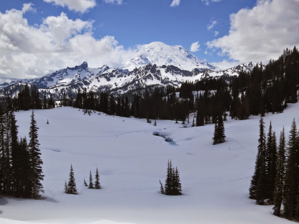
Near Chinook Pass I take this photo.

IMG_0759%2520%2528600x450%2529.jpg


The prior weekend it looked like this:

IMG_0745%2520%2528600x450%2529.jpg


At Chinook Pass, June 15, I take this photo of Mt. Rainier and Tipsoo Lake.

IMG_0760%2520%2528600x450%2529.jpg


On June 1st I took this photo at the same spot.

IMG_0732%2520%2528600x450%2529.jpg


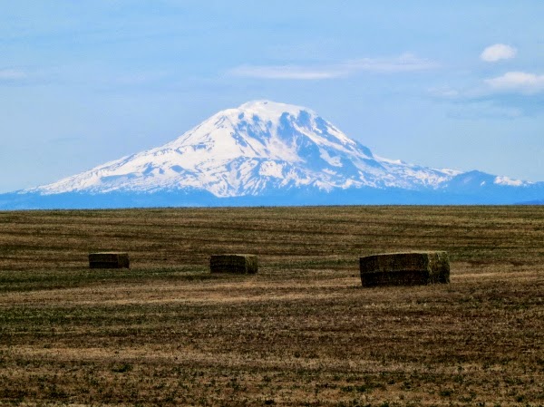
Continuing down Hwy 410 I got through Yakima and south on Hwy 97 where I found a couple of volcano’s to photograph.

Mt. Hood aka Snaggle Tooth

IMG_0763%2520%2528600x450%2529%2520%25282%2529.jpg


Mt. Adams aka an under appreciated mountain

IMG_0767%2520%2528600x449%2529.jpg


Once reaching Oregon I head west on I-84 for 18 mile to the Dalles then take Hwy 197 south. This detour add 35 minutes to my ride but I enjoy the roads.

To my right Mt. Hood is my companion.

IMG_0780%2520%2528600x450%2529.jpg


One of the reason to take this detour is to stop a White River Falls State Park.

IMG_0782%2520%2528600x450%2529.jpg


And the other is to enjoy Hwy 216 a nice twisty road.

IMG_0787%2520%2528600x331%2529.jpg


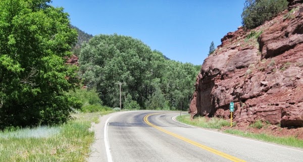
Then it is one to Hwy 218 on of Oregon’s finest.

Hwy 218 near Antelope Oregon

IMG_0788%2520%2528600x351%2529.jpg


After this I got tired and it was clear on this day I extended myself too far. I continued on and finally made it to Ontario Oregon twelve hours after starting out, plus I crossed into Mountain time.

Day two is from Ontario Oregon to Vernal Utah via the slab. I was off by 8:00am with 68 degree temps with blue skies. The freeway pavement was surprising smooth, winds light and traffic no problem. The speed limit in Idaho is 75 on the freeway so I make good time. I really enjoyed the slab, easy no brainer, no loose gravel to think about or much of anything. Finally the mind was free and I was enjoying this trip.

Once reaching Odgen I went along I-84 to Morgan Utah. Along the road I notice many dead deer - good once less deer that can take me out.

I drove by Park City and Dear Valley looking at the ski hills I skied in the 1980’s.

At Strawberry Reservoir I shot this photo.

IMG_0792%2520%2528600x450%2529.jpg


Nearing the end of day two, I had road from the Columbia River Basin, though the Salt Lake area which is a basin - water does not leave there, to the Colorado River Basin.

 
Last edited by a moderator:
Thanks Sam. I decided to leave my DSLR at home, saving the space of two lenses, the body plus the filters and tripod. On this trip I will try using my Canon Powershot S100 a camera; a true pocket camera.

 
Thanks for taking us along on the ride Jim.

Had to cancel Canada due to unforeseen circumstances so ride reports will have to suffice for the time being!

Love 218 and this area of Oregon!

IMG_0788%2520%2528600x351%2529.jpg


--G

 
Great pictures and RR Jim, looking forward to the rest of your trip report.

 
Last edited by a moderator:
Once again you have done all the work and provided us with another great route. Pictures are always a treat and the discriptions make for a great pre-runner. I will be checking this one out real soon. Well done and much thanks. Kudos and congrats to your son.

 
Once again you have done all the work and provided us with another great route. Pictures are always a treat and the discriptions make for a great pre-runner. I will be checking this one out real soon. Well done and much thanks. Kudos and congrats to your son.
Thank you. I learned about NE Oregon by attending the Oregon State BMW club annual meeting for a few years. Great event and they hold it in John Day on Father's Day weekend.

To see more about NE Oregon visit my blog.

Now excuse me I have to go visit Dinosaur National Monument.
smile.png


Day 3

So after two long riding days I am a stones throw from Colorado. Now it is time to slow down and get into vacation mode. The day dawned with promise and a quick shower. Standing in the small bathroom I notice the toilet seat was open. I closed it because of the high probability I would knock something I needed into the toilet. Sure enough I did but it shaving cream bounce harmlessly off the seat and onto the floor. A good oman!

Out of the hotel at 7:30 and the McDonald’s breakfast stop by 8:15 I headed to Dinosaur National Monument because I was here and I like geology. My route ended up in Grand Junction a short 250 mile ride filled fun.

Day 3 route.

My first stop was the Quarry Exhibit Hall where 700 tons of bones were excavated and sent to the Carnegie Museum in Pittsburgh.

On the way to the quarry.
IMG_0800%2520%2528600x450%2529.jpg


View at the quarry.
IMG_0801%2520%2528600x449%2529.jpg


The quarry is build into the side of a hill as shown in the follow photos. It sits on the site of the original quary sight from the 1900's.
IMG_0816%2520%2528600x450%2529.jpg


In the exhibit the quarry wall faces the visitors.
IMG_0803%2520%2528600x450%2529.jpg


IMG_0806%2520%2528600x450%2529.jpg


IMG_0808%2520%2528600x450%2529.jpg

A femur from a Camarasaurus - yes it is the name of a dinosaurs.
IMG_0809%2520%2528450x600%2529.jpg


The first structure built in 1958 was constructed on soft soil and had to be closed in 2006.
IMG_0811%2520%2528600x450%2529.jpg


An Allosaurus.
IMG_0814%2520%2528600x450%2529.jpg


IMG_0813%2520%2528600x450%2529.jpg


It is very rare to find an entire skull.
IMG_0815%2520%2528600x450%2529.jpg


The Green River from the Quarry Exhibit Hall.
IMG_0818%2520%2528600x450%2529.jpg


Hwy 149 just south of the Dinosaur National Monument
IMG_0819%2520%2528600x450%2529.jpg


IMG_0821%2520%2528600x450%2529.jpg


IMG_0822%2520%2528600x450%2529.jpg


Next I go to Harper’s Corner Road to see the Green and Yampa River Canyons.

Do you like the wide angle view.
IMG_0823%2520%2528600x450%2529.jpg


or the close up view.
IMG_0825%2520%2528600x450%2529.jpg


The Echo Park road is a 13 mile each way down and back. It goes the confluence of the Green and Yampa rivers. You can also see Steamboat Rock.

IMG_0827%2520%2528600x450%2529.jpg


Echo Park Road - Calling Auburn FJR do ride this on his FJR.
IMG_0826%2520%2528600x303%2529.jpg


Steamboat Rock
IMG_0831%2520%2528600x450%2529.jpg


IMG_0832%2520%2528600x450%2529.jpg


Harper’s Overlook
IMG_0828%2520%2528600x450%2529.jpg


Island Park Overlook
IMG_0829%2520%2528600x450%2529.jpg


My FJR
IMG_0830%2520%2528600x449%2529.jpg


Another Canyon Overlook
IMG_0834%2520%2528600x450%2529.jpg


I started to look closer to find photography subjects.
IMG_0836%2520%2528600x414%2529.jpg


IMG_0839%2520%2528600x297%2529.jpg


IMG_0844%2520%2528600x449%2529.jpg


Harper’s Corner Road was twisty is a few spots, but it was a chip sealed surface with some loose stone and quite a few straight sections. It was a smooth surface though.
IMG_0847%2520%2528600x450%2529.jpg


And it was scenic.
IMG_0849%2520%2528600x509%2529.jpg


IMG_0852%2520%2528600x395%2529.jpg


Exploring Monument took about 3 or 4 hours. My only regret was not going for a day long river raft excursion.

About six month ago I bought Steve Fawson’s book titled The Complete Guide to Motorcycling Colorado: The Definitive Reference for ALL the Best Roads, Rides, and Tips. He rides a BMW 1200 GS and it cover dirt road too but does cover all the paved road I was interested in. In this book I found Hwy 139 leading me to Grand Junction where I will spend the night.

From Rangely Co Hwy 139 lead south and from the beginning it is rough or as Fawson says choppy. Doing the speed limit is not enjoyable. It is scenic and interesting especially as you approach 8200 Douglas Pass.

Looking south of Douglas Pass
IMG_0854%2520%2528600x300%2529.jpg


IMG_0857%2520%2528600x450%2529.jpg


The road has no lines is narrow, steep and interesting.
IMG_0860%2520%2528600x436%2529.jpg


IMG_0861%2520%2528600x450%2529.jpg


It is scenic though....
IMG_0863%2520%2528600x449%2529.jpg


About 20 mile before I-70 Hwy 139 smooths out. I start seeing other things to photograph.
IMG_0870%2520%2528600x548%2529.jpg


Different perspective of the flower.....
IMG_0874%2520%2528600x450%2529.jpg


IMG_0876%2520%2528600x357%2529.jpg


Last edited by a moderator:
*Love* the photographs of your rides. I will be following in your tire tracks to see it all for myself.

 
Keep going my friend. This year's "One Big Motorcycle Trip" will be to Southern Colorado and Northern New Mexico. I am following this with greedy interest.

 
Day 4

/rant
Bad internet connection at the Western Hotel in Gunnison Co. prevented me from posting last night. I was at the end unit and the signal strength was low. Grrrrr
/end rant

I decided to make this a riding day and see what I could see. After eating a quick breakfast, a banana, apple and coffee at the hotel I was on the road by 8:30. It was 75 degrees and the forecast is for continue hot, dry and windy weather. The humidity is real low - you can just feel it.

My route for the day takes me south on Hwy 141. This highway follow rivers bed. The landscape is sheer cliffs with flat plateaus.

Some examples.....

IMG_0882%2520%2528600x330%2529.jpg


IMG_0883%2520%2528600x347%2529.jpg


This one is called Thimble Rock.
IMG_0878%2520%2528600x450%2529.jpg


IMG_0881%2520%2528600x295%2529.jpg


IMG_0882%2520%2528600x330%2529.jpg


IMG_0883%2520%2528600x347%2529.jpg


After Gateway the road climbed out of the river bed for a while.
IMG_0888%2520%2528600x450%2529.jpg


Starting in 1888 the Placerville Mining Company built a hanging flume. The flume used for gold mining carried about 24 million gallons of water a day. Unfortunately the sluice box was not designed to capture the flour gold found in the area. The project went bust in three years.

Rements of the flume
IMG_0892%2520%2528600x449%2529.jpg

IMG_0896%2520%2528600x450%2529.jpg


A wide angle view of the area. The flume 150 feet above the river bed.
IMG_0893%2520%2528600x450%2529.jpg


I leave Hwy 141 taking Hwy 145 where arid scrub brush gives way to a pine trees and scenery a Pacific Northwest boy is used to.

Hwy 145
IMG_0904%2520%2528600x304%2529.jpg


IMG_0905%2520%2528600x321%2529.jpg


I am an ex-skier. I never skied Telluride so I decided to visit. I road there, got to town, did not stop and turned around and continue my ride. It was rather crowded up there. I was satisfied just to see the chair lift and say I was there.

Back down Hwy 145 I take a right at Hwy 62 which is rife with photo opportunities like this. One of these peaks is Dallas peak.
IMG_0909%2520%2528600x387%2529.jpg


IMG_0910%2520%2528600x450%2529.jpg


IMG_0913%2520%2528600x450%2529.jpg


IMG_0914%2520%2528600x450%2529.jpg


IMG_0921%2520%2528600x450%2529.jpg


Hwy 62 meets with Hwy 550 where I head north. It it very windy out and begins to heat up with my decent. I arrive in Montrose where it is about 90 degrees and windy. Continuing north to Delta in search of more twisty road this day is not done yet!

I decide to take Hwy 92 - it is list in the Steve Farson’s book The Complete Guide to Motorcycling in Colorado. The road is supposed to be a twisty affair running along the north rim of Black Canyon of the Gunnison. It does not disappoint although the low speed limits do. Another bonus is I gain elevation and it cools off dramatically to about 72 degrees. Nice!

There must have been a vintage Indian motorcycle event going on somewhere for I see a lot of old iron heading the opposite direction.

Hwy 92 photos:
IMG_0924%2520%2528600x364%2529.jpg


IMG_0927%2520%2528600x450%2529.jpg


IMG_0929%2520%2528600x450%2529.jpg


IMG_0930%2520%2528600x450%2529.jpg


IMG_0931%2520%2528600x224%2529.jpg


I continue to Gunnison where I spend the night.

 
Last edited by a moderator:
The Gateway Motel in Salida the hotel hosting SW-FOG does not have a reliable Internet connection. No Internet at the Gateway - how ironic!

I will continue posting when I can.

It is hot, very dry and windy. Humidity is 5%.

Posted using a IPod Touch.

 
Top