Cross Continent Ride

Yamaha FJR Motorcycle Forum

Help Support Yamaha FJR Motorcycle Forum:

This site may earn a commission from merchant affiliate links, including eBay, Amazon, and others.
Slight change of plans. Start date will be Saturday, June 27 instead of Friday. I lost a whole day on bike maintenance stuff (fork seals/bushings and front wheel bearing). I had to take the day off work to deal with that stuff so I will have to work Friday. Busy time of year for us but I am going anyway. Other than the bike stuff and maybe half the mapping, I haven't done much toward getting ready.

The first day is a LONG slab ride (~1000 miles) to get from New Brunswick to Front Royal VA. Weather in Front Royal is forecast to be awful Friday and merely bad on Saturday. While I can tolerate riding in the rain, its not a good way to begin a trip. Skyline/Blueridge in the rain is pretty much a waste of time.

 
Dropbox link for planned Route (Basecamp was used to generate it). Some places, I actually named destinations and for others I was lazy and just put shaping points to pass me through the "Targets". No timing on the map and no specific plans for camping (or hotel) locations. Its not very polished but it will (I hope) get me where I want to go! I might edit this file before I leave and I will make note of it here. If anyone cares to have a look at it before I leave and suggest changes or stuff I've obviously missed reasonably close to the main track, please post up (or send me a PM)so I can consider altering the path.

Edit Sorry, I screwed up the dropbox link - will do it later.

Spotwalla Link - Starts Saturday, June 27

https://spotwalla.com/tripViewer.php?id=dc45558bdc3c07703

 
Last edited by a moderator:
Thanks for the spot link. I'll be stalking you. Good luck getting sleep friday night (I take a half a sleeping pill the night before a big trip to relax) have fun!

 
Ya know - I'm not much into sleeping pills, but that sounds like a great idea. I'm always tossing and turning the night before a tour, trying to reign in my excitement.

Ross - have a good time!!! I'll be watching with envy!

 
Last edited by a moderator:
Very envious - I'm sitting here pondering being sent off on a work assignment that will totally suck, instead of looking forward to 4 weeks of freedom and spontaneity. Hope you have a great time - hard to imagine how you couldn't!!

Make sure and send a shout out when you get to Cali and if you want to meet up for any meals or specific routes - last time we did something like this with Wheatie we ended up stalking him for about a week!

 
I have to agree, the Skyline drive is nothing but a wall of fog in the rain.

I do see what you're up to with the North Rim, and it looks pretty good. I was thinking that adding in the south rim, and a tour of Sedona, then up towards Needles looked like a bit much.

 
Semi final map links - Dropbox links

https://www.dropbox.com/s/7sxsvvwdzslnoe8/2015 Big Trip.gdb?dl=0

This is a Garmin file (.gdb) that should open OK in Mapsource

https://www.dropbox.com/s/9vbk6myoo684l4c/2015 Big Trip.gpx?dl=0

This is the .gpx file you get when you export from Basecamp. Not sure if this will open properly from Basecamp or not.

As per my other post, the Spotwalla link is

https://spotwalla.com/tripViewer.php?id=dc45558bdc3c07703

I will edit the opening post and add these links there as well.

 
Last edited by a moderator:
I have to agree, the Skyline drive is nothing but a wall of fog in the rain.
I do see what you're up to with the North Rim, and it looks pretty good. I was thinking that adding in the south rim, and a tour of Sedona, then up towards Needles looked like a bit much.
If you downloaded my original file before I removed the link, that was a very early version. The ones in the post directly above this are correct as far as I know right now. Things will change, I'm sure. If I find I have time, I may swing down to the Grand Canyon north rim - about two hours each way from the closest point on the mapped route.

 
Last edited by a moderator:
I don't know whether anyone has had a look at the Dropbox links I posted to the mapping for this trip - I hope it worked.

Anyway, I am headed off tomorrow and still have a ton of stuff to do to get ready - including most of a day at work today. I haven't packed a thing yet, including camping gear. I think the tool kit for this trip will be cell phone and a credit card. Maybe I'll throw in a set of Allen keys and some stubby wrenches.

Thanks to everyone who helped with the routing. And to those offering a service location for the bike. I think I have the oil change sorted out and hoping my new Bridgestone T30 GT front tire will make the trip. (I have my doubts on that so I'll probably be looking for fresh front rubber on the leg homeward) I hope to meet up with a few folks along the way. I'm hoping that I'll make CFR to at least drop by and say "hi" - I am unlikely to be able to stay for long. For me, this is a trip of a lifetime!

 
I can't see the route (don't have garmin stuff). Could anyone post a screen shot of the 30,000 foot view?

 
'Pants

I just loaded Basecamp on my work computer (don't tell anyone). I did a "File Import" of the .gdb file from the Dropbox link and the map shows up. I don't have detailed maps installed on this computer.


Map - I have a few options to consider if there is time. One is to do a down-and-back to hit the North Rim of the Grand Canyon. The other is to swing all the way North to the top of Jasper NP in British Columbia instead of just going as far as Banff. 13,700 miles as it sits here.

 
Last edited by a moderator:
Ross, I had a detailed reply and lost it. The route looks great but I have a couple suggestions.

Make a waypoint for Mt. Mitchell along the BRP in Burnsville, NC. It's easy to miss off the Pkwy and it's worth having the waypoint. Beware of the speed limit on this road enforced by the state park. It is lower than the BRP and don't ask how I know.

After Deals Gap you have a waypoint on the Cherohala Skyway, but your route follows rt 81 north of the Skyway. Be sure to drag the route back to Cherohala hwy 143.

Out of Tellico Plains you make a Beeline for I-40 via I-75. Move your waypoint south on the Natchez Trace to US-64 and take secondary roads instead. It's actually less time, more scenic, and you don't want to be on I-40 with all the trucks in that section. You're staying on the Natchez Trace to Tupelo, MS then heading west to Clarksdale and north to I-40 at Brinkley. A local might have better suggestions.

You then take I-40 to Little Rock and cut southwest on US270 to Mt Ida, heading north on US71 to I-40 at Ft. Smith. Again a local probably has good ideas. I-40 to Okalhoma City, then US 270 NW to US-50 on the KS-CO border.

In Colorado, the route is pure genius with one exception. As you head to Mt Evans, you head northeast from Hwy 9 on US 285 towards Denver. Stay on Hwy 9 towards Dillon, then take US-6 over Loveland Pass and pickup I-70 East to Mt. Evans. It gives you 2 extra passes and a lot of great scenery the other route does not have.

The Peak to Peak Hwy to Estes Park, then Trail Ridge to US 40 at Granby and all the stuff through Leadville, Aspen, Ouray, Durango and Mesa Verde is nothing less than amazing. Have fun!

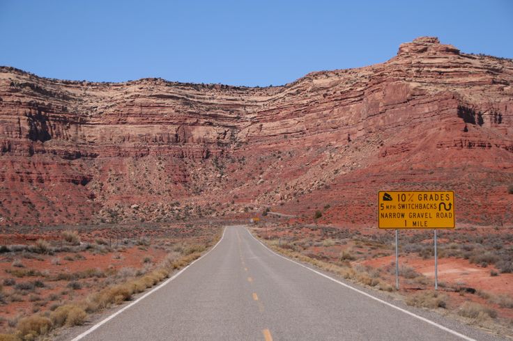
From Mesa Verde you take US 160 to Kayenta and head north to Monument Valley and Mexican Hat. The route then move north on 261 to UT 95 and Glen Canyon. WARNING! There is nothing out here and your gas tank is going to look small. Out of Mexican Hat, take 163 just 1/2 mile northeast and get gas at the Shell station. Failure to leave Mexican Hat without a full tank of gas could leave you stranded. Put in a Gas Stop on your route and don't forget. Your selected route UT-261 is an unpaved road north of Moki Dugway. The FJR can take the road, but if you're not comfortable on this kind of road, stay on 163 towards Blanding. Lots of ADV riders like 261.

I'll pick this up later.

 
Last edited by a moderator:
This is seriously interesting stuff. I might have to do this next time out that way. Reported to be "well graded dirt"

aca263c7ba504ca6ad18b06ec4908330.jpg


hwy261_003.jpg


mokee1.jpg


Tom

Perfect! I'll make the changes as you suggested. A lot of this was guessing and I didn't do Google Street View for everything. Going to spend another hour on the mapping tonight. Although I can reroute from the GPS, its a whole lot easier on the computer! I will forego the unpaved road; I don't need to dump the bike or suffer a flat tire a million miles from nowhere.

You responded again while I was typing - might have to give that a second thought. Incredible view!!! That is on the route I mapped? First picture didn't show on my computer. Edit: I could see it on my phone.

 
Last edited by a moderator:
Your route across Utah and Nevada looks good. I don't see you going down to the North Rim of GC. I agree it's 2-hours each way and you can decide when you get there.

At US-6 and CA-120, take 120 towards Lee Vining. Your route has you on Benton Crossing Road. That is a good road for finding the maximum speed of your bike, but 120 can offer a bit more fun.

You pass up Yosemite and cross on Sonora (108), then back over 88 over Kit Carson Pass and Luther Pass to South Lake Tahoe. Good choice following 89 along the west shore to Truckee, however take US 40 along Donner Lake and over old Donner Pass rather than I-80. Look for Donner Pass just south of your route and drag in a VIA. You're then taking CA-20 to Grass Valley, and have a waypoint for Doug. Good for you. You found Hwy 49 to Downieville and Gold Lake Road to Graeagle. You're as good as a native.

Your waypoint for Lassen National Park is mis-placed in the Lassen Nat'l Forest at the north end of Lake Almanor. Continue west on 36/89 and stay on 89 north to go through the park. You need a different waypoint here. Your loop around the park comes down the Mineral Viola Road. This is actually Forest Road 17 and is real dirt. Not a good option. After exiting Lassen Nat'l Park (assume your go south to north), take 44 west to Shingletown, then Black Butte Rd to Manton Road to Hwy 36. For some reason Garmin is allowing you to route dirt roads.

From Red Bluff you are on the famous Hwy 36 to Fortuna, north past Eureka and Crescent City to the Redwood Hwy. You will miss the Avenue of the Giants south of Fortuna, but no good way to backtrack. Do not try to take Alderpoint Road or other roads south of 36 to Garberville to pick it up, although a left turn out of Fortuna towards Garberville ride part of the Avenue is worthwhile. The Avenue of the Giants parallels 101 and riding it a ways south might be really cool. These are the largest Redwoods in the world here, and far better than Redwood Nat'l Park.

You turn north to Grants Pass and Crater Lake. Send a PM to FJRay for a waypoint. You are passing through LaPine, and should probably eat a Rueben sandwich. Then looks like a nice route through the Cascades, Washington, British Columbia and I don't know much about this area.

I'll try to look at the rest of it later.

 
The screen shot tells me what I wanted to know.

Tom - 10% grade on GRAVEL??? Have you got some dual sport tires in the top box?

 
I said to go another way (Blanding). In ideal weather, with an experienced rider, I say it can be done. The direction of travel however is uphill, and success is fleeting, and a turn-around is scary. NOT MY RECOMMENDATION unless the bike is a KTM or Tenere with appropriate tires. That is kinda like why I pointed it out.

However, I'd probably hit it anyway. Ask Wheatie whether dirt, snow and closed roads are a problem with me.

 
Last edited by a moderator:
If anyone was looking at my Spotwalla, it stopped displaying in Houlton ME. I forgot to turn on data roaming. Fixed and updated. Made it to Easton PA. Would have made it further except for heavy rain, construction and an additional tour when I missed an exit near New York. Lost at least an hour- and that was after getting a late start this AM. I hope to hit Skyline Drive by noon tomorrow. That's when this trip really starts.

 
Top