GPS Tablet

Yamaha FJR Motorcycle Forum

Help Support Yamaha FJR Motorcycle Forum:

This site may earn a commission from merchant affiliate links, including eBay, Amazon, and others.
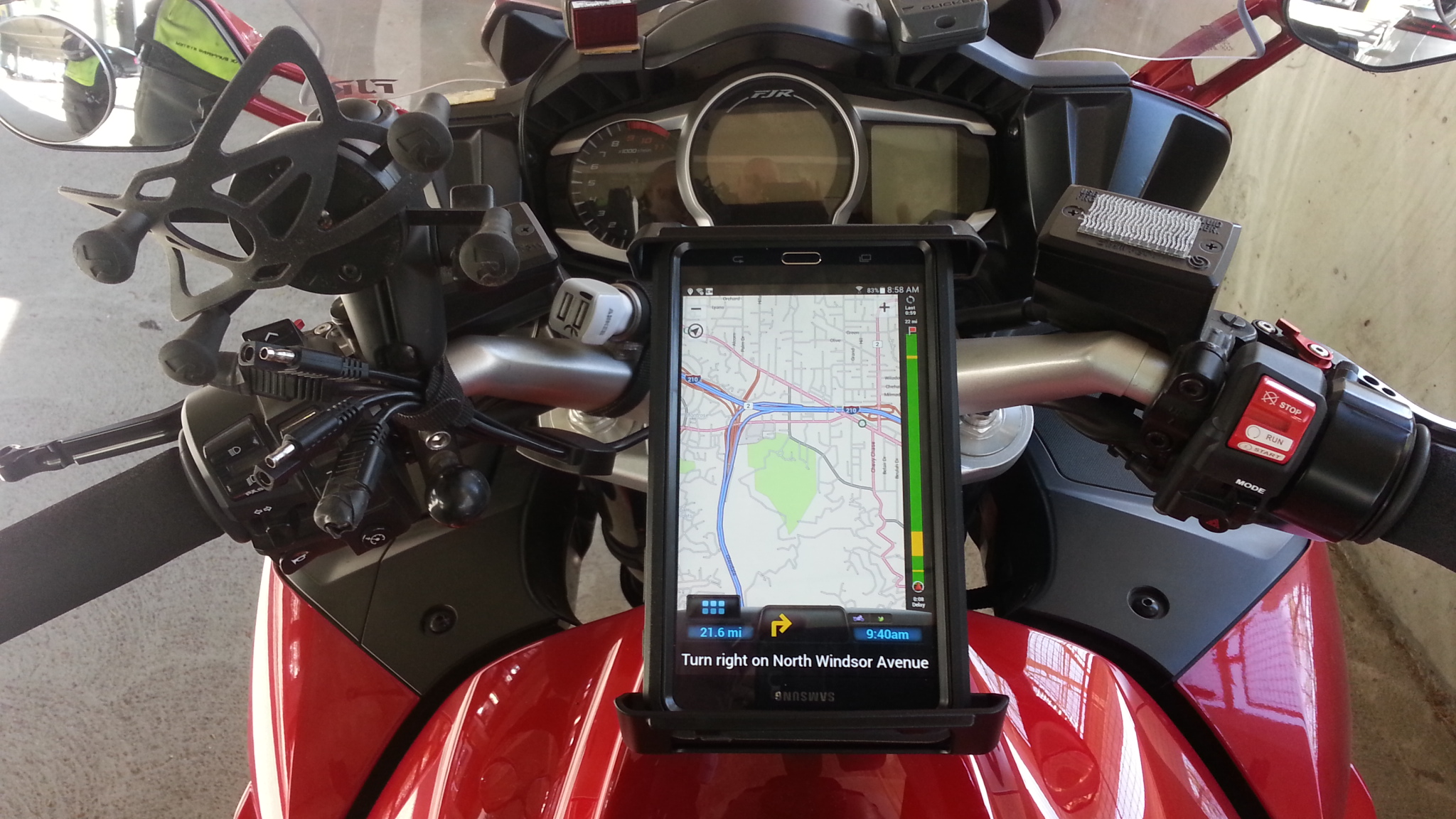
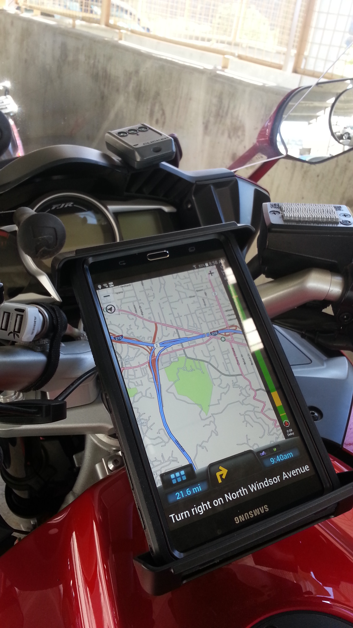
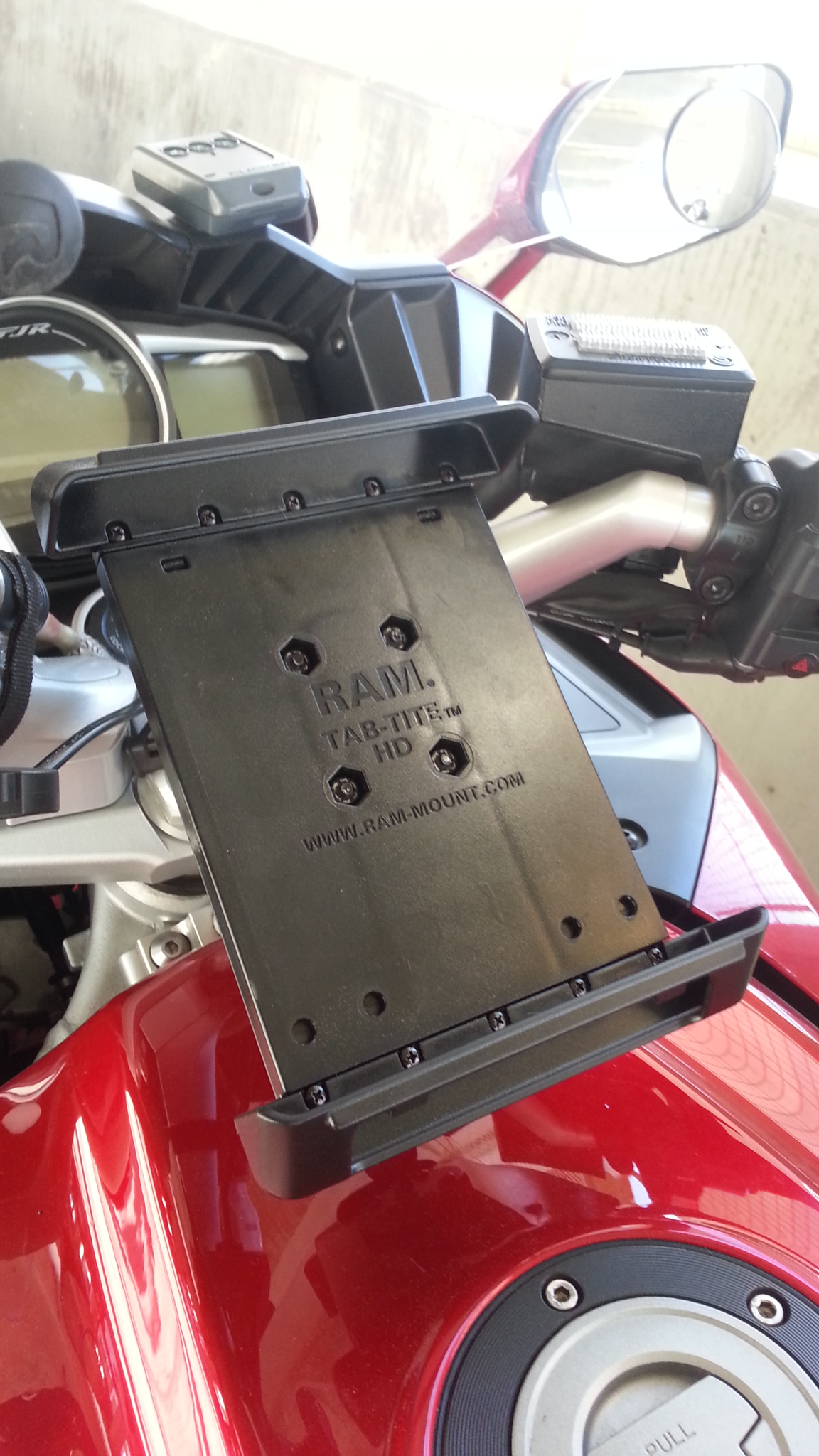
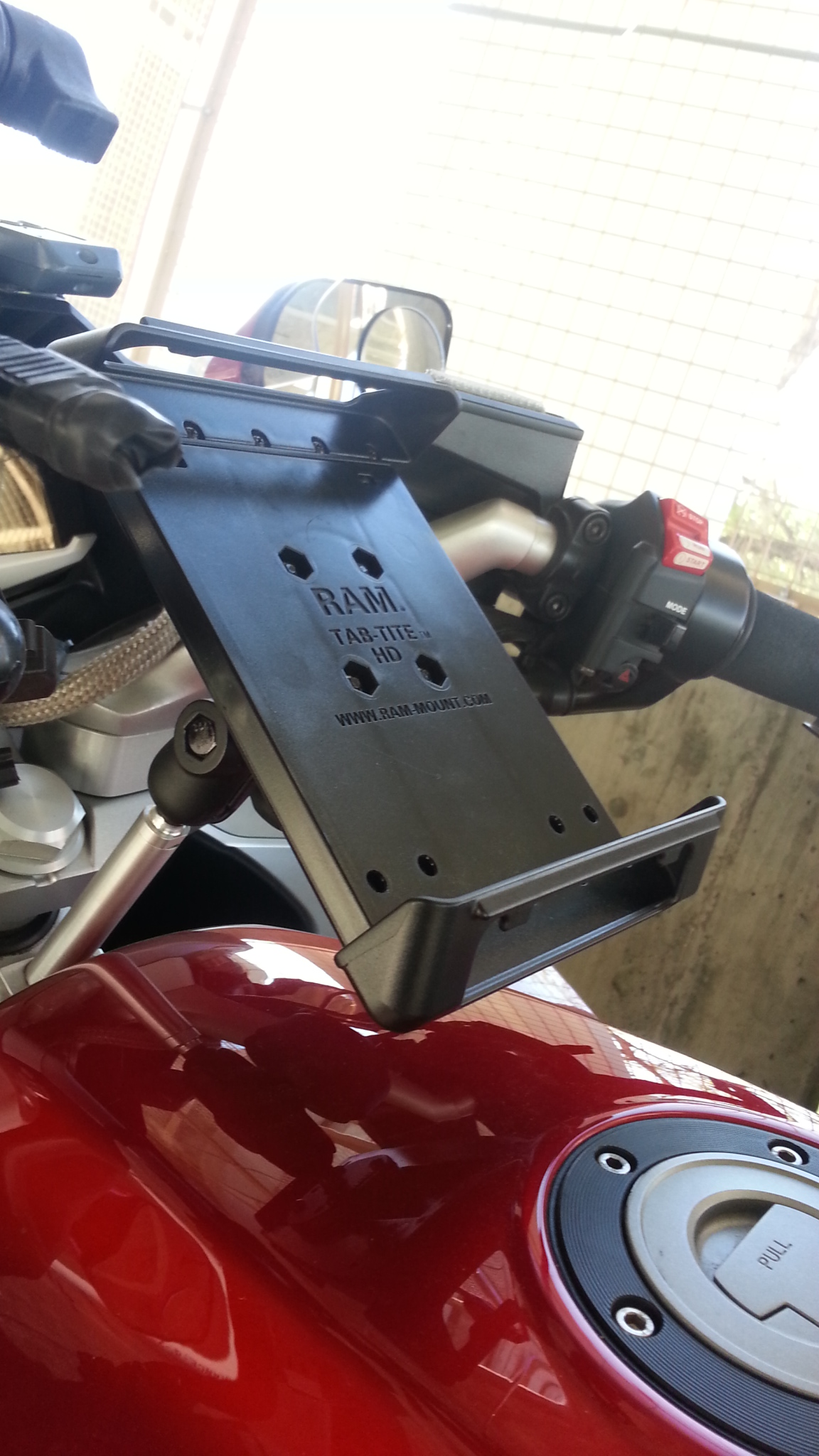
- I use the RAM tablet mount that's spring loaded. In and out in 5 seconds.

- I just got a brand new Samsung Tab 4 7" for US$ 130 shipped. Then plus the cost of the apps with lifetime maps update for a whopping $7.99 (CoPilot) or FREE (Mapfactor), while Garmin made their Lifetime maps sound like a very big deal, not sure why :)

 
Last edited by a moderator:
Yepper, price keeps dropping and the quality just gets better :) I think mine was a Tab2 back then. Dog food compared to today's tablets.

I have Co-Pilot on my phone (S6 edge plus), but I use Waze now most of the time. If it's up in the Mtns and no coverage, the CP comes back to life quickly.

 
Yepper, price keeps dropping and the quality just gets better
smile.png
I think mine was a Tab2 back then. Dog food compared to today's tablets.
I have Co-Pilot on my phone (S6 edge plus), but I use Waze now most of the time. If it's up in the Mtns and no coverage, the CP comes back to life quickly.
I have a Tab 2 too. It works like fine :) I got the Tab 4 then the Tab 2 goes in the car permanently, as GPS :)

Once you go tablet, you don't go back
smile.png


I use Waze on the tablet, connects to my phone as WiFi hotspot to get on the data network, then I don't have to use another mount for my phone.

 
Last edited by a moderator:
All I need is a device that works everywhere (not always in cell service), is waterproof, has nexrad radar that overlays my moving map, navigation that is easy to map, is XM radio compatible, doesn't use massive amounts of cell data, I can power from the bike for those 18hr rides and won't fail after the first year and 25k miles.

My Zumo 550 is acting increasingly goofy and I need to replace it, but I really like the XM radio attached to it and it hasn't actually failed me yet.

I'd use my $600 iPhone, but frankly it doesn't do well in continuous use situations. It gets hot in the sun and uses 1% battery per minute when not tethered to a charge cord when navigating. Even if I can find a waterproof cover that allows a charge cord plugged in full time, the phone still get ridiculously hot being used this way.

Honestly, the Zumo 665 is a great solution to my requirements, but it's discontinued and and will be unsupported soon. It seems silly to sink a boat load of money into an obsolete device.

The weather display and satellite radio are important to me and I haven't seen a great solution to this requirement.

 
Last edited by a moderator:
The weather display and satellite radio are important to me and I haven't seen a great solution to this requirement.
Staying out of the tablet vs GPS debate here but I too have always enjoyed XM and have had a SkyFi mounted for awhile now. Lately though I've been using their app bluethoothed (is that a word?) from my phone more and more. Not sure what their current subscription rates are but maybe another option for you?

 
I turned it upside down so I could press the soft/hard button easier, because I have a tank bag in front of it.

 
I imagine the power connection is on top, too -- away from the tank and tank bag. Looks good!

<Santa? Santa? Are you paying attention, man?>

 
Last edited by a moderator:
I imagine the power connection is on top, too -- away from the tank and tank bag. Looks good!
<Santa? Santa? Are you paying attention, man?>
That's correct. However, I don't even need to plug in to the power while riding. It last at least 7-8 hours per charge now (when it's still new).

I do have a cigarette plug to USB charger port right next to it if I need to :)

 
Last edited by a moderator:
I use a similar mount as Mike rider, but I use a NEXUS 7" tablet, with CO-Pilot. The NEXUS has a built-in GPS radio, no need for any cell service anywhere. I've had this waaaay out in the middle of nowhere (Anza-Borrego Desert) and no probs navigating to within inches. Only difficulty I've had is loading route maps onto Co-Pilot, but of course that may be due to my own cognitive deficiencies. Not waterproof, but I have tossed a ziplock bag over it's head in a pinch.

 
My first attempt a year and a half ago (Samsung Tab S 8.4"):

Android-Dash.jpg


Now working on fitting that AND the Samsung Tab S 10.1" on the new (to me) '12 Wing.

 
Hrm, you can find Nexus 7s super cheap.

So if I understand this correctly, the nexus 7 has a built in GPS sensor (like a Garmin), so I can use it in the middle of nowhere without cell service?

 
If you plan on putting it inside a case for weather protection, maybe fancy isn't needed.

I just got one of these for my 84 year old Mom and it's perfectly serviceable (as much so as an Android-based tablet can be
wink.png
).

It also has the additional benefit as not hurting so much if broken or stolen. They claim it's a 10" tablet but it's 16:9 so it's not as tall as it is wide.

https://www.amazon.com/DigiLand-10-1-Inch-Quad-Core-Touchscreen-Refurbished/dp/B00U6TGO5A?ie=UTF8&psc=1&redirect=true&ref_=oh_aui_detailpage_o02_s00

They also have other options out there.

https://www.amazon.com/DigiLand/b/ref=bl_dp_s_web_9714730011?ie=UTF8&node=9714730011&field-lbr_brands_browse-bin=DigiLand

 
Last edited by a moderator:
Excellent thread! You guys are onto something for sure.

Waze is a good product since it does such a good job at:

  • Looking out for police & radar traps (extremely important feature that works well with my radar detector)
  • Identifying traffic congestion (and re-routing)
  • Excellent general GPS functionality

Here's how I currently plan my GPS routes:

  • Use Google Maps on my PC or Laptop to plan each daily route. This is the time consuming hard work that makes or breaks that long weekend trip with your buddies. You'll be a hero if you plan it right or a zero if you don't.
  • $100 TomTom XXL 530S 5" GPS, Not waterproof but who cares? It's $80 for another refurb/used (keep a spare)
  • The free Tyre-To-Travel software (I actually paid for it recently although the free version is perfect!)
  • Procedure: Create your perfect route in Google Maps, Drag and Drop or Import it into Tyre, and one-button to copy to TomTom as an itinerary. This works extremely well and is very easy to do.
TyreTT runs circles around Garmin's Basecamp!.

QUESTION FOR TABLET OWNERS: what size screens are y'all using and are you happy at that size? or would something smaller or larger be better for you?

The use of tablets as some of you have done is a great idea! And very interesting!

 
Hrm, you can find Nexus 7s super cheap.
So if I understand this correctly, the nexus 7 has a built in GPS sensor (like a Garmin), so I can use it in the middle of nowhere without cell service?
7" might be a sweet spot for screen size :)

I believe the GPS will function in the middle of nowhere w/out cell service and Google Maps will also display your position correctly on a "dumb map" but anything that requires data will not show or work. So routing would be out. Waze would be practically useless without a internet data connection since it requires data for all its functionality except position.

 
Hrm, you can find Nexus 7s super cheap.
So if I understand this correctly, the nexus 7 has a built in GPS sensor (like a Garmin), so I can use it in the middle of nowhere without cell service?
7" might be a sweet spot for screen size
smile.png


I believe the GPS will function in the middle of nowhere w/out cell service and Google Maps will also display your position correctly on a "dumb map" but anything that requires data will not show or work. So routing would be out. Waze would be practically useless without a internet data connection since it requires data for all its functionality except position.
Thanks!

Saw a few 2013s on Craigslist for about $80. Not a bad deal, just gotta find a sandwich bag big enough to cover it if it rains.

 
I also find this very intriguing. I've checked out CoPilot and even went ahead and purchased it. I gotta say creating routes on my Note5 even though it's big is still a PIA. I'm reading of folks creating a map in Google which I must say is waaayyyy easier but what I don't get is how you export this map into CoPilot? That is the one crazy thing about Google is that it lets you create custom maps cut then you can't use them for turn by turn directions? Really weird. Anyway what am I missing? Thanks!!

 
Top