NWP Meet/Ride (Wellsboro PA) May 24-25,26 '14

Yamaha FJR Motorcycle Forum

Help Support Yamaha FJR Motorcycle Forum:

This site may earn a commission from merchant affiliate links, including eBay, Amazon, and others.
Anything you wanna bring is OK w me!

---Update---

OK, to quiet the requests for my day route (Sunday) or whenever you wish of course
wink.png


Hyner Long Loop (271mi) Download .gpx file here

Overview....

BigHynerLoop_zps35df3436.jpg


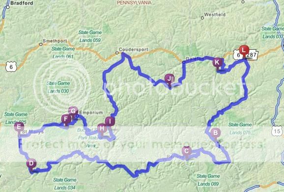
[C] Hyner View State Park (75mi from loop start). Kodak moment photo op.

[E] St. Mary's PA -Lunch stop? (160mi from loop start) Gunners Restaurant is one of many in this town

[F-G] Twisty run. My friends get to Emporium, turn around and do them in reverse and back. As always, your call

[K] Pennsylvania Grand Canyon. The last Kodak moment stop, right before we get back for our parking lot, tire kicking social hr!

For peeps that may want a shorter version so they can fit in some wifey shopping etc?

Hyner Short Loop (196mi) Download .gpx file here

Overview....

SmallHynerLoop_zps15ca0ea9.jpg


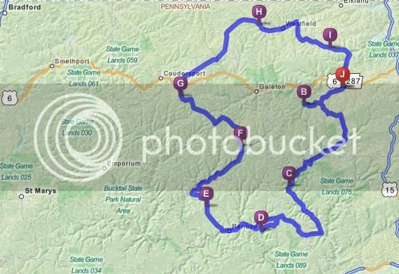
You'll miss out on some twisty roads but you still get both Parks for some Kodak memories to take home.

Pennsylvania Grand Canyon

[D] Hyner View State Park


After Waypoint (G), you could optionally take Rte 6 back to Wellsboro for even a shorter trip. This is not an exciting motorcycle road per-say, but it does have some shops that are area specific. The top part is more country rural riding anyways but way better than Rt6 if riding can come first.

 
Last edited by a moderator:
Hey KJ,

When I download your GPX route into my Garmin Basecamp, It shows up as a series of straight lines from point to point. Any idea on how to get the actual route on my GPS?

Thanks,

Jeff

 
Last edited by a moderator:
I opened it in Garmin basecamp and hit the recalculate option using Motorcycling icon and it routed over the roads.

Open route then double click it when it opens go to route options in the drop down menu select Motorcycling

Then to properties heading and at the bottom click on recalculate.

The above procedure corrected the straight line issue when I first opened up the route.

 
Hey KJ,
When I download your GPX route into my Garmin Basecamp, It shows up as a series of straight lines from point to point. Any idea on how to get the actual route on my GPS?

Thanks,

Jeff

Same issue for me as well
Thank you,

Tim

Sorry Jeff and Tim...

You can have BC Recalculate as per Tim ^ that will take it back to the roads vs. crow flys.

Basecamp is screwy like that sometimes. A talk with several this past Meet in Ohio, all came to the conclusion that BC is antiquated somewhat on imports/exports. OK, more bitched about just that
wink.png


So, another way is just import the .gpx file into Tyre (it's free proggy if you don't have it yet). Once in Tyre, the route can be correctly viewed and/or altered to your liking -AND- then directly exported to your Garmin device (there is a tab labeled "Garmin" to easily do this within the program). Tyre for Travel is specific for Motorcycles, and doesn't convolute the imports like BC. One note, you should alter the settings in Tyre to match your GPS (eg No Toll Roads, Ferry's etc.) Do this first thing before actually using the proggy.

Let me know if you have any probs. I'm sure most of you already have Tyre for Travel but if not, it's a worthy GPS plotter directed mostly towards motorcycling.

-KJ

 
Last edited by a moderator:
I should explain when/why the "straight lines" sometimes appear from WP to WP...

When I'm in BC and my GPS (Garmin/BMW Nav5) is plugged in, it uses the GPS' mapset. A much more detailed and better map than the normal default BC map. So when you see the .gpx file imported (with a discrepancy in mapsets), you get the straight line to WP's. HOWEVER!... you should see the actual route drawn in (maybe a dark gray line) following the actual roads/route. If you have/use the same mapset as I do, then there is no discrepancy's or straight lines of course, only the highlighted routes.

A double click on this dimmed (dark gray?) road/route will take you directly to the recalculate function (button). After recalculating, the (dark gray) dimmed out route should now become the highlighted route (I think Magenta is default color if you haven't changed it).

I still like Tyre for Travel as an added tool, check it out sometime
smile.png


Last edited by a moderator:
It's next weekend folks!

Attendees as of 05/17/14:

86Magna
njgtlrider - Wayne & Patti
KJ (Top_Speed) & maybe Debbie
DUSAK
Weavo53 & Wifey
Dave (Mavericktoo) & Marijo
odwa
Mike (Wine Guy) & maybe Donna
Mike (wnyfjr) & Laura

Steve (Flowback) may bring a roomie
Jeff (FJRPittsburgh)
Tim & Liana (madmudder)
Locomote & Lori (+ Beemer the dog)

 
Last edited by a moderator:
Had dinner in Wellsboro the other night and the bartender said next weekend will be happening down town with live music at a couple bars.

 
Had dinner in Wellsboro the other night and the bartender said next weekend will be happening down town with live music at a couple bars.
Thanx for the heads-up Steve, and since everything is within walking distance to our hotel.... well, hehe...
smile.png


Last edited by a moderator:
The wino wife and I be a little north of you guys Friday-Sunday...staying at a B & B on 414 in Hector, NY.
Yeah Joe, we'll be about 2hr south of you.

I take it you're on da 4 wheels and doing the wine trail thingy!. Well, one things for sure, you'll be getting SOD this upcoming weekend! ...cuz we all know where da wine goes with dem womens :) , yuup, straight down to the 3 corners of the world. I'd say loose as a NASCAR with a right rear going down... but I'll be nice! (today).

Have fun in my wino country :)

-KJ

 
Top