I Just Felt Like Riding

Yamaha FJR Motorcycle Forum

Help Support Yamaha FJR Motorcycle Forum:

This site may earn a commission from merchant affiliate links, including eBay, Amazon, and others.
Good looking RR so far Andy. Thanks for taking the time to pull it together!
coolsmiley02.gif
--G
+1

 
I was really worrying about whether you made it to Montrose for the first part of this, Andy, but then I rememembered, um, never mind.

Hope you come to Yosemite next year, even though you've got it colored in on your map already (but why orange? When the rest are red?) But it hurts me to see those big wide motorcycle lanes like these that you can't ride on in benighted states like Colorado. And Illinois and Ohio. And, you know, Texas. And, and . . .

Route 24 is kind of a main road into / through Colorado Springs. Traffic suddenly came to a stop in all lanes, and holy schnikes was it warm. Traffic was backed up for aboot 3 ½ miles. Route 24 was closed for construction. There was no warning, no signage in advance, no detour signs… Nothing. I was getting kinda pissed off, hot, and frustrated.


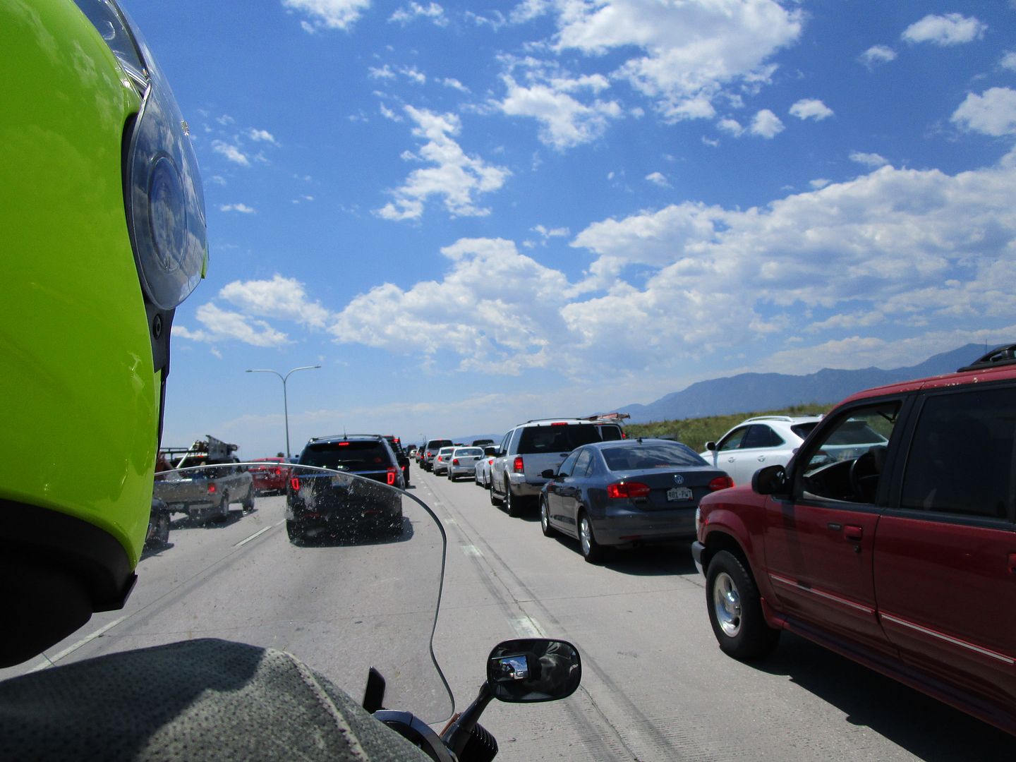
It took us an hour to get through that f’n place.

Screw you, Colorado Springs. If I never come back, I’m perfectly OK with that.
It's kind of cool to think I can ride exactly one mile and hop on US 50 from right here and get to Montrose that way. Or for that matter, to your place
smile.png
. And 50 doesn't suck out this way, either. At least in the mountains. But then, of course, we've got Nevada.
no2.gif


About the time we made it onto US Route 50 – which we could have taken all the way from Ohio to Montrose – both of our Sena headsets ran outta battery power. D’OH! Not sure why – we’ve ridden multiple days without charging them with no issues. My guess is the high heat impacted battery life, but what the hell do I know.

US 50 out here does not suck.
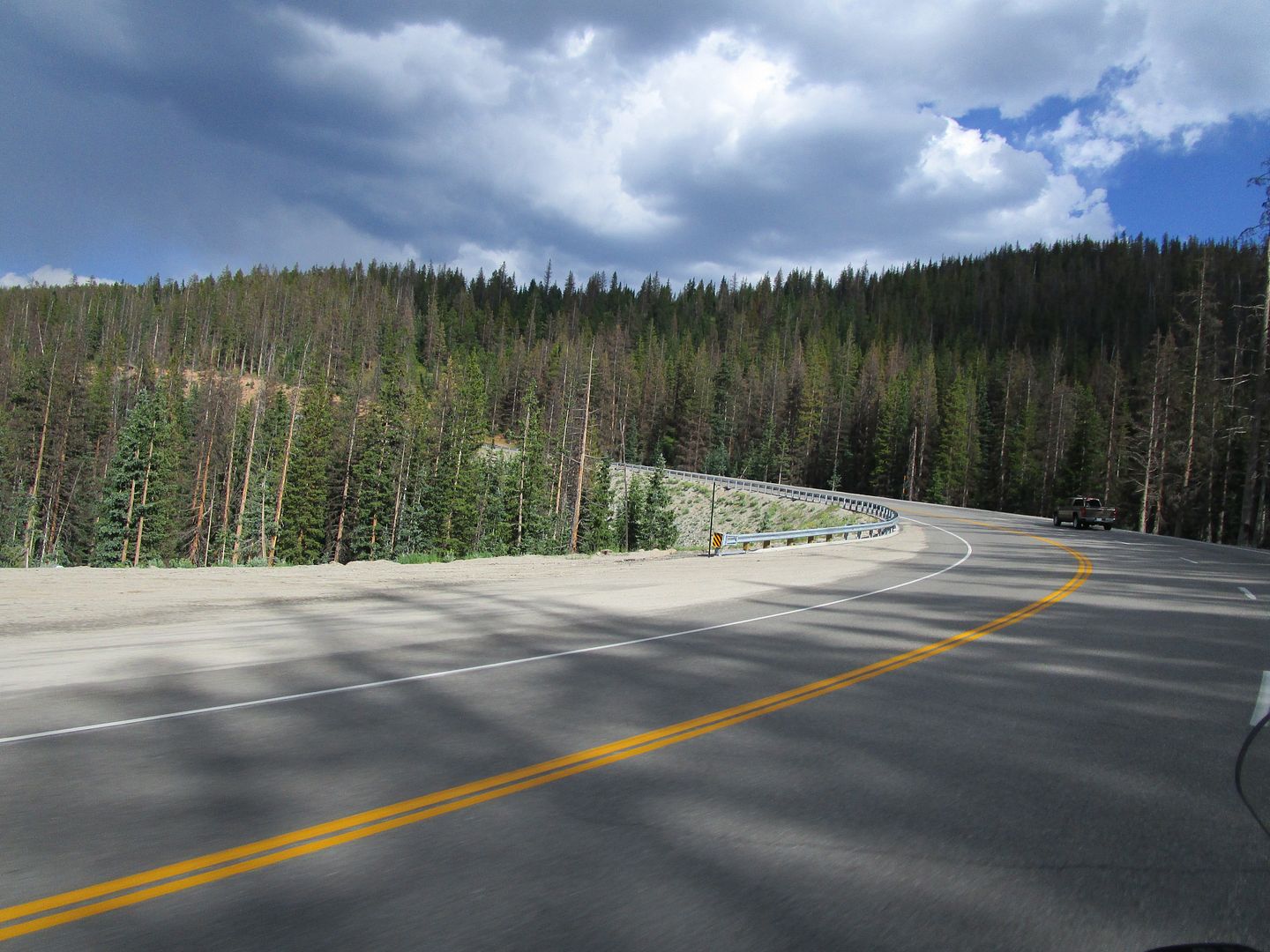
Anyhow, good go see you two again, and excellent RR so far.

 
Last edited by a moderator:
I was not far behind you on this stretch of US 50. The officer who spoke with me about my performance cited this as an example of why I should obey the speed limits. Yes, sir.

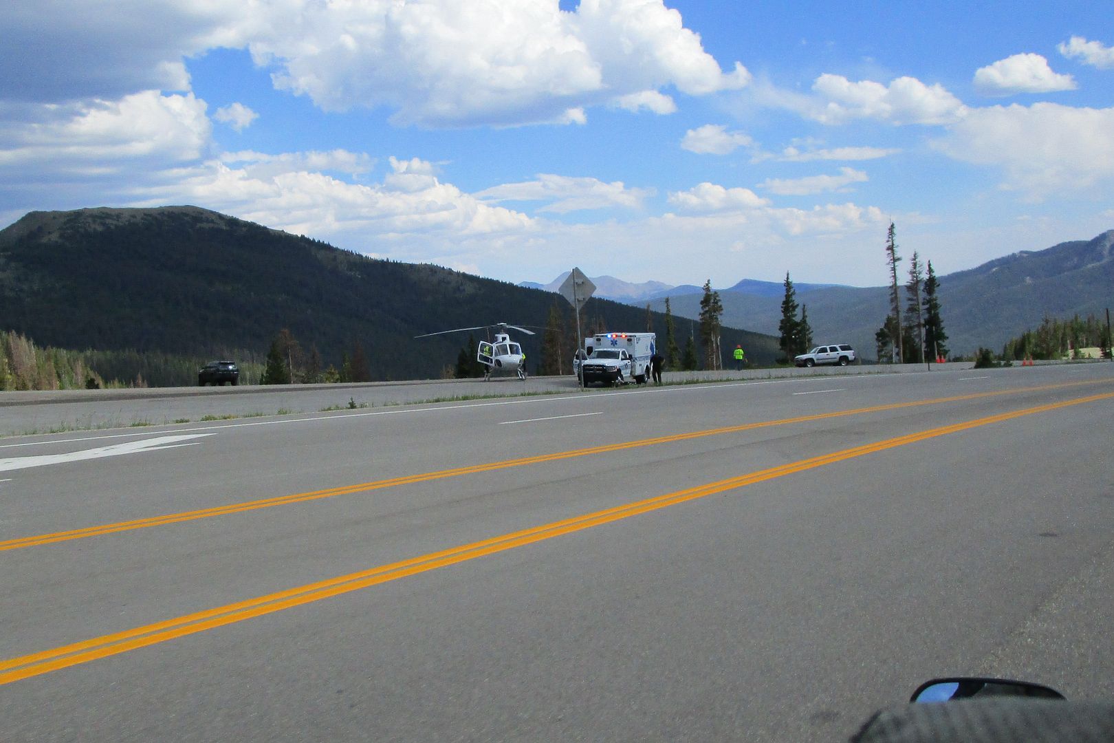
As we were rolling along, there were signs alerting us to an accident ahead and to expect delays.

Great.

Eventually we rolled up on this. NOT good. A Harley had run off the road and it looked like had run into the side of the mountain. The helicopter was just getting ready to take off. NOT good – I hope the passenger(s) came through OK.
 
One day, I'd like to meet you and Snooze. You seem to have great taste in Bikes, Beer, and BBQ. When it comes to friends, that should be more than enough.

Certainly subscribed....

 
The sky to the north continued to get gnarly looking.
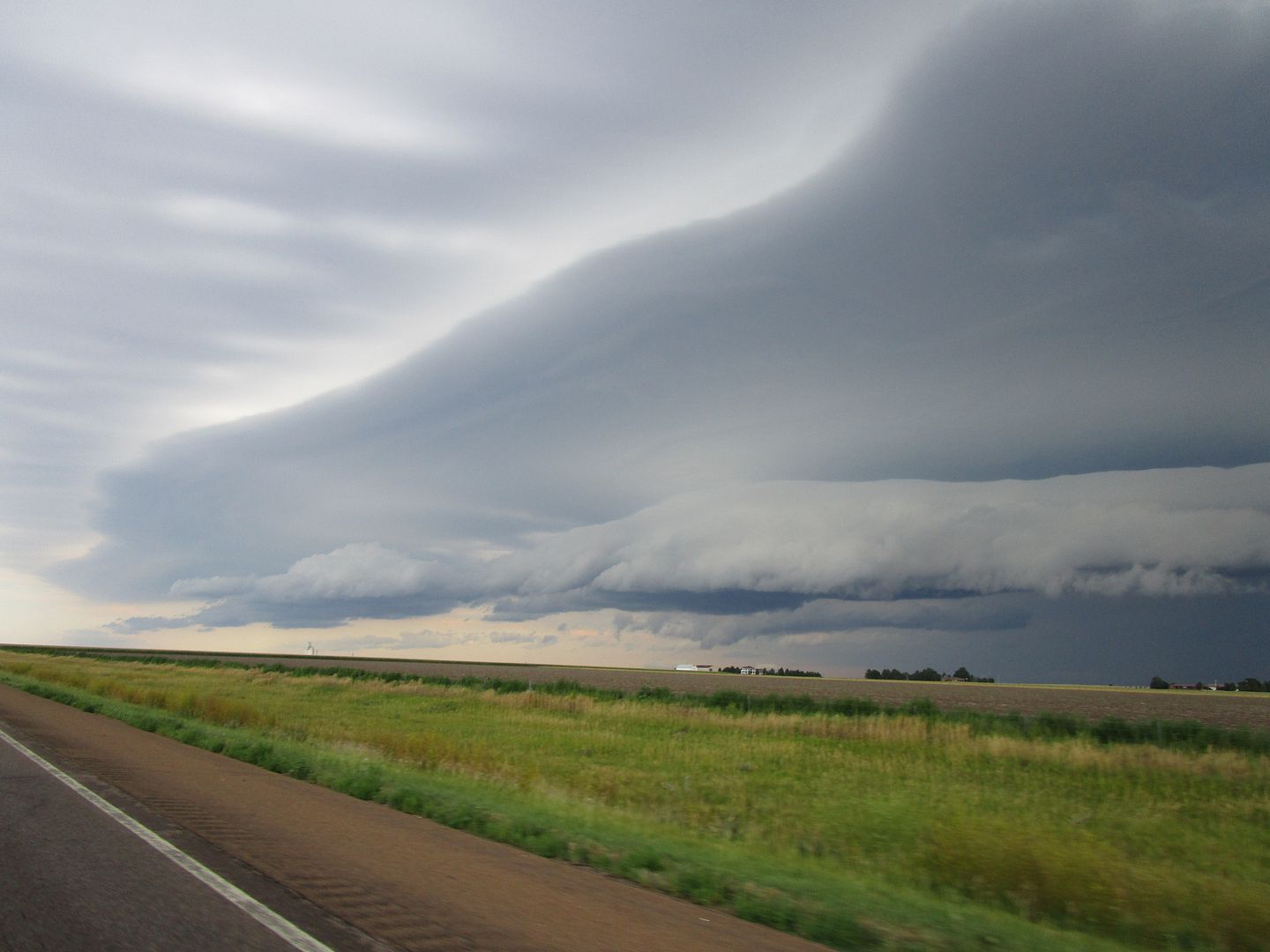
Cool picture!!
Picture? Yes.

Experiencing it real-time? Not so much. I was busy doing a balancing act of not letting the wind gusts blow us off the road / running as fast as was safe to do so / not getting blown off the road by the 18-wheelers / trying to calculate the intersection point between us and that storm, and making sure that intersection didn't actually happen. And, oh, yeah, trying to avoid a performance award.

 
Friday, July 29, 2016


After the long, hot slog yesterday, we were ready for a light riding day, but definitely wanted to go see some stuff.

We decided to head back east on Route 50 towards Gunnison and check out some other stuff in between Montrose and Gunnison.

So, we headed east outta town a little ways, and turned left.


One thing aboot this part of the country: free range critters. In this case, cows. Several of ‘em had our lane blocked, and there was one across the road. “Why did the free range cow cross the road?” Hell if I know, but I approached ‘em slowly and got the hell outta there.


We were headed here.


We stopped at pull-out and there was some information on the park.


And the views were rather impressive.


A little farther up the road, we stopped at the visitors center. We walked out there and got some funny looks since we were in full gear. At least we were protected in case … You know.


That is one seriously long-ass way down there, so watch that first step.


Selfie, with a random arm.


After getting some much-needed trash and trinkets from the visitors center, we headed up the road to see what else there was to see. Those rock faces in the distance were really cool due to the different colors & types of rock in the strata.


Out at the end of this particular road, the views were still pretty stunning.


Heading back down, we came down into the valley and contrast between the rocks and the green were remarkable, and the sprinkler just added to the effect, if ya ask me.


This guy was along the road. His right paw was up so I decided to give him an ‘air’ high-five. No, we didn’t plan this for a picture – it was just perfect timing.


We continued on our way back towards Gunnison, soaking in the scenery.


We hopped off of US50 onto 92 to check out the Gunnison River. The view to the left.


The view to the right.


If you have any dam questions of the dam tour…


If ya notice, there are cars parked along the road top-left-ish. Bottom-right-ish, you can see platforms where folks can walk down to the river-ish.


SELFIE!


The place wasn’t too crowded, although we did bump in to a couple other folks on FJRs. I think one was a figment of my imagination, though – he never gets to go anywhere.


After checking out the dam, we were back on our way towards Gunnison.


Now, I gotta say one thing aboot riding in this area.


OK, maybe two things.


You’ve prolly heard, “The pictures don’t do this place justice.” That, of course, is a given. But, to me, riding along this stretch of road was even more than that. To me, it was like … riding in a painting. Seriously! The colors were so insanely vibrant yet, at the same, muted in the way of pastel chalk art. We’ve ridden in our fair share of mountains before, ridden along oceans, gulfs and lakes, but this was different than any of that. Different, in the best kind of way. The kind way what you just have to experience for yourself.


Anyhoo. Enough of the namby-pamby existential shit, eh?

We’re not in Ohio any longer, for sure!


In Gunnison (which ain’t too big), we just kinda rode around a little bit and Sooze spotted a spot to have a spot of grub (see what I did there?). High Alpine Brewing Company in Gunnison, Colorado.

This picture makes me laugh, but only partially because I’m in it. Note the feller to my left, with his back to me. He was zonked out, forehead-down on the table. Sooze said he woke up for aboot 30 seconds when their food came. Otherwise, it was nappy time for him. We sampled some local craft brews.


And shared a pretty tasty pizza.


While we were waiting on our grub, a patron came in wondering if she could bring in her pup. They don’t allow pups inside, so she sat adjacent to us and tied up the pup just outside the door. The pup – a beautiful chocolate lab – sat and stood in doorway, looking at his hooman, wondering why he couldn’t come in. It was really cute to see.


After finishing up, we headed back to the bike.

Gunnison on a Friday afternoon.


Back on the bike, we headed out.


We hopped back on US50 towards Montrose.


The wind had kicked up a bit, and the lake was white-capping just a bit.


Just outside of Montrose, we spied this place on our way out. It is, seriously, a single-wide trailer, with a structure attached to it, with a little dome on it that can only be a telescope. If I were a betting man, I’d bet that the telescope cost more than everything else on the property combined.


Touring on a motorcycle is like nothing else. The sights… The sounds… The romance of the open road… The whole visceral experience… The … Laundry. Yes, it was laundry day. After our 165 mile jaunt to Gunnison and back, it was time to do some laundry and just relax a bit. Exciting, eh?

Once that bit of fun was addressed, we found the NAFO registration table. Or, as it appears to me, (from left to right), Mudslide, Intech, HotRodZilla, and 0face. Or, as it really is (from left to right), Mudslide, Dumb, Dumberer, and More Dumberer. And I wonder why I got the wrong size shirt…


Sooze and I had picked a place in town to eat but it was a bit farther than we wanted to walk, so after a quick consultation with the terrific front desk folks at the hotel, we called a cab. A pickup rolled in, so all eight of us piled in the cab and the bed and headed to Horsefly Brewery in Montrose for dinner.


We had some local craft brews as well as fried pickle spears…


I had the fried shwimps basket.


Sooze had a wrap.


We may have had a few laughs.


Just maybe.


But PhilJet just couldn’t keep his eyes open.


According to Julie, it appears that this bar stool is a mare. JSNS


After dinner, we called our cabbie, piled back into the pickup, got back to the hotel safe and sound, and called it a night.

 
1. First and foremost, you are doing great. I am loving this RR.

2. That is a lot of beer! No way I could drink that much and pilot my FJR anywhere.

3. Finally a picture of HER instead of YOU! Much nicer.

4. You have been misled. That is not really a Chocolate Lab. I have bitten several of them on the ears, and a couple on the ass and NONE of them tasted like chocolate. It is a lie.

5. That bunch at the registration table look a bit shady to me. I hope you paid cash and did not give them a credit card number.

I remember Gunnison as a pleasant little place. I have good memories of washing our bikes in the hotel parking lot.

 
"According to Julie, it appears that this bar stool is a mare. JSNS"

And we interrupt reading this ride report to grab a microcloth and wipe the Iced Tea from the computer screen. No - please don't wait for me. I'll be back shortly....

(HOLY COW - that was funny!)

 
Saturday, July 30, 2016


After our light riding day yesterday, we were ready to do a bit more. We spoke with our friends Tom (AKA huron52) and Pam last night and they were interested in riding with us. After a quick breakfast in the hotel, we wandered outside. They were getting ready to roll, so we jumped into our riding gear and got ready to roll as well.

The plan for this day was to ride US 550, AKA the Million Dollar Highway, south outta Montrose.

Tom and Pam.


Traffic wasn’t too stoopit for a Saturday morning, which was good.


A barn picture for Andrew.


This stream was cool as hell. As you can see, the water itself has a baby-puke-green hue to it. At times, though, when the water was shallow enough, the red color from the rocks in the stream shown through, giving a really interesting color combination.


One little town we rode through was Ouray. It was like riding through a movie set.


Once through Ouray, we began to climb towards the Million Dollar Highway.


Tom pulled off for some photos.

Where we came from.


Where we’re going.


There was a pretty significant waterfall that went down a looooooooooong way.


SELFIE!


And now … for the fun part!

If you are not familiar with / have not heard of the Million Dollar Highway, there are a couple of things to keep in mind:
1. It’s a road carved into the side of mountains.
2. There are no guardrails.
3. There are no shoulders.
4. You are on a road CARVED INTO THE SIDE OF MOUNTAINS.

Which means, in a nutshell, this is NOT a road to lose concentration on, which is difficult because the views are absolutely stunning.

Heading south, this portion has the mountain face to the left and a sheer dropoff to the right.


No shoulder… No guardrail… Just down.


When Sooze and I rode the Pacific Coast Highway back in 2010, I remember looking at her pictures and asking, “Where the hell was this? I didn’t see that!” and her response was, “Well, NO, because you were busy making sure we didn’t wreck.” Good point! So I was confident that Sooze would get some pictures ‘cause I was completely focused on the road.


The speed limit through this section is only 25, and I’m pretty sure we didn’t go much over that.


Eventually we made our way through that fun-filled section and continued winding our way south, just enjoying the day.


Yep – you’re reading it right. 10 MpH switchbacks ahead.


Lotsa trails to pull off onto, but not while two-up on an FJR.


Note the road ahead and down to the left. We’ll be there shortly.


At one point, the altimeter on my GPS showed us at over 11,000 feet. It had cooled off quite a bit that high, and as we dropped back down, the temperature warmed back up a tad.


The contrast between the blue of the sky, the shades of green of the foliage, and the red of the rocks were really something.


Tom pulled off at the Molas Pass Summit for some pitchers.


“Who, me? I never get to go anywhere.” Riiiight-oh, Tom.


Tom and Pam.


This place was pretty hopping.


The lighting for this picture kinda makes it look Photochopped, but it’s really not!


There is a campground down by that lake – that’d be a heckuva to camp / glamp.


Top