What do you use for trip planning?

Yamaha FJR Motorcycle Forum

Help Support Yamaha FJR Motorcycle Forum:

This site may earn a commission from merchant affiliate links, including eBay, Amazon, and others.

s.ga.rider

Well-known member
Joined
Jul 22, 2010
Messages
375
Reaction score
63
Location
South Georgia
Any apps to use besides maps and map quest? I'm looking to plan around 500 mile a day stop points along my route and get a game plan for a 3 week trip.

 
I just spend a little time on Google before I leave then paper maps on the road when by myself. Hope for the best plan for the worst and enjoy the ride.

 
I use and have grown to love Furkot. I currently have dozens of potential trips saved in the app and am using it now as we are halfway through a 3,500 family road trip as I type this.

Once I have a trip mapped out in the application, I can export it in GPX or a number of other file types for use with various SatNav units. I can use the app to plan gas stops automatically by telling it my fuel range per tank. If I give it the number of hours I want to travel per day, it will automatically offer lodging options which can be booked directly from within the app. Furkot is completely free to use and there are zero adds.

The screen shot below is a trip that I would like to take this summer. It's a 1,300 mile four day/three night loop through Wisconsin and the U.P. of Michigan. I hand selected every segment, choosing scenic byways and such where available, and avoiding all interstates. I colored each day's leg with alternating colors to make it easy to see the daily route. I allowed the app to suggest lodging, which are designated by the three yellowish colored icons along the route.

Screen%20Shot%202016-03-25%20at%2010.52.02%20PM_zpsj0om30qx.png


The developers are a small company of web coders who love to travel and they are very responsive to inquiries. I would not say the learning curve is steep necessarily, but it does take a willingness to dive into the app and invest some time learning how it works. Here's a decent intro to the app on YouTube:

It's probably not for everyone, but if you're like me and actually enjoy the planning aspects of road trips, it's a fantastic platform to use. I am basically addicted to it and just wish I had the time to take all of the trips I have put together with the app.
biggrin.png
 
Pick areas that I've always wanted to see. Use Gazetters, maps and Microsoft Streets and Trips to plan the most rural squiggly way to get there and back. Bring maps along and GPS if you have it.

 
I google, use travel sites on the internet, get free maps from the state highway departments of the states I will be visiting and word of mouth.

 
Like Wheatie, I love using Microsoft Streets & Trips for pre-planning, then plugging my routes into my Garmin software. Unfortunately, Microsoft S and T's has been discontinued. I bought the last version they made in '13, but I still use it all the time. I would plan for certain destinations for most of your trip each day but I wouldn't recommend making hotel reservations at any of them. Reason being, if you don't make it to a certain destination during one of your days, the whole rest of your trip destinations can be thrown off and you will pay dearly in cancellation fees. (Yes, I learned that the hard way myself!)

Tiger's Furkot app looks very user friendly, as well.

 
Drag a route using Google Maps (needs a real computer, not a tablet). Then use my on-line utility to convert the URL to an itinerary file for my Tomtom. There are utilities out there that would convert the Google URL to files for other satnavs.

 
Last edited by a moderator:
For a quick overview and very preliminary planning, Google maps is probably the quickest. I will often mark points on the map and "connect the dots". It is severely limited because the number of waypoints is restricted to something like 15 or so (can't remember)which isn't much good for a long trip unless its a direct route. Also, GM doesn't download directly to GPS. Very easy to use and "Street View" in invaluable in planning. I use this in conjunction with other programs.

Microsoft Streets and Trips is still pretty good for planning although it is no longer available and maps cannot be updated. Simple and intuitive to use and you can download your routes to your GPS - hopefully you won't have a map mismatch (Check in detail after download!). Big advantage with S&T is that it "lives" on your laptop with no need to have an internet connection to create or modify maps on the road. Creating a complex route from scratch on a Zumo isn't much fun.

The Gold Standard is, of course, Garmin Basecamp although I sometimes use the older Mapsource which is no longer supported by Garmin. (For something simpler, Mapsource gets the nod.) Basecamp is not particularly intuitive but is very capable. Fairly steep learning curve which is VERY much helped by Easy Ed's tutorial. https://www.newenglandriders.org/Learn_BaseCamp_PC.pdf Also available for Apple.

I will have to have a look at Furkot as posted by Tiger_993, above.

 
I use, in this order:

1. This forum's Ride Report section

2. Youtube

3. Google Maps/Google Maps Streetview

4. Mapquest

5. Paper Maps/State Road Atlas

That gets me through the planning stage. I use the Garmin Zumo 660 and my phone while on the road but the planning part is mostly done before I leave the house.

I would suggest to the OP to not plan days based on miles, but to plan based on time. There will be lots of motorcycle days that will take all your energy and all the available daylight but will not come close to 500 miles. Those are usually the best motorcycle days.

 
Once I decide general direction and places... I use MS Streets & Trips to figure out most details of the route--I like it's 'break after xx:xx' and 'start time' functions, although I find the interface quirky. Then, I rebuild the route in Garmin Mapsource (not Basecamp), which has its own quirks.

 
There will be lots of motorcycle days that will take all your energy and all the available daylight but will not come close to 500 miles. Those are usually the best motorcycle days.
Absolutely agree. I've spent a full day on the freeway covering many, many miles and been ready for more. I've also spent a day charging through the mountains doing less than half the miles and been flat worn out.

It depends on both the physical AND mental effort required. Things like tight curves, heavy traffic and bad road surfaces demand constant mental effort. Concentrating for hours is exhausting.

 
Drag a route using Google Maps (needs a real computer, not a tablet). Then use my on-line utility to convert the URL to an itinerary file for my Tomtom. There are utilities out there that would convert the Google URL to files for other satnavs.
This is very similar to the process I use. Drawing the route up in googlemaps allows for easily sharing it with others to get their input, too, which is nice, given that the guy I plan most with is about 3 hours away. We then export this data from google into an app called CoPilot, which we both have on our phones, and setup on our bikes so that we get turn by turn directions in the speakers in our helmets.

Aside from just choosing twisty looking roads on googlemaps, we also use motorcycleroads.com and input from members of a variety of forums when planning trips. The rides reports sections of forums are typically full of good information if you've already got certain destinations in mind.

For a quick overview and very preliminary planning, Google maps is probably the quickest. I will often mark points on the map and "connect the dots". It is severely limited because the number of waypoints is restricted to something like 15 or so (can't remember)which isn't much good for a long trip unless its a direct route. Also, GM doesn't download directly to GPS. Very easy to use and "Street View" in invaluable in planning. I use this in conjunction with other programs.
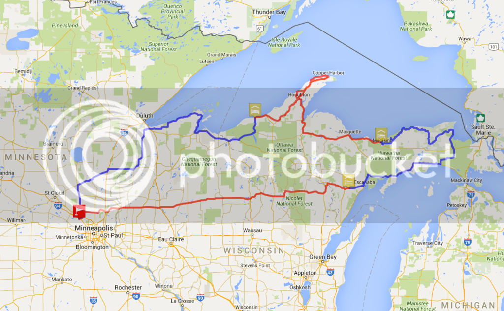
While it does (now) limit your number of waypoints, you can add another layer and start counting again. I'm not sure how this will work when exporting to another file format, as I haven't tried it yet, but here's a link to one I started planning last weekend which uses multiple layers to get the entire route together (except from point 10 back to point 1, google doesn't seem to believe that there's a ferry there).

 
I use Google Maps or Bing Maps to plan initial route, then input my stops, motels etc and road intersections into my TomTom, sometimes using Tyre, other times just keking in the data. I keep a paper map folded open to the appropriate area in my tank bag map holder for reference. If I get into stop and go traffic I'll use the Nav on my phone, which shows stoppages and delays better than the TomTom, to try and avoid the mess.

When I'm traveling with Festar we alternate which GPS we follow, one intersection we follow my directions, the next we follow his. Not been lost yet.

 
Thanks for the tips. Most of the trip is going to be unplanned but was trying to find camp sites around 500 mile intervals till I get out west.

 
"What do you use for trip planning?" My wife. She always tells me where to go.

Seriously though, she does our route planning with input from me. She uses mostly paper maps and has a file drawer full of travel information she's been collecting over the years, a lot of it with after-trip notations. Her organizational skills compensate for my ADD.

 
Top