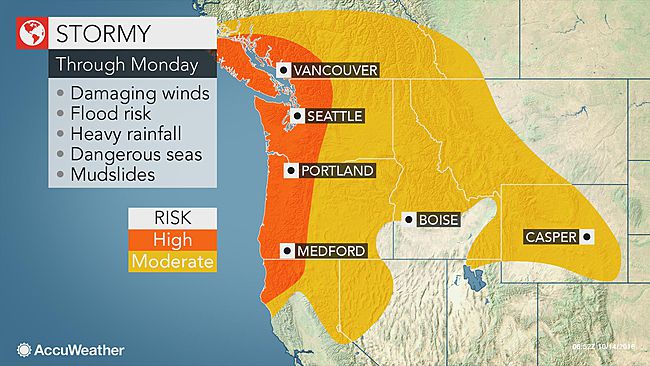
A train of storms will pound the northwestern United States with flooding, dangerous surf and hurricane-force winds into early next week.
The most severe impacts will be felt from southwestern British Columbia through western Washington and Oregon and into northern California as several Pacific storms barrel onshore through Tuesday.
Residents in and around these areas should be aware of the threat for urban and coastal flooding, mudslides, washed-out roads, power outages, property damage and travel disruptions during the onslaught.
The combination of rain, wind and poor visibility could make travel very hazardous on area highways.
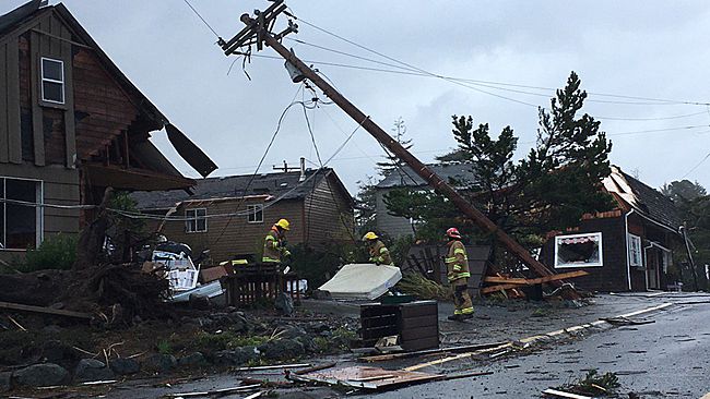
The National Weather Service in Portland, Oregon, confirmed two tornadoes along the Oregon coast early on Friday. One was reported in the town of Manzanita, while the other touched down in the community of Oceanside.
A waterspout moved onshore near Manzanita, Oregon, Friday morning and caused some damage to the town. (Photo/Twitter/@molfamily via Storyful)
On Thursday night, the winds proved to be too strong for many trees and power lines across the region. Over 7,800 Portland General Electric customers were without power around 3 am PDT on Friday. That number has slightly improved since then and is around 2,000 customers as of 10:30 am PDT Friday. In Lebanon, Oregon, roughly 1,500 customers were without power as of this same time.
Farther north, gusty winds are also causing issues. In the Seattle area, more than 35,000 customers were without power as of 5 p.m. PDT Friday, according to Puget Sound Energy.
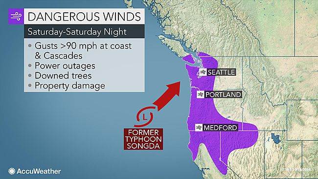
Once-Super Typhoon Songda to unleash hurricane-force conditions this weekend
As quickly as the first storm exits, the second, more powerful storm will follow on its heels from Saturday to Sunday.
This next storm will contain the remnant circulation of once-Super Typhoon Songda, which curved away from Japan earlier this week.
While the storm is not expected to be tropical in nature by the time it reaches the Pacific Northwest, the impacts could still be similar to that of a hurricane, according to AccuWeather Senior Meteorologist Alex Sosnowski.
Gusts from 75 to 100 mph will occur in some coastal areas. Additional tree and power line damage and power outages are likely.
"The storm this weekend could hit some areas like a sledgehammer," Sosnowski said.
"The heaviest rain and highest winds will come onshore Saturday afternoon along the Washington, Oregon and northern California coasts," according to AccuWeather Senior Meteorologist Dan Pydynowski. "A general 2 to 4 inches of rain will fall across the region, with higher amounts in the coastal ranges."
"Flooding will certainly be a concern after much of this same region is getting inundated with several inches of rain to end the workweek," he added.
Residents should clear debris out of storm drains to help prevent an overflow of water onto streets and lands.
Motorists should prepare for slow travel and possible road closures. Never attempt to drive through a flooded roadway as the water may be higher than it appears and the roadway underneath could be compromised.