SE Ohio / W Virginia RAMBLE 4/30-5/03 '15

Yamaha FJR Motorcycle Forum

Help Support Yamaha FJR Motorcycle Forum:

This site may earn a commission from merchant affiliate links, including eBay, Amazon, and others.
Who's going out Fri. Morning from MW. There's 3 of us who are looking for a Tour Guide on Fri. for WV. That being said, if we get no takers and anybody there wants to ride the SEO routes any of us could certainly lead that Twisty Adventure. See everybody this weekend.

Dastardly Dave

 
OK, I finally got off the fence and registered. I supposedly got a room at the Microtel for Friday and Saturday nights (have confirmation number, just waiting for the email). I'll be heading down on Friday. Sadly, I can't leave any earlier.
upset.gif


Since KJ and the Canadian contingent seems to embarking on Thursday, I guess I'll be heading down alone. Not sure what route I'll take. Might just depend on what time I actually go KSU.

 
I'll be heading down Friday as well, if anyone would like to meet up at the Beallsville Diner for lunch...let me know.

 
Last edited by a moderator:
OK, I finally got off the fence and registered. I supposedly got a room at the Microtel for Friday and Saturday nights (have confirmation number, just waiting for the email). I'll be heading down on Friday. Sadly, I can't leave any earlier.
upset.gif

Since KJ and the Canadian contingent seems to embarking on Thursday, I guess I'll be heading down alone. Not sure what route I'll take. Might just depend on what time I actually go KSU.
I'll be leaving Southern Ontario Friday AM. If you like, I can swing by Eden and pick you up. I think I'm gonna run down 62 until it meets up with I79. I've just done that boring I90-I79 thing to many times. But I may just say piss on it and do it again. I'll drop you a PM with my cell.

 
Plan A is to arrive on Thursday.
Meetup w me (or also maybe Madmudder and Wine Guy) on the way down ... U hoser! No Steamer so we don't have any winerz.

¥¥¥¥¥¥¥ ROUTE UPDATE ¥¥¥¥¥¥¥

Allen has informed me that on Sweet-16 Loop, his Tyre for Travel is indicating a possible dirt road?

After investigation, and btw he said don't bother w it KJ... But, I have to at least start out with a no stone unturned mentality.
wink.png


It appears BC has wrote in a 50 yard stretch of a road, more so a "Y" where the Route goes to the left Y, but also shows a 50yd stretch to the right. Yes, this is gravel, confirmed by Google Earth View. This should not pose a problem however... Unless u have your GPS zoomed in like to see road midgets or something!

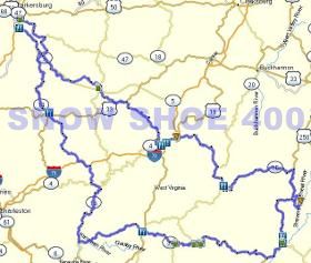
So let me lay it out. Sweet-16 loop runs CCW. Starts on 14 for exactly 14 miles, then 53 to 47 which lands u on 16. On the return side u go up 219. At Mill Creek, u turn left and start your trek back west towards Stonwall Jackson SP. at this intersection/ turnoff however way prior just past Mill Creek, the slight glitch is 3.5 miles after the turnoff from 219. Stay to the left fork and u will be fine. Overall this Y glitch or spot is exactly 261.8 miles into the route.

Anything else justa holla!

-KJ
Question: Does Sweet16 have an intentional right turn off of Hevetia-Adolph onto Carter at 293 miles?

I ask to see if this is something that happened when I recalculated Sweet16 to get TxT to show up. I find one more thing that I don't like about BC. In MS I could copy a route and paste it in a new file, mess with it (recalculate etc), and then compare it to the original. In BC any change made to a route in one list saves as you go along and affects that route in all lists. Hmmm.......As I type this I recall using the "duplicate" function in BC on a route. Example: If I duplicate Sweet16 the duplicate would be named Sweet16 (1). I guess I could monkey with Sweet16 (1) without affecting the original Sweet16?

I'm off to find a BaseCamp thread now.

Edited for 2 more Sweet16 questions: Left onto Butcher Fork at 328 miles? Here the route and track diverge. The info on the Ramble website route page says that the route is the safe bet when the route and track split. At 328 miles I think I'd rather follow the track than the route. Why the route AND the track in the route files? Is the track what you've actually ridden and then converted to a route?

Not trying to nitpick here, just working through big routes using BC for the first time (2015.4 maps). Thanks for your time, effort and patience. Just say "get lost" if you've reached the point of not having any more time to worry about routes or answer dumb questions and I'll understand
smile.png


Last edited by a moderator:
Maybe it's me, but the Ohio routes can't be found??
That's okay...I'll try to go from memory...what could go wrong?
Here are the 2014 SE Ohio routes from my archives if that is any help to you. They are in Garmin GDB file format and are supplied in an "As Is" condition.

I accept no responsibility as to the accuracy of these routes though I know you will blame me anyways when it all goes off the rails.

2014 SE Ohio Garmin files
I went through all the routes tonight and made repairs. Many waypoints and via were smack in the middle of intersections and some were off-road. I also adjusted routes to start and end in Mineral wells If you use these, be sure to review and recalculate for 2015.4 maps.

 
The old 2014 Routes (link) is now back up on the site. They were a bit buggy as Tom mentioned^. If he sends me the re-routed versions to the 2015.40 mapset... I'll replace those links with these.

We've had a few late attendee additions, no problem and much welcomed! So I'll bring along some blank name tags as my print job has now since past (I'm on to utter tings).

 
Last edited by a moderator:
Tim (madmudder) is meeting me at the Kennedy St Cafe at 8am Thursday. Anyone else from this way is welcome to join us, we'll run about 10 (GPS speed) over the posted, which is about 14 over on your dream-o-meter.

We are routing down thru 219 and onto 50, avoiding slab (except some of 219 that cuts in/out). Post-up or PM me!

 
Last edited by a moderator:
The old 2014 Routes (link) is now back up on the site. They were a bit buggy as Tom mentioned^. If he sends me the re-routed versions to the 2015.40 mapset... I'll replace those links with these.
We've had a few late attendee additions, no problem and much welcomed! So I'll bring along some blank name tags as my print job has now since past (I'm on to utter tings).
You need to put the Spotwalla info on the first post and on the website. I know I had to dig for it when I wanted to join. JS...
K, will post the Spotwalla group link on the first post here.. It's on the GPS page on the website towards the bottom.

<edit in> Done!

 
Last edited by a moderator:
The old 2014 Routes (link) is now back up on the site. They were a bit buggy as Tom mentioned^. If he sends me the re-routed versions to the 2015.40 mapset... I'll replace those links with these.
We've had a few late attendee additions, no problem and much welcomed! So I'll bring along some blank name tags as my print job has now since past (I'm on to utter tings).
You need to put the Spotwalla info on the first post and on the website. I know I had to dig for it when I wanted to join. JS...
K, will post the Spotwalla group link on the first post here.. It's on the GPS page on the website towards the bottom.

<edit in> Done!
Guess I didn't scroll all the way down. Thanks! I will be looking at the Snowshoe route to see what a good place to meet that would work for both of us. What time do you plan on leaving MW? We can't rely on cell service for calls or data in that area. Still affected by Greenbank.
No prob, it was way down (almost hidden I guess) to the bottom of that page.

I'm thinking little to no cell as well. Which shoots-up the Spotwalla Group page that we could of used (still maybe can in a populated area). I will PM you my text number anyways.

This could be fun and challenging; as to the coordination of this without all the telemetry I'm used to. Hmmm!? I (or we) can depart MIcrotel Friday AM early. The loop runs CCW. So are you thinking of meeting before Snowshoe or after?. I'll have to go back into BC and seek mileage to your meet-up point, and calibrate the leave time from that.

Here's the (small) visual on that loop, Snowshoe is far right and the small loop thru the mountain is actually cut-off in the image....

624562_1320053_55350d9cde0a9.jpg


Last edited by a moderator:
A preliminary calculation indicates that Snowshoe around noon looks reasonable. We could meet at the top in the 12-12:30 range if that would work for you. I think that is doable with 7:30-8:00 AM take off for you.

 
A preliminary calculation indicates that Snowshoe around noon looks reasonable. We could meet at the top in the 12-12:30 range if that would work for you. I think that is doable with 7:30-8:00 AM take off for you.
That would work. If I remember correctly, there was a pizza joint just down the ski-slope mountain. That may be a lunch meeting spot if OK with you. If so I'll get the demographics down and to ya!

Thanks KJ!
We may even have those 2014 routes revised to 2015.40 mapsets (courtesy of TominPACA), not sure if your current on the map updates or not, if not, you may want to stay with the 2014 ones posted. I know you said you wanted to keep WV for OEM. Understandably, but these loops are on the N/W part of WV, where-as OEM's routes will be much more East and South of our SEO '15 loca.

Just a thought, and I did-up some SE Ohio Loops as well, all listed on the site. And Mark, I know you'll wanna do up a weanie run/loop
smile.png


Last edited by a moderator:
Top