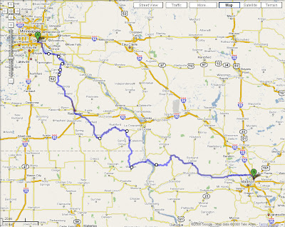
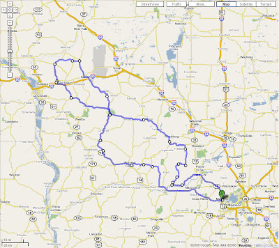
Ok. Below is the final Saturday route map. While
there have been no change to the planned roads, I have included stops for a morning break, a lunch/refuel break, and an afternoon break. Of course, after both pass-thrus of Wildcat, we most likely will have an impromptu stop at either end to regroup and consider circling back for another pass!

Also, updated turn-by-turn directions (with mileage and time estimates reflecting the stops) are below. Remember that time estimates will undoubtedly continue to get off-track as the day progresses. Gotta be flexible.
The circled locations denote the planned stops and lunch break at A&W. There are a few places near the A&W in Sparta to refuel. The "P.M." on the map is a suggested short afternoon break after riding thru Wildcat...as noted above, we may or may not want to circle and ride the section again.
Time Mile Instruction For
9:00 AM 0.0 Depart Denny's [8302 Market St, Middleton WI 53562, (608) 829-1515] on Market St (East) 32 yds
9:00 AM 0.1 Turn LEFT (North-East) onto Deming Way 0.3 mi
9:01 AM 0.3 Turn RIGHT (East) onto US-14 [university Ave] 0.3 mi
9:01 AM 0.6 Road name changes to University Ave 0.2 mi
9:02 AM 0.8 Bear LEFT (North-East) onto Local road(s) 21 yds
9:02 AM 0.8 Take Ramp (LEFT) onto US-12 [W Beltline Hwy] 19.5 mi
9:22 AM 20.3 Turn LEFT (South) onto SR-60 15.1 mi
9:40 AM 35.4 Turn RIGHT (North) onto CR-C 0.7 mi
9:42 AM 36.1 At near Helena, stay on CR-C (North) 4.1 mi
9:48 AM 40.2 Turn RIGHT (East) onto CR-B [CR-C] 0.7 mi
9:49 AM 40.9 Turn LEFT (North) onto CR-C 6.2 mi
9:59 AM 47.1 Turn RIGHT (East) onto CR-C [CR-PF] 174 yds
9:59 AM 47.2 Keep STRAIGHT onto CR-C 6.3 mi
10:09 AM 53.5 At near Denzer, stay on CR-C (East) 0.9 mi
10:10 AM 54.4 Turn LEFT (West) onto Local road(s) 0.1 mi
10:11 AM 54.5 Bear RIGHT (West) onto Local road(s) 76 yds
10:11 AM 54.6 Keep STRAIGHT onto Balfanz Rd 1.2 mi
10:14 AM 55.8 Keep STRAIGHT onto Freedom Rd 1.8 mi
10:19 AM 57.6 At Freedom Rd, North Freedom, WI 53951, stay on Freedom Rd (North) 4.6 mi
10:29 AM 62.2 Turn RIGHT (North-East) onto CR-PF [CR-W] 0.1 mi
10:30 AM 62.3 Keep STRAIGHT onto CR-PF 0.9 mi
10:31 AM 63.2 Keep STRAIGHT onto CR-PF [s Maple] 0.1 mi
10:32 AM 63.4 Keep STRAIGHT onto CR-I [N Maple] 1.0 mi
10:34 AM 64.4 Turn LEFT (West) onto SR-136 2.0 mi
10:37 AM 66.4 Keep STRAIGHT onto SR-136 [E Broadway] 0.4 mi
10:38 AM 66.8 Turn RIGHT (North) onto SR-136 [River St] 1.3 mi
10:40 AM 68.1 Keep STRAIGHT onto SR-136 3.8 mi
10:45 AM 71.9 Turn LEFT (West) onto SR-23 [sR-33] 3.1 mi
10:50 AM 75.0 Keep STRAIGHT onto SR-33 [W Main St] 7.0 mi
10:59 AM 82.0 Turn RIGHT (North) onto SR-33 [sR-58] 7.9 mi
11:09 AM 89.9 Turn LEFT (West) onto SR-33 [CR-G] 0.1 mi
11:09 AM 90.1 Turn LEFT (West) onto CR-FF [Washington St] 0.1 mi
11:10 AM 90.2 Bear RIGHT (North-West) onto CR-FF [Hillsboro St] 0.6 mi
11:11 AM 90.8 Keep STRAIGHT onto CR-FF 5.7 mi
11:17 AM 96.4 Keep STRAIGHT onto CR-FF [E Madison St] 0.2 mi
11:17 AM 96.6 Turn LEFT (South-West) onto SR-33 [sR-80] 0.3 mi
11:18 AM 96.9 Turn RIGHT (North-West) onto SR-33 [sR-82] 153 yds
11:18 AM 97.0 Arrive Kwik Trip
11:38 AM 97.0 Depart Kwik Trip on SR-33 [sR-82] (West) 0.2 mi
11:38 AM 97.2 Turn RIGHT to stay on SR-33 [sR-82] 15.6 mi
11:56 AM 112.8 Keep STRAIGHT onto SR-131 [sR-33] 0.1 mi
11:57 AM 112.9 Keep STRAIGHT onto SR-33 [W South St] 54 yds
11:57 AM 112.9 At Ontario, stay on SR-33 [W South St] (West) 10.1 mi
12:09 PM 123.1 Turn LEFT (South-West) onto SR-33 [Front St] 0.8 mi
12:10 PM 123.9 Keep STRAIGHT onto SR-33 4.4 mi
12:15 PM 128.2 Keep STRAIGHT onto SR-33 [CR-X] 109 yds
12:15 PM 128.3 Keep STRAIGHT onto SR-33 2.7 mi
12:18 PM 131.0 Keep STRAIGHT onto SR-33 [CR-Y] 0.4 mi
12:18 PM 131.3 Keep STRAIGHT onto SR-33 3.0 mi
12:22 PM 134.3 Turn RIGHT (North) onto SR-162 7.2 mi
12:33 PM 141.5 Turn LEFT (West) onto Local road(s) 10 yds
12:34 PM 141.5 Take Ramp onto I-90 3.6 mi
12:37 PM 145.2 At exit 12, turn off onto Ramp 0.2 mi
12:37 PM 145.4 Turn RIGHT (North) onto CR-C [Neshonoc Rd] 0.4 mi
12:38 PM 145.8 Turn LEFT (West) onto CR-C [Garland St E] 0.4 mi
12:38 PM 146.2 Turn RIGHT (North) onto CR-C [Leonard St N] 0.6 mi
12:39 PM 146.8 Turn RIGHT (North-East) onto SR-16 [CR-C] 0.3 mi
12:40 PM 147.2 Turn LEFT (North) onto SR-108 [CR-C] 0.6 mi
12:41 PM 147.7 Keep STRAIGHT onto SR-108 8.4 mi
12:54 PM 156.1 At Mindoro, stay on SR-108 (North) 0.6 mi
12:55 PM 156.7 Keep STRAIGHT onto SR-108 [CR-T] 0.3 mi
12:55 PM 157.0 Bear RIGHT (East) onto SR-108 2.4 mi
12:59 PM 159.4 Turn RIGHT (South-East) onto CR-A 3.5 mi
1:05 PM 162.9 Turn LEFT to stay on CR-A 4.4 mi
1:12 PM 167.3 Bear LEFT (East) onto CR-A [sand Creek Rd] 0.5 mi
1:13 PM 167.8 Road name changes to True Rd 0.2 mi
1:13 PM 168.0 Road name changes to Dalles Ave 2.8 mi
1:20 PM 170.8 Turn RIGHT (South) onto SR-27 [sR-71] 2.4 mi
1:23 PM 173.2 At SR-27, stay on SR-27 [sR-71] (South) 5.9 mi
1:31 PM 179.1 Turn LEFT (East) onto SR-16 [sR-71] 0.5 mi
1:32 PM 179.6 Arrive A & W in Sparta, Wisconsin
2:32 PM 179.6 Depart A & W on SR-16 [sR-71] (East) 1.3 mi
2:34 PM 180.9 Turn RIGHT (South) onto SR-71 11.6 mi
2:47 PM 192.5 Keep STRAIGHT onto SR-71 [CR-T] 0.5 mi
2:48 PM 193.0 Keep STRAIGHT onto SR-71 [McGary St] 120 yds
2:48 PM 193.1 Turn LEFT (East) onto SR-71 [Railroad St] 0.1 mi
2:48 PM 193.2 Keep STRAIGHT onto SR-71 [Main St] 0.2 mi
2:49 PM 193.5 Keep STRAIGHT onto SR-71 [CR-U] 21 yds
2:49 PM 193.5 Bear LEFT (South-East) onto SR-71 [Wilton Rd] 1.0 mi
2:50 PM 194.4 Keep STRAIGHT onto SR-71 0.2 mi
2:50 PM 194.6 At near Norwalk, stay on SR-71 (East) 76 yds
2:50 PM 194.7 Turn RIGHT (South) onto CR-T 0.8 mi
2:52 PM 195.5 Turn RIGHT to stay on CR-T 4.5 mi
2:59 PM 200.0 Turn RIGHT (West) onto SR-131 2.1 mi
3:02 PM 202.0 Keep STRAIGHT onto SR-131 [Water] 0.5 mi
3:03 PM 202.5 Turn LEFT (East) onto SR-33 [E South St] 3.3 mi
3:08 PM 205.9 Turn RIGHT (West) onto CR-F 1.0 mi
3:10 PM 206.9 At CR-F, stay on CR-F (West) 0.6 mi
3:11 PM 207.4 Turn LEFT (South) onto SR-131 2.2 mi
3:14 PM 209.6 Bear RIGHT (South) onto SR-131 [CR-P] 1.0 mi
3:16 PM 210.6 Bear LEFT (South-East) onto SR-131 4.8 mi
3:23 PM 215.5 Keep STRAIGHT onto SR-131 [Mill St] 0.4 mi
3:24 PM 215.9 Keep STRAIGHT onto SR-131 [N Mill St] 0.5 mi
3:24 PM 216.3 Turn LEFT (East) onto SR-131 [sR-82] 0.2 mi
3:25 PM 216.6 Turn RIGHT (South) onto SR-131 [s State St] 0.9 mi
3:26 PM 217.4 Keep STRAIGHT onto SR-131 4.7 mi
3:33 PM 222.1 Keep STRAIGHT onto SR-131 [N Commercial St] 0.4 mi
3:34 PM 222.6 Keep STRAIGHT onto SR-131 [sR-56] 0.3 mi
3:34 PM 222.8 Turn LEFT (West) onto SR-131 [s Commercial St] 0.6 mi
3:35 PM 223.5 Keep STRAIGHT onto SR-131 2.1 mi
3:38 PM 225.5 Turn LEFT (South-East) onto CR-I [CR-U], then immediately bear RIGHT (South) onto CR-U 5.4 mi
3:47 PM 230.9 Turn LEFT (South-East) onto US-14 [CR-U] 9.3 mi
3:59 PM 240.2 At Boaz Country Store, stay on US-14 (East) 7.1 mi
4:07 PM 247.2 Turn RIGHT (South) onto US-14 [sR-80] 0.6 mi
4:08 PM 247.8 Turn LEFT (East) onto CR-N [W Seminary St] 109 yds
4:08 PM 247.9 Keep STRAIGHT onto CR-N [E Seminary St] 109 yds
4:08 PM 247.9 Turn RIGHT (South) onto CR-N [s Church St] 109 yds
4:09 PM 248.0 Turn LEFT (East) onto CR-N [E Hazeltine St] 0.4 mi
4:09 PM 248.4 Bear RIGHT (North-East) onto CR-N [ithaca Rd] 0.4 mi
4:10 PM 248.8 Keep STRAIGHT onto CR-N 4.1 mi
4:16 PM 252.9 Turn RIGHT (South) onto CR-N [CR-NN] 1.2 mi
4:18 PM 254.2 Turn LEFT (East) onto Willow Creek Rd 0.7 mi
4:19 PM 254.8 Turn LEFT (North) onto SR-58 [CR-N] 0.2 mi
4:20 PM 255.0 Turn RIGHT (East) onto CR-N 3.0 mi
4:25 PM 258.0 At CR-N, stay on CR-N (East) 2.8 mi
4:29 PM 260.8 Turn LEFT (North-East) onto SR-130, then immediately bear RIGHT (East) onto CR-N 3.1 mi
4:35 PM 263.8 Turn RIGHT (South-West) onto CR-G 3.1 mi
4:40 PM 266.9 At near Plain, stay on CR-G (South-East) 2.9 mi
4:44 PM 269.8 Turn RIGHT (West) onto CR-B [CR-G] 0.1 mi
4:45 PM 269.9 Turn LEFT (South) onto CR-G 5.3 mi
4:54 PM 275.3 Turn RIGHT (South) onto SR-23 [CR-G] 0.2 mi
4:54 PM 275.5 Turn LEFT (East) onto US-14 [sR-23] 11.4 mi
5:07 PM 286.9 At near Arena, stay on US-14 (East) 19.5 mi
5:29 PM 306.4 Turn LEFT (North) onto Deming Way 0.2 mi
5:30 PM 306.6 Arrive Quaker Steak and Lube
SUMMARY
Driving distance: 306.6 miles